Missouri and Kansas See Bizarre Temperature Spike as Moberly Sensor Shows 133° Reading Amid Otherwise Mild January Weather
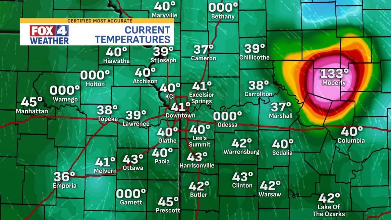
MISSOURI — Early January weather across much of Missouri and eastern Kansas remained seasonable and calm, with most cities reporting temperatures in the upper 30s to low 40s. However, one location sharply stood out on regional temperature maps: Moberly, Missouri, where a shocking 133° reading briefly appeared, triggering confusion and online reactions.
Meteorologists and weather analysts quickly pointed out that the extreme number does not reflect real atmospheric conditions, but instead indicates a sensor, data feed, or graphical error rather than an actual temperature spike.
What the Data Shows Across Missouri and Kansas
Weather graphics from FOX4 and regional monitoring systems showed a consistent and realistic pattern across the region:
- Kansas City metro: 40–41°
- Topeka, Lawrence, St. Joseph: upper 30s
- Columbia, Sedalia, Warrensburg: near 40°
- Southern Missouri: low 40s
- Eastern Kansas: mid to upper 30s
The lone outlier was Moberly, where a bright, heat-map-style core displayed 133°, completely disconnected from surrounding readings.
Why the 133° Reading Is Not Real
Experts note several common reasons for this kind of anomaly:
- Faulty surface sensor
- Data interpolation glitch
- Radar or model overlay error
- Unit conversion or software bug
Because all surrounding locations were 90+ degrees cooler, the reading is meteorologically impossible under current conditions. No heat advisory, fire weather alert, or atmospheric support existed to justify such a spike.
Weather Pattern Context
The broader weather setup supports the conclusion that the number was erroneous:
- Stable winter air mass
- Light winds
- No frontal boundary or compressional heating
- No downslope wind events
- No solar amplification (cloud cover present)
In short, nothing in the synoptic setup supports extreme heat anywhere in Missouri or Kansas.
Public Reaction and Confusion
The image quickly circulated online, with viewers joking about Moberly being “cooked” while the rest of the region enjoyed a pleasant winter day. Meteorologists emphasized that brief visual anomalies like this occasionally appear, especially during live data ingestion or map refresh cycles.
Key Takeaway
Despite the alarming number:
- No extreme heat occurred
- No danger was present
- Regional weather remained normal and calm
This incident serves as a reminder that single-point outliers must always be verified against surrounding data, especially in real-time weather graphics.
What Happens Next
Data systems typically self-correct within minutes once faulty inputs are removed or refreshed. No follow-up alerts or advisories were issued for central Missouri.
If you see a number that wildly contradicts nearby readings, it’s almost always a technical glitch — not a sudden weather disaster.
Weather maps can sometimes be misleading when isolated data points fail or visual glitches appear, but understanding the broader pattern helps separate real threats from harmless errors. What do you think caused the Moberly temperature anomaly — sensor failure or data-processing glitch? Share your thoughts and follow more data-driven weather breakdowns and regional updates at ChicagoMusicGuide.com.