Michigan, Ohio, Wisconsin, New York See Below-Normal Great Lakes Ice as January 2026 Coverage Lags Historical Average
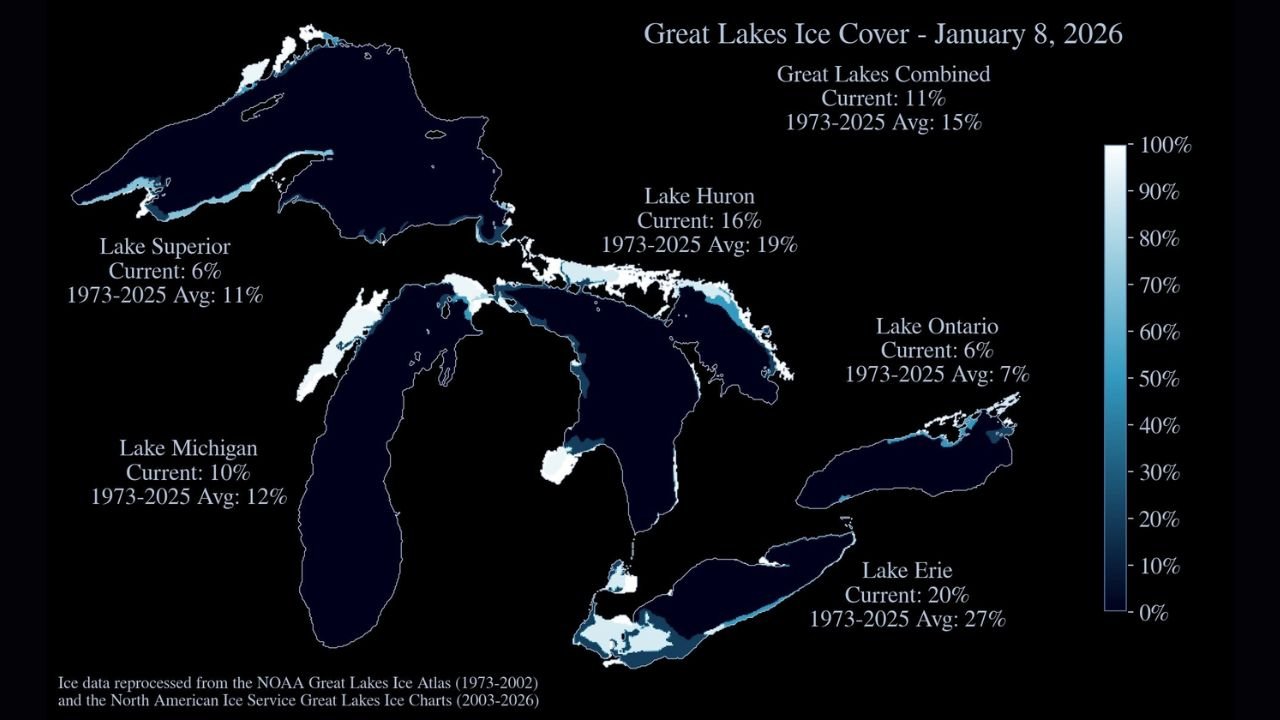
ILLINOIS — New ice data for January 8, 2026 shows below-average ice cover across the Great Lakes, with the system sitting at 11% total ice coverage, well under the long-term seasonal average of 15%. The numbers highlight a slow start to winter ice development across lakes bordering Michigan, Ohio, Wisconsin, New York, Pennsylvania, Indiana, Illinois, and Minnesota, despite several cold snaps earlier this season.
Meteorologists tracking Great Lakes ice trends say the delayed freeze reflects persistent temperature swings, wind-driven mixing, and limited sustained Arctic air, all of which have kept large portions of the lakes open into early January.
Great Lakes Ice Coverage Snapshot (January 8, 2026)
Here’s how each lake currently compares to its historical average:
- Lake Superior: 6% ice (average: 11%)
- Lake Michigan: 10% ice (average: 12%)
- Lake Huron: 16% ice (average: 19%)
- Lake Erie: 20% ice (average: 27%)
- Lake Ontario: 6% ice (average: 7%)
While Lake Erie leads the pack — as it often does due to its shallower depth — it is still running 7 percentage points below normal for this point in January.
Why Ice Growth Is Lagging Across the Region
Forecasters point to several key factors slowing ice expansion across the Great Lakes basin:
- Inconsistent cold air: Arctic outbreaks have been brief, allowing ice to form but not consolidate.
- Strong winds: Wind events have repeatedly broken up thin ice and pushed it offshore.
- Above-normal water temperatures: Warm lake surfaces are delaying widespread freeze-up.
- Frequent storm systems: Passing lows keep water agitated, preventing stable ice growth.
This pattern has been especially noticeable along Lake Michigan’s eastern shore, parts of Lake Superior near Minnesota, and Lake Ontario along New York’s shoreline, where ice formation remains patchy.
Regional Impacts for Great Lakes States
The slow ice season carries ripple effects across the Midwest and Great Lakes region:
- Lake-effect snow: Less ice allows more moisture to feed snow bands, particularly downwind of Lake Erie and Lake Michigan.
- Shipping season: Reduced ice has allowed commercial shipping lanes to remain more accessible longer than usual.
- Coastal erosion: Open water combined with winter storms increases wave action along shorelines in Michigan, Wisconsin, and Ohio.
- Ecosystems: Delayed ice alters winter habitats for fish and wildlife that rely on stable ice cover.
What Happens Next?
Long-range outlooks suggest colder air may return later in January, which could allow ice coverage to increase rapidly if sustained sub-freezing temperatures lock in. Historically, some winters have seen sharp ice growth in late January and February, even after slow starts.
However, meteorologists caution that timing matters — without prolonged cold, the Great Lakes may once again finish the season with below-average maximum ice cover, continuing a trend seen in several recent winters.
Great Lakes ice conditions affect everything from weather patterns and snowfall to shipping, fishing, and shoreline safety. What are you seeing near your lakefront this winter? Share your observations and stay updated with regional weather coverage at ChicagoMusicGuide.com.