Louisiana, Mississippi, and Alabama Face Nocturnal Tornado Threat as SPC Warns Severe Potential Will Increase Overnight
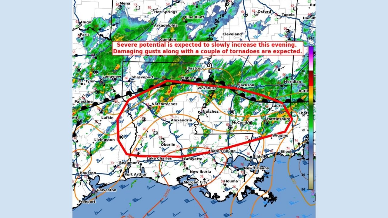
LOUISIANA — While daytime conditions remained relatively quiet, forecasters are urging residents across the Deep South to stay alert tonight as a nocturnal severe weather threat begins to unfold. The Storm Prediction Center (SPC) has issued Mesoscale Discussion #16, warning that severe potential is expected to slowly increase this evening, with the risk of damaging wind gusts and a couple of tornadoes developing after dark.
The concern centers on a strengthening line of thunderstorms advancing eastward across Louisiana, southern Mississippi, and into southwest Alabama, a region that historically sees higher impacts during overnight severe weather events. Forecasters emphasize that nighttime storms are especially dangerous due to reduced visibility and the likelihood that people may be asleep when warnings are issued.
SPC Mesoscale Discussion Highlights Tornado and Wind Risk
According to the SPC, environmental conditions are becoming increasingly favorable for organized severe storms. The discussion notes that damaging wind gusts are the primary threat, but also explicitly mentions the possibility of one or two tornadoes, particularly within stronger storm segments or embedded circulations.
The mesoscale discussion outlines a watch probability of around 80%, indicating a strong likelihood that a Severe Thunderstorm Watch or Tornado Watch may be required as storms continue to intensify. Forecasters are closely monitoring how quickly instability increases ahead of the advancing storm line.
Radar imagery shows widespread showers and thunderstorms already ongoing, but with signs that storms could become more intense as wind shear strengthens this evening.
Primary Impact Zone Spans Louisiana Into Mississippi and Alabama
The highest concern stretches from central and southern Louisiana, including areas near Lake Charles, Alexandria, and Baton Rouge, eastward into southern Mississippi near Natchez, McComb, and Jackson, and onward into southwest and central Alabama.
Within this corridor, storms may organize into a broken line capable of producing 55 to 70 mph wind gusts, strong enough to down trees, damage roofs, and cause scattered power outages. The SPC also notes that any tornadoes that form could occur quickly and with limited warning, especially overnight.
This setup is characteristic of cool-season Gulf Coast severe weather events, where strong winds aloft compensate for only modest surface instability.
Why the Overnight Timing Increases Risk
Forecasters stress that nocturnal tornado threats are among the most dangerous severe weather scenarios in the Southeast. Storms developing after sunset often move faster, warnings may be shorter, and residents are less likely to receive alerts while sleeping.
The SPC highlights increasing low-level wind shear this evening, a key ingredient for tornado development. Combined with rich Gulf moisture and an approaching frontal boundary, the environment supports rotating storms even without classic daytime heating.
Residents are strongly encouraged to ensure multiple alert methods are enabled, including mobile phone emergency alerts and NOAA weather radios, before going to bed.
Potential Storm Impacts Include Power Outages and Travel Issues
Beyond tornadoes, the most widespread impacts tonight are expected to come from strong to damaging straight-line winds. These winds can cause tree damage, knock out power, and make travel hazardous—especially for high-profile vehicles.
Heavy rain may also accompany stronger storms, reducing visibility and leading to localized flooding in poor drainage areas. While flooding is not the primary concern in this discussion, saturated ground can worsen tree damage when winds increase.
Emergency managers caution against nighttime travel unless absolutely necessary and urge residents to identify a safe shelter location in advance.
What Residents Should Do Tonight
With severe potential increasing after dark, residents across Louisiana, Mississippi, and Alabama should take the following precautions:
- Keep phones charged and alerts enabled
- Identify a safe interior room away from windows
- Monitor local forecasts for watch or warning issuances
- Avoid sleeping without a way to receive emergency alerts
Even brief tornadoes can cause significant damage, particularly in mobile home communities or wooded areas.
As the Deep South enters this overnight severe weather window, staying informed will be critical. Weather conditions can change rapidly, and storms may intensify with little notice after sunset. For continued updates on severe weather alerts, overnight storm developments, and regional forecast coverage across the South and beyond, visit ChicagoMusicGuide.com.