Illinois, Ohio, Pennsylvania, New York, and Mid-Atlantic States May See Sharply Colder Pattern as Jet Stream Dips January 15–20
ILLINOIS — Long-range forecast models are increasingly signaling a notable shift toward colder conditions across the eastern half of the United States during the middle of January, with temperatures potentially reaching their lowest levels between January 15 and January 20. Data from multiple computer models suggests a pronounced jet stream dip, allowing Arctic air to spill southward into the Midwest, Great Lakes, Mid-Atlantic, and Northeast, while the western U.S. trends milder.
While this shift does not guarantee snow or major storms on its own, it creates a more favorable background pattern for winter weather events should storm systems track through the region during this window.
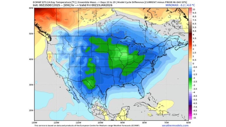
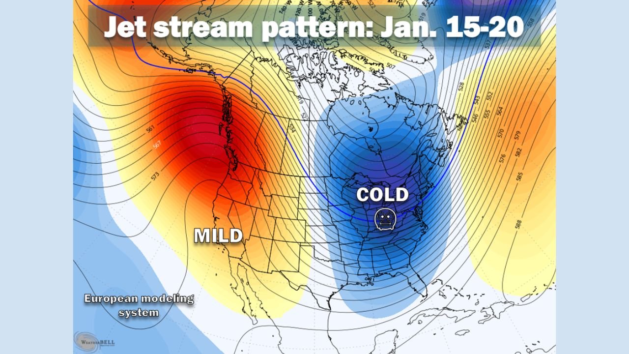
Jet Stream Pattern Signals Cold Air Intrusion Into the East
Forecast imagery highlighting the jet stream configuration shows a deep trough developing over the eastern United States, a classic signal for sustained cold air delivery. This setup effectively separates milder Pacific air in the West from Arctic and polar air masses in the East, increasing the likelihood of prolonged below-average temperatures.
For states such as Illinois, Ohio, Pennsylvania, and New York, this pattern often results in daytime highs struggling to rebound, especially if cloud cover or snowpack becomes established. Overnight lows may also dip well below seasonal averages.
Meteorologists emphasize that the strength and persistence of this trough will determine how intense and long-lasting the cold becomes.
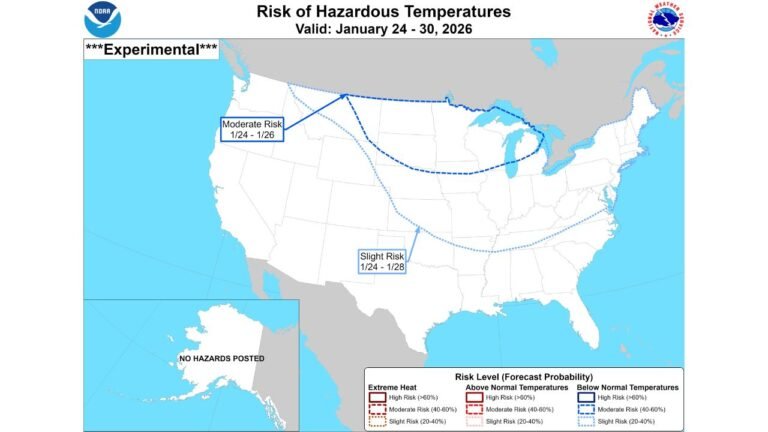
Temperatures May Bottom Out Between January 15 and 20
Ensemble guidance suggests that the coldest period of this pattern may occur during the January 15–20 timeframe, when the jet stream reaches its deepest southward position. During this window, temperatures across much of the Midwest and East could fall well below normal for mid-January.
In urban areas, the cold may be most noticeable through biting wind chills, while rural locations could experience even sharper overnight lows. The pattern also raises concerns about energy demand, frozen pipes, and travel challenges if snow or ice accompanies the cold.
While exact temperature values remain uncertain at this range, the overall signal for a pronounced cool-down is growing stronger with each model cycle.
Snow Chances Depend on Storm Track and Timing
The key question surrounding this colder pattern is storminess. Models are hinting at potential weather systems around January 15–16 and again near January 19, but forecasters caution that it is far too early to determine whether these systems will materialize or track close enough to bring significant snow.
If storms develop while cold air is firmly in place, parts of Illinois, Ohio, Pennsylvania, upstate New York, and interior Mid-Atlantic regions could see snow or mixed precipitation. Conversely, if storms track too far west or east, impacts could be minimal despite the cold air.
This uncertainty is typical for long-range forecasting, particularly when dealing with multiple potential systems.
Why This Pattern Is Being Watched Closely
Mid-January is climatologically one of the coldest periods of the year, and when a favorable jet stream pattern aligns, impacts can escalate quickly. Even modest storms can become disruptive when paired with cold air, snow, or ice.
Forecasters are closely monitoring how the jet stream evolves, as small shifts in its position can dramatically change local outcomes. Confidence in specific impacts will increase as the timeframe draws closer and shorter-range models come into focus.
For now, the primary takeaway is heightened awareness rather than immediate concern.
What Residents Should Keep in Mind
As this mid-January pattern takes shape, residents across the Midwest and Eastern U.S. should be prepared for:
- A noticeable drop in temperatures
- Increased potential for snow or winter weather if storms develop
- Possible travel and infrastructure impacts if cold and storms coincide
Those with upcoming travel plans or outdoor events during this period should stay flexible and monitor forecast updates.
As the January 15–20 window approaches, forecast clarity will continue to improve. This developing pattern has the potential to deliver the coldest conditions of the month and set the stage for winter weather across several states. For ongoing coverage of long-range forecasts, winter weather trends, and regional impacts across the U.S., visit ChicagoMusicGuide.com.