Kansas, Oklahoma, Missouri and Texas Brace for Spring-Like Warmth as January Temperatures Surge Into the 60s and 70s
UNITED STATES — A remarkable January warm-up is unfolding across the central United States, with forecast data showing spring-like temperatures spreading across Kansas, Oklahoma, Missouri, northern Texas, and parts of the Midwest by Tuesday, creating conditions that will feel far removed from mid-winter norms.
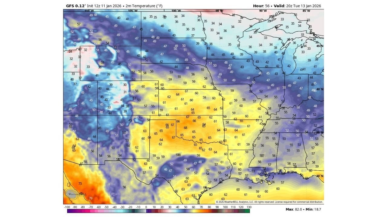
Forecast models indicate that highs will climb into the upper 60s and even low 70s across the central Plains, while parts of the Midwest and lower Missouri Valley push well above average for mid-January. This warm pattern is being driven by a broad ridge of high pressure dominating much of the central U.S., allowing warm air to surge northward ahead of the next midweek system.
This is not a short-lived afternoon spike — the warmth is widespread, sustained, and unusually strong for this time of year.
Central Plains and Midwest See Temperatures 20–30 Degrees Above Normal
Temperature anomaly maps show Kansas, Oklahoma, Missouri, and portions of Nebraska and Iowa running 20 to 30 degrees above seasonal averages. In several locations, forecast highs approach levels more typical of early April than mid-January.
Cities across the Plains may challenge daily temperature records, especially where snow cover is minimal, allowing the ground to warm efficiently under mild air and filtered sunshine. Overnight lows will also stay elevated, reducing the usual overnight cooling that defines winter weather in the region.
Why It Will Feel Nothing Like January
The data clearly shows a deep contrast across the country, with cold air locked farther north while warm air dominates the central U.S. The absence of Arctic air and the presence of strong southwest flow aloft are combining to create a classic midwinter warm surge.
While colder air remains across parts of the Upper Midwest and Great Lakes, the core of the warmth centers squarely over the Plains and south-central states, keeping winter firmly at bay for several days.
Midweek Pattern Shift Brings Cooler Air East — But No Major Winter Threat Here
By midweek, a storm system moving east will introduce cooler temperatures to the eastern third of the country, with some wintry precipitation possible in the Midwest and Northeast. However, based on current guidance, this system does not appear to pose a significant winter weather threat for the Plains or Deep South.
Importantly, recent data also pushes back against viral claims of a major snowstorm or blizzard in the southern U.S. Model guidance continues to support only minor flurries at best in isolated areas, with no meaningful accumulation or societal impacts expected.
What to Expect Going Forward
- Spring-like warmth dominates through Tuesday
- Cooling trend arrives midweek, mainly east
- No credible signals for a major snow or ice storm in the South
- Cold air becomes the main story later in the month, not snow
Winter is far from over, but this particular pattern favors warmth over winter hazards across much of the central United States.
Stay Updated With ChicagoMusicGuide.com
Weather patterns can shift quickly, and we’ll continue monitoring how this unusual January warmth evolves — and when colder air finally makes a more meaningful return. Stay connected with ChicagoMusicGuide.com for clear, no-hype weather updates, national outlooks, and real impacts explained simply.
Have you noticed how different this January feels where you live? Let us know — and keep checking back for the next update.