Florida, Georgia, South Carolina, North Carolina, and Virginia Face Sunday Storm Signal With Coastal Rain and Inland Snow Risk
ATLANTA, GEORGIA — Forecast guidance is starting to look “more and more interesting” for Sunday, with a developing signal that could bring a coastal rain swath across parts of Florida, Georgia, South Carolina, and North Carolina, while colder air to the north supports a snow potential inland from portions of Tennessee and Kentucky into Virginia and West Virginia. Forecasters are not calling it a locked-in trend yet, but if the signal holds or strengthens in the next set of model runs, it could become a legitimate late-weekend weather maker for the region.
What stands out most in the data is the split nature of the setup: moisture and rain favored nearer the Atlantic coast, with wintry precipitation potential increasing farther inland where colder air is better established.
What The Sunday Setup Looks Like: Coastal Rain From Florida to North Carolina
Model depictions of 6-hour precipitation type suggest a notable ribbon of rain developing or expanding near the Atlantic coastline, with the most consistent precipitation signal positioned offshore and brushing coastal sections of:
- Florida (especially the Atlantic side)
- Georgia (coastal influence and nearby waters)
- South Carolina (coastal counties and near-shore zone)
- North Carolina (coastal plain and outer banks vicinity)
This is a common winter-season storm look in the Southeast: high pressure and cooler air inland, with the stronger moisture feed riding along the coastal front and nearby waters. If the rain band becomes more organized, localized heavier pockets can develop, which matters for travel—particularly along coastal highways and metro corridors that sit closer to the moisture plume.
Even if inland totals aren’t extreme, a steady coastal rain can still create slippery roads, ponding in low spots, and a more difficult driving window Sunday into early Monday, depending on how quickly the system progresses.
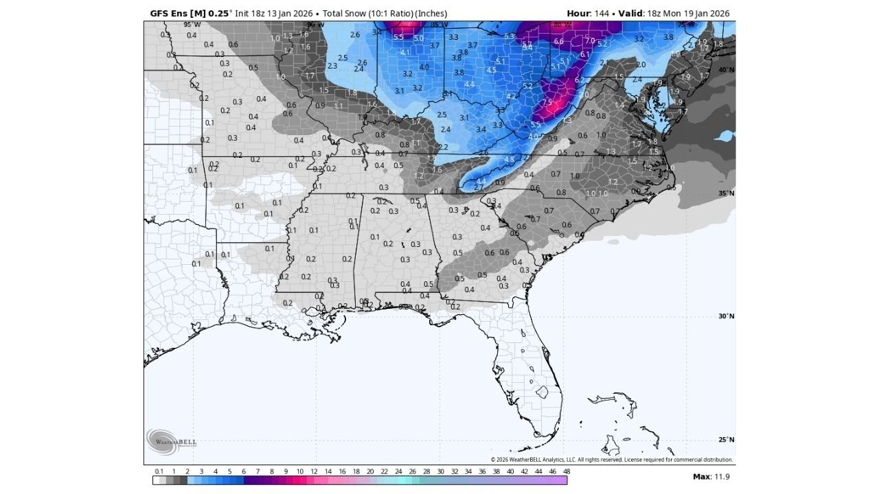
Where Snow Could Develop: Tennessee, Kentucky, Virginia, and West Virginia In The Colder Zone
Ensemble snowfall graphics add a second layer to the story: while the coast leans rainy, the colder interior has a clearer pathway to accumulating snow in a swath extending from parts of the Ohio Valley/Appalachians into the Mid-Atlantic. The signal is strongest where colder air and lift overlap, with the most notable snow potential indicated across portions of:
- Kentucky and Tennessee (especially higher terrain and northern sections)
- West Virginia (a frequent bullseye in these setups)
- Virginia (including areas near and west of the Blue Ridge)
- Interior sections of North Carolina (especially higher elevations)
The important detail here is that this does not look like a “snow everywhere” event for the Southeast. Instead, it looks like a rain-to-snow gradient setup—where small track shifts can dramatically change who gets accumulating snow versus cold rain or a mix.
If the storm’s precipitation shield expands inland at the same time colder air remains in place, the snow footprint can grow. If the storm stays suppressed offshore, snow becomes more limited and concentrated mainly in the higher terrain and farther north.
Why Forecasters Are Cautious: This Isn’t A Trend Yet, But It’s A Signal
The commentary attached to the images captures the uncertainty well: the system looks more interesting, but it’s not being labeled a trend yet. That caution is reasonable because Southeast winter setups often hinge on subtle differences in:
- Storm track (offshore vs. hugging the coast)
- Strength and placement of high pressure to the north (cold air supply)
- The timing of the deepest moisture arriving versus the coldest air being in place
- The exact location of the rain/snow line, which can wobble quickly
In other words, the signal is meaningful, but the details are still being negotiated by the models. If the next 24 hours of guidance keeps the same idea—or turns more aggressive—confidence rises that Sunday’s system could deliver more impactful weather somewhere across the Southeast-to-Appalachians corridor.
What To Watch Next: The Two Outcomes That Change Impacts Fast
As this forecast tightens, the biggest “fork in the road” is whether the storm’s moisture axis stays mostly offshore or pushes farther inland:
- More offshore track:
- Coastal rain remains the main story for FL/GA/SC/NC
- Inland snow is more confined to higher terrain and farther north
- Lower overall disruption except localized coastal downpours
- Stronger/closer-to-coast track:
- Rain expands inland and becomes more widespread
- The snow zone can sharpen and intensify from TN/KY into VA/WV
- Higher “boom/bust” potential for who ends up with impactful accumulation
For anyone with Sunday travel, the smart move is to check updates focusing on (a) coastal rain coverage and (b) where ensembles place the highest snow probabilities inland. Those two elements will define whether this is mostly a wet coastal nuisance—or a more consequential winter-weather event in the interior.
If you’ve got weekend plans, travel, or live events on the calendar, keep an eye on how this signal evolves—because the Southeast’s most disruptive winter setups are often the ones that look “iffy” until the last couple of forecast cycles. For more weather-driven planning updates tied to travel and event schedules, visit ChicagoMusicGuide.com.