Indiana, Michigan, and Illinois Face Dangerous Lake-Effect Snow Surge as LaPorte County Could See 17–27 Inches
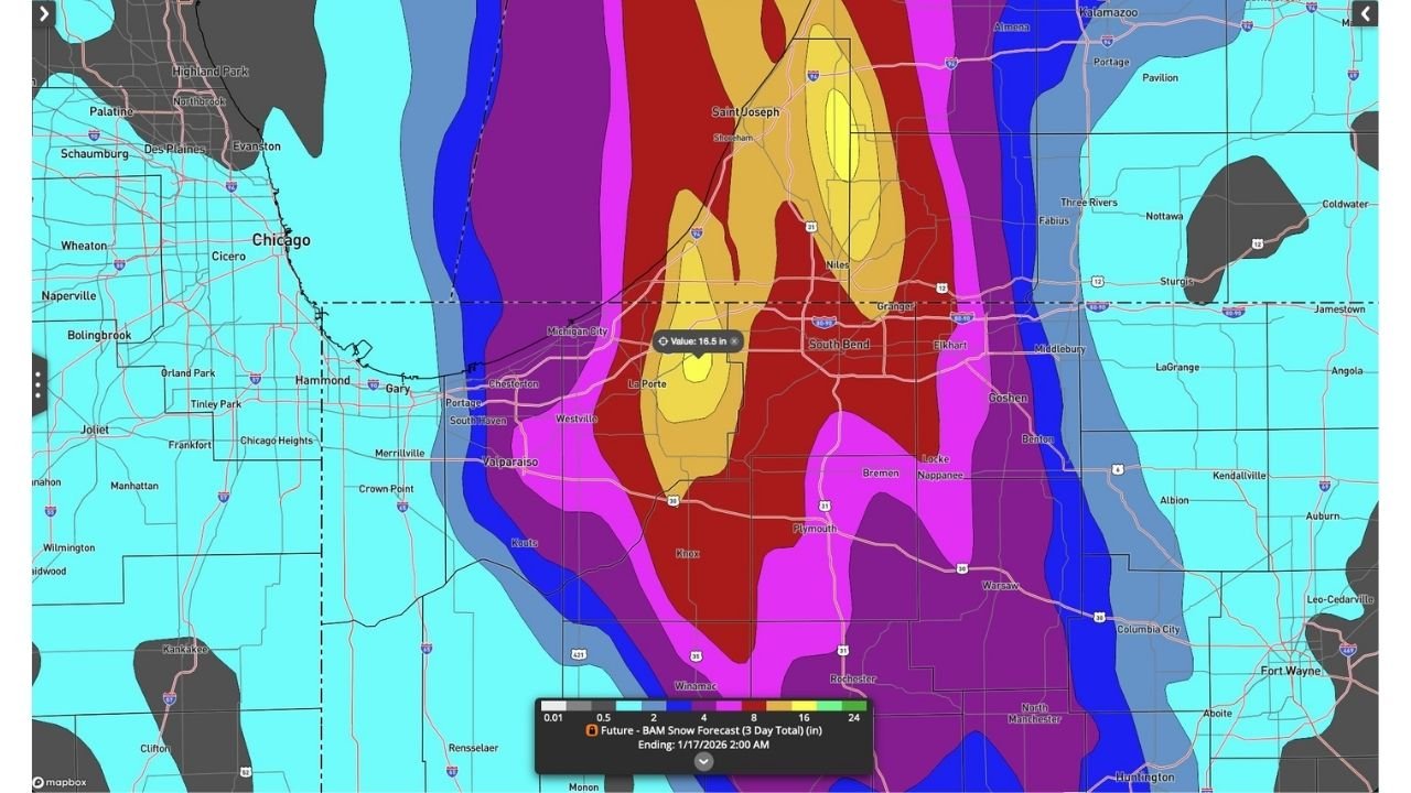
INDIANA – A powerful lake-effect snow machine is lining up along Lake Michigan with LaPorte County, Indiana in the crosshairs, where forecast guidance is pointing to a likely total near 17 inches and high-end outcomes approaching 27 inches over roughly the next 30 hours. The setup also puts nearby parts of northwest Indiana, southwest Michigan, and the Illinois lakeshore region on alert for rapidly changing conditions depending on where the heaviest band locks in.
What the latest data is showing right now
Forecast graphics centered on the LaPorte–Michigan City corridor show the sharpest snow gradient right along and just inland from Lake Michigan. That means one town can be dealing with near-whiteout snowfall while another just 10–20 miles away sees far less.
Key takeaways from the latest map-based forecast:
- LaPorte County, IN is the main bullseye, with the highest probabilities for double-digit totals.
- The most intense banding appears capable of stretching toward the South Bend area and into southwest Michigan, depending on wind direction.
- Parts of the Chicago-to-NW Indiana corridor (including the Gary/Hammond side of the metro) sit close enough to the edge that conditions could swing quickly if the band wobbles west.
Why this could turn ugly fast
Lake-effect events are notorious because the snow can come in bursts—not a steady, manageable snowfall. When the band intensifies, visibility can drop hard in minutes, and roads can go from wet to snow-covered before drivers have time to react.
What makes this setup especially disruptive:
- Very high snowfall rates are possible inside the band (the kind that overwhelms plows for a time).
- Localized totals can be extreme even if surrounding areas look “fine.”
- If winds shift, the heaviest snow can pivot and start hitting a different set of communities with little notice.
Timing and the most likely window for major impacts
The forecast discussion tied to this setup emphasizes the next 30 hours as the key window, with snow expected to continue in rounds as the lake-effect band organizes and reloads. If you’re traveling through LaPorte County or along major routes that feed into the region, plan for on-and-off whiteouts and changing road conditions—especially during nighttime and early-morning periods when temps are lower and visibility issues are harder to spot.
Travel risks: what drivers should expect in the hardest-hit zone
If the band parks over LaPorte County (or slides into adjacent counties), the main hazards won’t just be snow totals—it’ll be how quickly the conditions deteriorate.
Expect these problems in the core band:
- Near-zero visibility at times (snow bursts and blowing snow)
- Sudden slick spots, especially on bridges, ramps, and untreated back roads
- Slow-moving or stuck vehicles that can create chain-reaction backups
- Plow delays when snowfall rates spike faster than crews can clear lanes
How to prepare right now
Even if you’re outside the jackpot zone, this is the kind of forecast where being “close” still matters.
Smart moves before the snow peaks:
- Avoid unnecessary driving in LaPorte County if you can.
- If you must travel: keep extra fuel, a phone charger, blanket, and basic emergency kit in the car.
- Give plows room and assume visibility can drop without warning.
- If you live in the band’s likely path, charge devices and plan for slower commutes and difficult neighborhood roads.
What to watch next
The most important detail going forward is band placement. A small wind shift can move the heaviest snow axis from one corridor to another—changing who gets the 6–10 inch day versus who ends up in the 15–25+ inch zone.
If you’re in LaPorte County (IN) or travel between Chicago (IL), northwest Indiana, and southwest Michigan, keep checking updates frequently because lake-effect forecasts can tighten quickly as the event unfolds.
If you’re in the path of this snow band, what are you seeing outside right now—steady snow, bursts, or nothing yet? Share what it looks like in your area, and follow along for more weather updates at ChicagoMusicGuide.com.