Maryland, Virginia, and Pennsylvania Snow Forecast Hinges on AI vs Traditional Models as I-95 Corridor Comes Into Focus
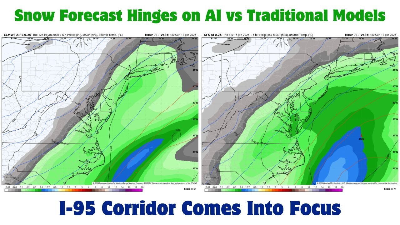
BALTIMORE, MARYLAND — A growing forecast debate is unfolding across Maryland, Virginia, and Pennsylvania as artificial intelligence–driven weather models clash with traditional guidance over the potential for Sunday snow along the I-95 corridor. Recent runs from AI-enhanced GFS and AI-based ECMWF (AIFS) solutions bring measurable snow much farther west — directly into major metro areas — while legacy GFS and Euro models remain more conservative.
This same type of model disagreement played out earlier this winter, and on that occasion, the AI solutions verified more accurately, raising forecaster interest as the next system approaches.
AI Models Drive Snow Inland to the I-95 Corridor
The latest AI GFS and AI-based ECMWF AIFS guidance shows a stronger Sunday wave digging deeper into the Mid-Atlantic. Under these solutions, precipitation expands inland, allowing snow to reach the I-95 corridor, including parts of Baltimore, Washington, D.C., and nearby suburbs.
The key difference lies in the weaker Saturday system depicted by AI guidance. By limiting Saturday’s precipitation and energy, the models allow the Sunday wave to amplify more aggressively, pulling colder air and moisture farther west. This evolution increases the chance of snow rather than rain for inland locations.
Snowfall amounts in these AI scenarios remain modest but impactful, especially for urban corridors where even light accumulations can disrupt travel.
Traditional Euro Shows Saturday Snow Near Baltimore
Meanwhile, the traditional ECMWF (Euro) paints a different picture. In that solution, a stronger Saturday wave produces close to one inch of snow around Baltimore, but limits how much energy remains for Sunday. As a result, the follow-up system is weaker, with precipitation staying closer to the coast and largely missing inland areas.
This split highlights a classic forecasting dilemma: whether the atmosphere favors one stronger wave or two staggered systems, with the second becoming the primary snow producer.
Why Saturday’s Wave Matters So Much
Meteorologists emphasize that Saturday’s system is the pivot point in this forecast. If it remains weak, as AI guidance suggests, the Sunday wave has room to deepen, expand westward, and tap colder air. If Saturday overperforms, as shown in traditional models, Sunday’s snow potential drops significantly.
Small differences in timing, energy transfer, and jet-stream interaction will ultimately decide which scenario plays out — and those details may not fully resolve until closer to the event.
What This Means for Maryland, Virginia, and Pennsylvania
For now, residents across central Maryland, northern Virginia, and southeastern Pennsylvania should prepare for forecast volatility. The range of outcomes still includes anything from minor flurries to a light but widespread snow event Sunday, particularly near Interstate 95.
While this does not currently appear to be a major winter storm, the setup carries enough uncertainty to warrant close monitoring, especially given recent AI model success in similar patterns.
Next Model Runs Will Be Critical
Forecasters are watching upcoming 00z and 12z model cycles closely. These runs should clarify whether AI guidance once again outperforms traditional models — a trend that, if repeated, could further elevate AI’s role in operational forecasting.
Until then, confidence remains moderate, and adjustments are likely as new data is ingested.
As Maryland, Virginia, and Pennsylvania brace for another evolving winter setup, the battle between AI-driven forecasts and traditional models underscores how quickly expectations can change. For continued updates on Mid-Atlantic snow potential, model trends, and weather impacts on weekend plans and events, stay with ChicagoMusicGuide.com for the latest weather coverage.