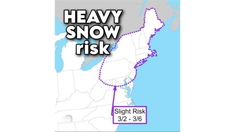
North Carolina, Georgia, South Carolina Face Rare Light Snow Setup as Marginal Winter System Moves Through Southeast

UNITED STATES — A fast-moving but unusually cold weather system is set to sweep across parts of the Southeast on Sunday, bringing a rare chance of light snow to areas of North Carolina, southern Georgia, and parts of South Carolina, according to updated model guidance and National Weather Service forecasts.
This is not a classic winter storm, but the setup is notable for the region. Forecast data shows rain developing late Saturday night, then briefly mixing with or changing to wet snow Sunday morning into early afternoon, especially where colder air filters in behind the departing system.
What the Latest Forecast Shows
Updated guidance indicates snow totals have edged slightly higher, though impacts remain limited.
- General snowfall: a dusting to 0.5 inches
- Isolated higher spots: near 1 inch, mainly on grassy or elevated surfaces
- Primary accumulation zone: central and northern North Carolina
- Southern fringe: parts of southern Georgia and eastern South Carolina may see a coating — a rarity for mid-January
Temperatures are expected to stay just above freezing for much of the day, which will limit how much snow can stick, especially on roads.
Timing: When Snow Is Most Likely
The window for snow is short and narrow:
- Early morning: rain develops
- Late morning to early afternoon: rain mixes with or flips to wet snow
- Late afternoon: precipitation exits west to east
Because surface temperatures hover in the upper 30s to near 40°F, any snow that falls will melt quickly once precipitation ends.
Snow Probabilities by the Numbers
Forecast probability maps from the National Weather Service show:
- 60–80% chance of seeing at least a trace of snow across much of central North Carolina
- 20–35% chance of reaching 1 inch, mainly in a narrow corridor
- Lower odds farther south, but still enough for snowflakes to be observed — especially east of major highways
This aligns with a low-impact, high-interest setup rather than a disruptive one.
Travel Impacts: Limited, But One Thing to Watch
Widespread travel issues are not expected, but there is one concern later:
- Roads should remain mostly wet during the day
- Sunday night: as skies clear and temperatures drop, leftover moisture may refreeze
- Patchy black ice is possible late Sunday night into early Monday, particularly on bridges and untreated surfaces
Drivers should stay alert during the early Monday commute, even if snow totals are minimal.
Why This Event Matters
Snow events of any kind are uncommon this far south, especially in southern Georgia. Even a brief burst of snow is noteworthy and often becomes a “social-media snow” event, with photos and videos spreading quickly despite limited accumulation.
Meteorologically, this system highlights how marginal temperature setups can still produce snow when cold air arrives at just the right time behind departing rain.
Bottom Line
This is not shovel snow and not a winter storm, but it is a legitimate chance for flakes across parts of the Southeast.
Expect:
- A quick-hitting system
- Mostly rain with a brief snow window
- Minor accumulations at best
- A small black-ice risk late Sunday night
Enjoy the novelty if you see flakes — and keep an eye on overnight temperatures before Monday morning travel.
For more regional weather updates and impact-focused forecasts, stay connected with ChicagoMusicGuide.com and share what you’re seeing in your area.