Illinois, Michigan, Minnesota, Ohio and New York Brace for Most Brutal Cold of Winter as Major Storm Threat Builds Nationwide
UNITED STATES — Winter is set to make a forceful comeback next week, with forecast data pointing to the coldest and most dangerous stretch of the season so far for large portions of the Midwest, Great Lakes, and Northeast, while a potential high-impact winter storm looms from the Southern Plains toward the East Coast.
Arctic Air Surge Targets the Midwest and Great Lakes
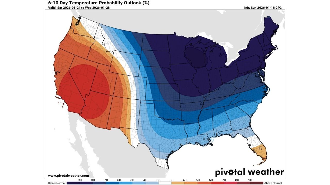
Long-range temperature probability outlooks show an expansive area of well-below-normal temperatures spreading across the central and eastern United States during the January 24–28 window. The coldest anomalies are centered over the Upper Midwest and Great Lakes, where confidence is high that Arctic air will dominate.
Wind chill projections are especially concerning. In parts of the northern Midwest, wind chills could plunge as low as 50 to 60 degrees below zero, creating life-threatening conditions for anyone exposed outdoors for even short periods of time. This level of cold raises the risk of frostbite in minutes and places extreme stress on infrastructure, heating systems, and livestock.
Cold Push Extends South Into the Plains and Southeast
The same Arctic air mass does not remain confined to the northern tier. Forecast guidance shows the cold spilling southward into the Central Plains, Lower Mississippi Valley, and portions of the Southeast, where temperatures are expected to run well below late-January averages.
While wind chills will not be as extreme as in the Upper Midwest, the cold is still notable for regions unaccustomed to prolonged freezes. Nighttime lows dipping into the teens and 20s could lead to frozen pipes, agricultural concerns, and increased heating demand across states from Kansas and Missouri to Tennessee and Georgia.
Major Winter Storm Signal From the Southern Plains to the East Coast
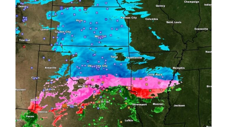
Along the southern edge of the Arctic air, forecasters are closely monitoring a developing storm system that could tap Gulf moisture and track northeastward. Model guidance suggests a large winter storm may be on the table from the Southern Plains through the Ohio Valley and into the East Coast.
This setup raises the potential for a wide range of impacts, including heavy snow on the cold side of the system and mixed precipitation or rain farther south. If the storm aligns with the coldest air, significant snowfall could occur along major travel corridors, particularly across parts of the Mid-Atlantic and Northeast.
Why This Pattern Is Concerning
The combination of extreme cold followed by a possible large-scale winter storm is what makes this pattern especially impactful. Deep Arctic air increases the likelihood that precipitation falls as snow rather than rain, while also allowing snow to accumulate efficiently.
Forecasters note that this could become the most impactful winter weather stretch of the season so far, especially if the storm track favors heavily populated areas along and east of the Mississippi River.
What to Watch Over the Coming Days
- Wind chill advisories and warnings likely across the Midwest as Arctic air arrives
- Rising confidence in storm track and precipitation type from the Southern Plains to the East Coast
- Travel disruptions possible late next week if heavy snow materializes
- Energy demand spikes as prolonged cold grips much of the country
Residents across affected states are encouraged to monitor updated forecasts closely and prepare for both dangerous cold and potential winter storm impacts as confidence increases.
Stay tuned to ChicagoMusicGuide.com for continued weather updates as this high-impact winter pattern evolves and more details become clear.