Texas, Oklahoma, Arkansas, Louisiana, Mississippi and Tennessee Face Potential Major Ice Storm as Dangerous Freezing Rain Signal Grows
UNITED STATES — A developing winter storm pattern is raising growing concern across parts of the central and southern United States, where meteorologists are tracking a potentially significant ice storm that could impact Texas, Oklahoma, Arkansas, Louisiana, Mississippi, Tennessee, and nearby states between Friday, January 23, and Sunday, January 25.
Long-range guidance shows a classic setup for widespread freezing rain, driven by Canadian high pressure forcing shallow subfreezing air southward, while Gulf moisture surges north above the cold surface layer. This overrunning pattern is one of the most reliable ways to produce dangerous ice accumulation, especially across the South and lower Mississippi Valley.
Why This Pattern Is Concerning
Forecast data indicates a strong dome of cold air pressing south through the Plains and Midwest, while warmer, moisture-rich air rides over the top. When rain falls into surface temperatures below freezing, it freezes on contact, leading to ice buildup on roads, trees, power lines, and infrastructure.
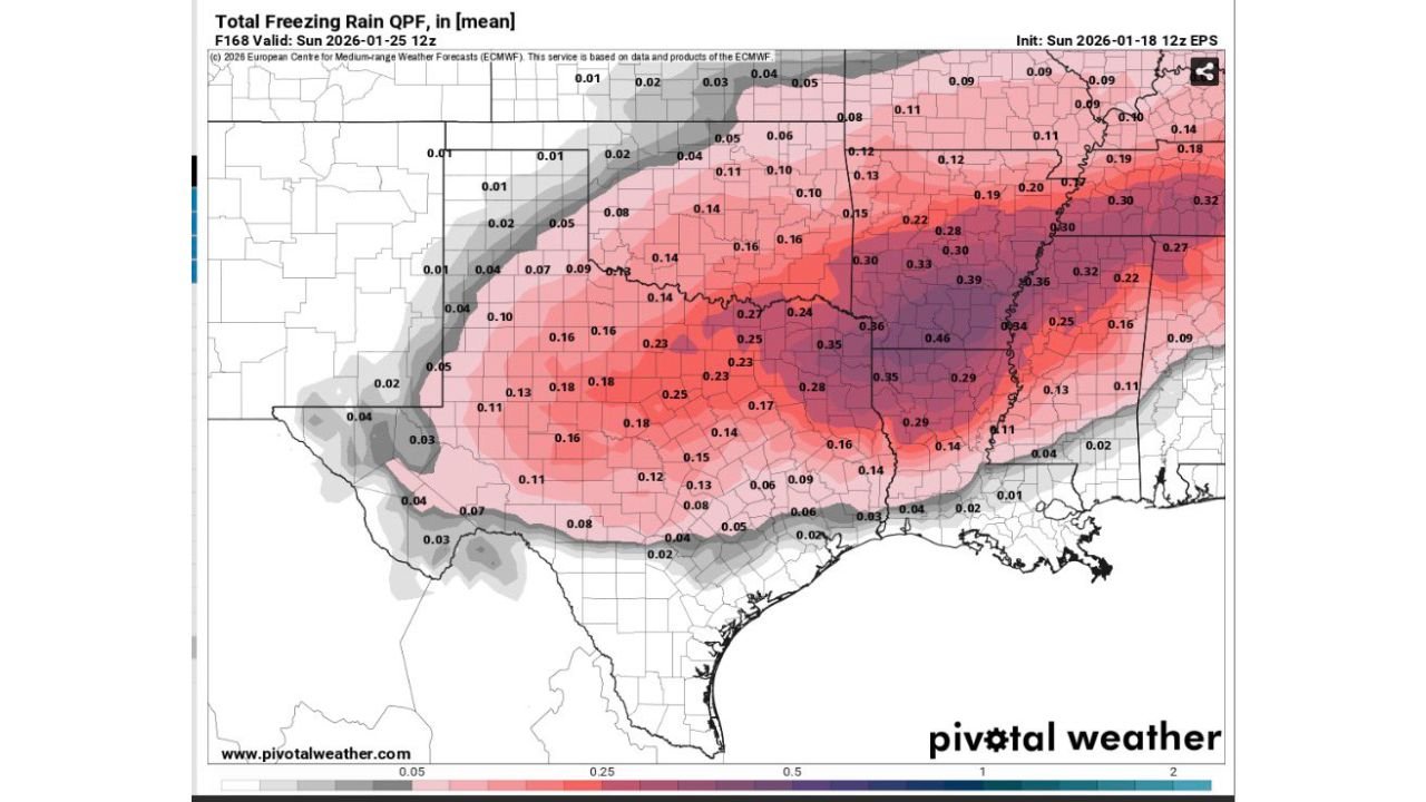
Model guidance shows this freezing rain zone stretching from central Texas through Oklahoma and Arkansas into Mississippi and Tennessee, with the highest ice potential centered near the Arkansas–Mississippi region.
While the exact placement of the ice band is still uncertain, the ingredients for a high-impact event are clearly present.
Ice Accumulation Could Reach Damaging Levels
Ensemble guidance suggests freezing rain accumulations approaching or exceeding 0.25 to 0.50 inches in some areas, which is enough to cause:
- Tree limbs snapping under ice weight
- Downed power lines and widespread outages
- Impassable roads lasting multiple days
- Dangerous travel conditions with no safe window
Even lower totals can be highly disruptive when spread over a wide area, particularly across regions not accustomed to frequent ice storms.
Timing Still Uncertain, but the Threat Is Real
At this range — roughly 5 to 6 days out — forecasters are not locking in exact totals or city-by-city impacts. Instead, attention is focused on trend consistency, which remains strong across multiple model runs.
Key factors still being monitored include:
- The precise placement of the freezing line
- How deep the cold air becomes near the surface
- Whether rain remains liquid aloft or transitions to sleet or snow
- The speed of the system as it moves east
Small shifts in temperature — even one or two degrees — could dramatically change outcomes.
Areas Most at Risk Right Now
Based on current data, the highest concern zone includes parts of:
- Texas (north and east)
- Oklahoma
- Arkansas
- Louisiana (north)
- Mississippi
- Tennessee
This zone may shift north or south as newer data comes in, but residents across these states should remain alert.
What Residents Should Do Now
While it is too early for specific warnings, this is the awareness stage of forecasting. Residents in potentially affected areas should:
- Begin reviewing winter safety plans
- Monitor daily forecast updates
- Ensure emergency supplies and non-perishable food are available
- Avoid unnecessary travel if icing materializes
Ice storms are among the most dangerous winter weather events, often producing impacts that last longer than snowstorms.
Bottom Line
The pattern unfolding late next week strongly supports the potential for a significant ice storm somewhere across the southern and central U.S. While confidence in exact locations is still developing, this is not a setup to ignore.
Forecast details will sharpen over the coming days, and adjustments are expected as models refine the storm’s track and thermal structure.
Stay weather-aware, stay flexible, and keep checking updates as this winter threat evolves.