Georgia Snowfall Corridor Delivers Up to 3 Inches Across Central and East-Central Counties
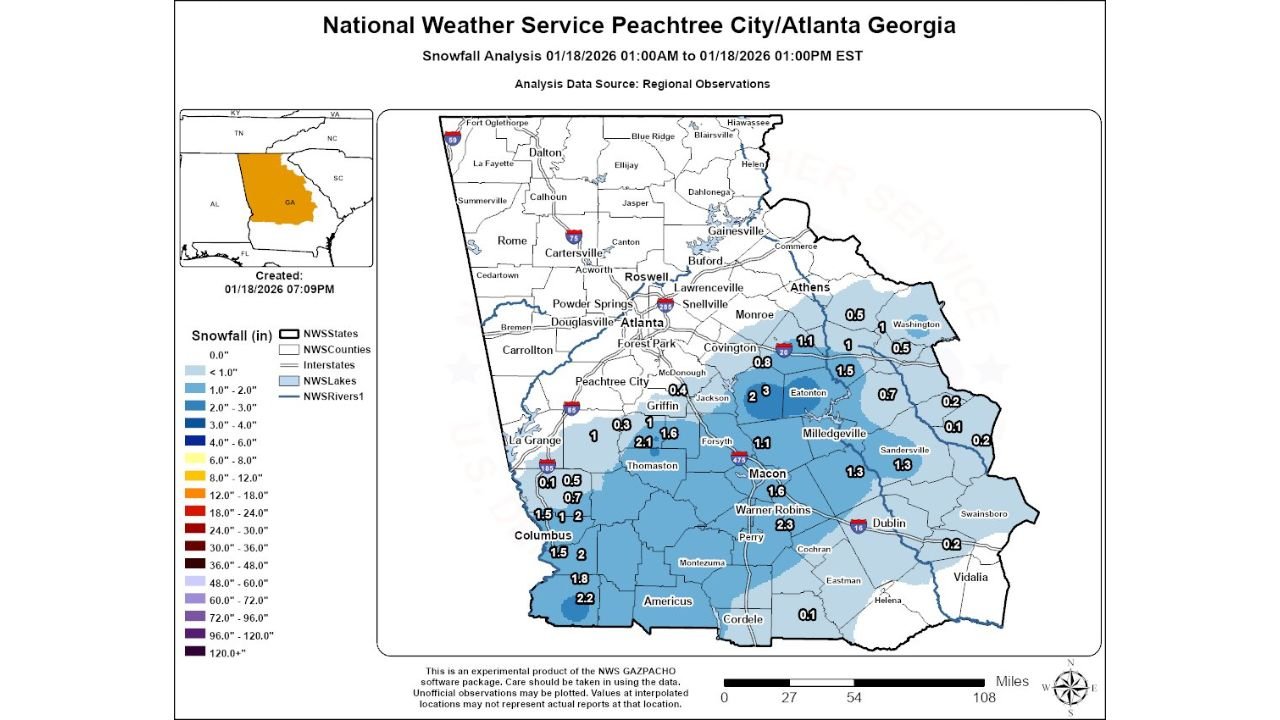
GEORGIA — A narrow but impactful snowfall corridor moved across north and central Georgia early Sunday, January 18, 2026, producing measurable snow totals as high as 3 inches in select communities. The event, confirmed by National Weather Service Peachtree City/Atlanta observations, unfolded during the morning hours and tapered off by early afternoon, leaving behind slick roads, localized travel slowdowns, and a rare winter scene for parts of the state.
The snowfall was concentrated in a thin southwest-to-northeast band, meaning some towns picked up more than two inches of snow while nearby locations saw only a dusting. Reports compiled by the National Weather Service show that the highest accumulations were tightly clustered, underscoring how sharply snowfall totals varied across relatively short distances.
Where the Heaviest Snow Fell in Georgia
The most significant snowfall was reported across central and east-central Georgia, where several locations measured 2 to 3 inches of snow. According to official reports, Monticello topped the list with 3.0 inches, while areas near Eatonton, Bonaire, and Lumpkin reported totals between 2.2 and 2.7 inches.
Additional communities including Meansville, Cusseta, and areas north of Powerville also reached or exceeded the 2-inch mark, making this one of the more notable January snow events for central Georgia in recent years. These totals were recorded during the late morning hours, when snowfall rates briefly intensified within the narrow band.
Cities and Counties With Lighter Accumulations
Outside the core snow corridor, snowfall totals dropped off quickly. Much of metro Atlanta and surrounding suburbs reported less than 1 inch, with some locations seeing only trace amounts. Cities such as Griffin, Mansfield, Sparta, and Locust Grove generally recorded between 0.5 and 1 inch of snow.
Farther southeast, locations including Dublin, Louisville, Eastman, and Swainsboro saw minimal accumulations, often one-quarter inch or less. This sharp gradient highlights how narrowly focused the snow-producing system was as it crossed Georgia.
Timing and Meteorological Setup
The snow began during the pre-dawn hours on Sunday morning and continued into late morning before ending by early afternoon. The event was driven by a fast-moving upper-level disturbance interacting with shallow cold air already in place across central Georgia.
Because surface temperatures hovered near freezing, snow was able to accumulate efficiently on grassy surfaces, rooftops, and untreated roads, especially in areas that experienced heavier bursts. The narrow structure of the band meant that slight shifts in its path would have resulted in drastically different outcomes for many communities.
Impacts and Aftermath Across Georgia
While widespread disruptions were avoided, the snowfall did cause localized travel issues, particularly on secondary roads in rural counties. Georgia Department of Transportation crews monitored conditions, but the short duration of the event and relatively modest totals limited long-term impacts.
For many residents, the snowfall was notable simply because measurable snow remains uncommon across much of central Georgia. Social media reports and snowfall measurements submitted to the National Weather Service played a key role in refining final accumulation estimates.
As Georgia transitions back to milder conditions, this event will likely be remembered as a classic narrow-band winter system—highly localized, short-lived, but impactful for those directly under its path.
As winter continues across the Southeast, tracking these subtle but significant weather patterns remains critical. For continued weather updates, regional forecasts, and coverage of impactful events across the country, visit ChicagoMusicGuide.com.