Oklahoma, Arkansas, Missouri, Kentucky, Tennessee, West Virginia, Virginia, North Carolina and Maryland Face Major Winter Storm With Heavy Snow, Widespread Ice and Dangerous Cold
UNITED STATES — A powerful and potentially historic winter storm is expected to impact a large portion of the central and eastern United States this weekend, stretching from Oklahoma and Arkansas through the Ohio Valley and into the Mid-Atlantic, bringing a dangerous combination of heavy snow, significant ice accumulation, and prolonged Arctic cold.
Meteorologists warn this system could become one of the most widespread winter storms in several years, with impacts lasting well beyond the initial snowfall due to power outages, hazardous travel, and extreme temperatures.
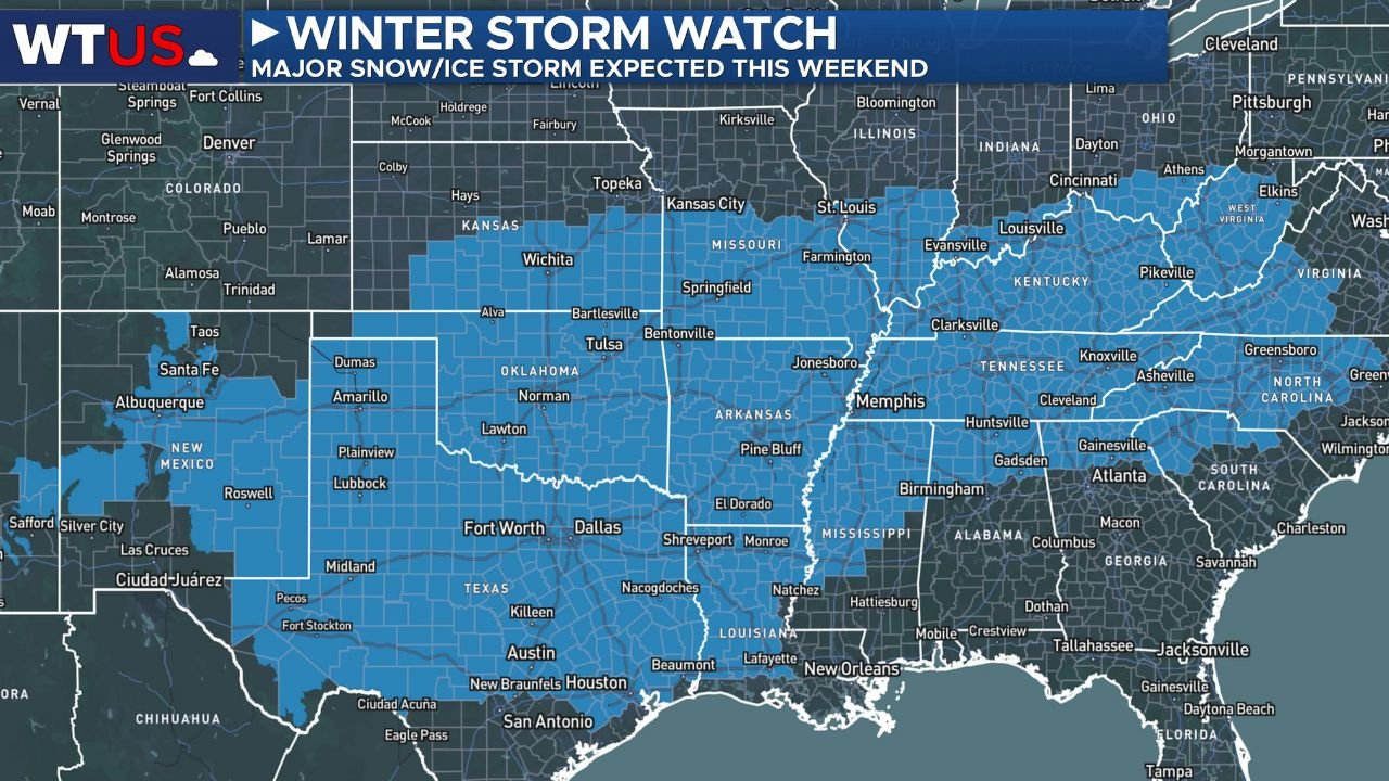
Winter Storm Watch Issued Across a Wide Multi-State Corridor
The latest Winter Storm Watch highlights a broad swath of the country now under heightened alert, including:
- Oklahoma
- Arkansas
- Missouri
- Kentucky
- Tennessee
- West Virginia
- Virginia
- North Carolina
- Maryland
These areas are expected to see multiple winter hazards, not just snow. Forecasters emphasize that snow, sleet, freezing rain, and bitter cold will overlap across many states, increasing the risk of infrastructure damage and long-term disruptions.
Heavy Snow Likely From the Southern Plains to the Appalachians
According to updated snowfall probability data, much of the storm corridor has a high likelihood of receiving more than 3 inches of snow, with some regions facing considerably higher totals once final storm tracks are locked in.
- Northern Oklahoma, northern Arkansas, and southern Missouri sit in a core snow zone where accumulation could be impactful.
- Kentucky, Tennessee, and West Virginia show strong probabilities for widespread snowfall, particularly across elevated terrain.
- Virginia, Maryland, and parts of North Carolina are likely to see accumulating snow on top of ice, compounding travel hazards.
Forecast models still show variability, but confidence is growing that this will be a high-impact snow event, especially along and north of the main storm track.
Severe Ice Threat Raises Power Outage Concerns
Equally concerning is the freezing rain potential, which spans a long east-west corridor from Texas and Arkansas through Tennessee, Kentucky, Virginia, and into North Carolina.
Current projections show a moderate to high probability of more than 0.05 inches of freezing rain, with localized areas potentially seeing higher ice accretion.
This level of ice is enough to:
- Down trees and power lines
- Cause prolonged power outages
- Make roads and bridges extremely dangerous
- Disrupt emergency response and travel for days
Residents in ice-prone zones are strongly urged to prepare for extended power loss, especially where ice overlaps with strong winds.
Major Cold Surge Will Prolong Impacts After the Storm
Behind the system, Arctic air will surge southward, locking in icy conditions well after precipitation ends. Temperatures are expected to remain well below freezing, preventing rapid melting and increasing the risk of:
- Refreezing roads
- Structural ice damage
- Burst pipes
- Extended school and business closures
In some northern areas, wind chills could plunge to dangerously low levels, posing serious health risks.
Forecast Uncertainty Remains — But Risk Is Already High
Forecasters caution that exact snowfall and ice totals are still being refined, as model guidance continues to adjust. However, the overall message is clear:
The threat is real, widespread, and potentially severe.
More precise accumulation forecasts are expected as additional atmospheric data becomes available, but residents should not wait for final numbers before preparing.
What Residents Should Do Now
If you are under a Winter Storm Watch, now is the time to prepare:
- Avoid unnecessary travel during peak storm periods
- Stock up on food, water, and medications
- Charge devices and have backup power ready
- Prepare vehicles for winter conditions
- Check on vulnerable family members and neighbors
This storm has the potential to disrupt daily life across multiple regions of the country, from the Southern Plains through the Mid-Atlantic, with impacts lingering into next week.
Stay alert for upgrades to Winter Storm Warnings and continue monitoring official local forecasts.
For continued storm coverage, safety updates, and weather alerts, follow ChicagoMusicGuide.com.