Texas, Oklahoma, Arkansas, Missouri, Tennessee, and Kentucky Face Growing Threat From Major January Winter Storm With Snow and Ice Watches Expanding
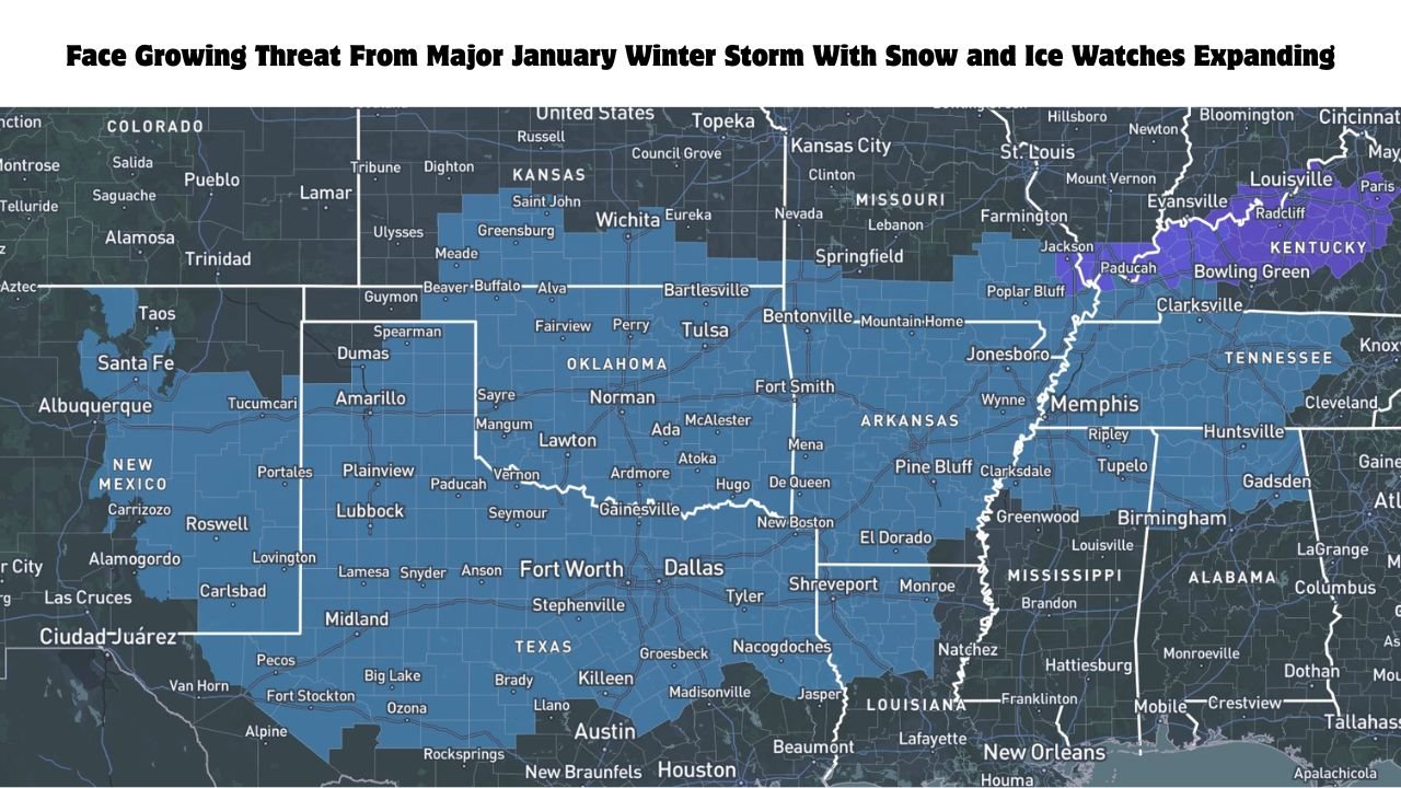
UNITED STATES — A major January winter storm is increasingly likely to impact Texas, Oklahoma, Arkansas, Missouri, Tennessee, and Kentucky, as meteorologists confirm a significant shift in forecast trends pointing toward a widespread snow and ice event. Large portions of the Southern Plains and Mid-South are now under Winter Storm Watches, with additional counties expected to be added as confidence grows ahead of a full forecast update later today.
Forecast Trend Shifts Signal a More Widespread Winter Threat
Recent model guidance has shown a notable northward trend, a change that forecasters say is not unexpected given evolving Pacific and Arctic wave patterns. This shift allows colder Arctic air to press farther south while a strong southern low-pressure system becomes more amplified.
As a result, regions that were previously on the fringe of winter impacts — including parts of north and central Texas, Oklahoma, and Arkansas — are now firmly within the zone of concern. Forecasters emphasize that this adjustment increases the likelihood of both snow and ice hazards occurring over a broader area.
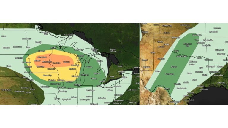
Winter Storm Watches Expand Across the Southern Plains and Mid-South
The latest maps show Winter Storm Watches in effect across wide areas of:
- Texas
- Oklahoma
- Arkansas
- Southern Missouri
- Western Tennessee
- Western Kentucky
These watches indicate a growing potential for significant winter weather, including heavy snow, sleet, and freezing rain, though exact amounts and precipitation types may still change as the system approaches.
Officials caution that additional counties are likely to be added, particularly as the forecast enters the short-range phase overnight, when details typically sharpen.
Snow and Ice Impacts Could Be Among the Most Significant in Years
Meteorologists note that this storm has the potential to become one of the most impactful multi-region winter storms seen in many years. Forecast scenarios continue to show snow, ice, and extreme cold hazards all in play, depending on exact storm track and temperature placement.
For Texas, Oklahoma, and Arkansas, freezing rain and sleet may pose the greatest concern, while areas farther north into Missouri, Tennessee, and Kentucky could see significant snowfall totals if colder air holds in place.
Travel disruptions, hazardous road conditions, and possible power outages are all considered realistic outcomes should the storm evolve as currently projected.
Uncertainty Remains as Forecast Moves Into Short-Range
Despite increasing confidence in a major storm, forecasters stress that the system is still transitioning from medium-range to short-range guidance. This means additional shifts — north or south — remain possible, even within the next 24 hours.
Importantly, experts warn that being outside the current highest-impact zone does not guarantee safety. A late trend adjustment could still pull new areas into dangerous conditions, reinforcing the need for continuous monitoring.
Residents Urged to Prepare and Stay Informed
Emergency planners encourage residents across Texas, Oklahoma, Arkansas, Missouri, Tennessee, and Kentucky to begin preparations now. This includes reviewing travel plans, checking emergency supplies, and staying updated with local forecasts and alerts.
With cold air expected to linger behind the storm, impacts may extend beyond the initial snowfall or icing, leading to prolonged hazardous conditions even after precipitation ends.
As this January winter storm threat continues to evolve, timely and accurate information will be critical. For continued updates on Winter Storm Watches, snow and ice forecasts, and regional impact analysis across the central and southern United States, visit ChicagoMusicGuide.com for the latest weather coverage.