Mississippi and Northeast Louisiana Face Crippling Ice Storm as Forecasts Show Over One Inch of Ice and Days-Long Power Outages
MISSISSIPPI AND NORTHEAST LOUISIANA — A dangerous and potentially historic ice storm is increasingly likely across large portions of Mississippi and northeast Louisiana, with updated forecasts continuing to show severe ice accumulations exceeding one inch in several communities. Meteorologists warn that this level of icing could result in catastrophic vegetation damage, widespread power outages lasting multiple days, and roadways becoming completely impassable from Friday through Monday.
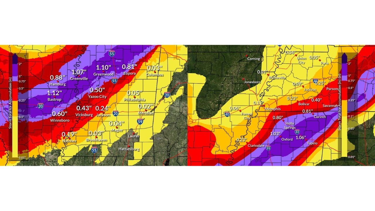
Ice Totals Exceeding One Inch Signal High-Impact Event
The latest event-total ice accumulation maps from regional forecast offices show a core corridor of extreme icing stretching across the Mississippi Delta, north-central Mississippi, and into northeast Louisiana. Several locations are now projected to see ice totals at or above one inch, a threshold that significantly increases the risk of tree failure and infrastructure damage.
Forecast highlights include:
- Greenwood, MS: ~1.10 inches of ice
- Bastrop, LA: ~1.12 inches of ice
- Oxford, MS: ~1.03 inches of ice
- Tupelo, MS: ~1.06 inches of ice
- Greenville, MS: ~1.07 inches of ice
Ice accumulations of this magnitude are rarely manageable for utility systems in the Deep South and often lead to long-duration power outages.
Communities Most at Risk for Prolonged Disruptions
Residents across northern and central Mississippi should prepare for extended isolation, especially in cities and towns directly within the highest ice zone. Communities of particular concern include Corinth, Oxford, Clarksdale, Tupelo, Holly Springs, Grenada, Greenwood, Belzoni, Indianola, and Cleveland.
Emergency officials caution that travel may be impossible for at least 72 hours in these areas, with fallen trees, downed power lines, and untreated roads preventing movement even after precipitation ends.
Vegetation Damage and Power Grid Stress a Major Concern
Ice accumulation above one inch places extraordinary stress on trees, especially those with existing structural weaknesses. Branches and entire trees are expected to fail, particularly in areas that still retain leaves or have dense canopy cover.
As trees fall, power lines and substations become highly vulnerable, increasing the likelihood of multi-day or even week-long outages in harder-hit areas. Restoration efforts may be delayed due to impassable roads and ongoing icy conditions.
Road Conditions Expected to Deteriorate Rapidly
Roadways across the region are expected to transition from wet to ice-covered in a matter of hours once surface temperatures drop below freezing. Bridges, overpasses, and rural roads will become hazardous first, followed by major highways.
Officials warn that many secondary and rural roads may not be cleared for days, making emergency access difficult and isolating entire communities.
Preparation Urged Ahead of Multi-Day Isolation
Residents in the highest-impact areas are strongly urged to prepare for at least three days without power or travel, including:
- Securing food and drinking water
- Ensuring prescription medications are available
- Charging devices and preparing battery-powered lighting
- Using safe heating sources only to avoid fire or carbon monoxide risks
Emergency planners stress that once icing begins, conditions may worsen quickly, leaving little opportunity for last-minute preparations.
Why This Ice Storm Is Especially Dangerous
What makes this event particularly concerning is not just the amount of ice, but its geographic coverage across multiple population centers. Large portions of Mississippi and northeast Louisiana sit directly under the most intense icing band, increasing the likelihood of regional-scale disruption rather than isolated impacts.
As forecasts continue to refine, confidence remains high that this will be a high-impact, long-duration winter weather event for the Deep South.
As Mississippi and northeast Louisiana brace for dangerous icing and prolonged outages, preparation and caution will be critical in the days ahead. For continued storm updates, impact analysis, and regional weather coverage, visit ChicagoMusicGuide.com.