North Carolina Braces for Major Multi-Day Snowstorm as NWS Raleigh Forecasts Up to 18 Inches in Central Regions
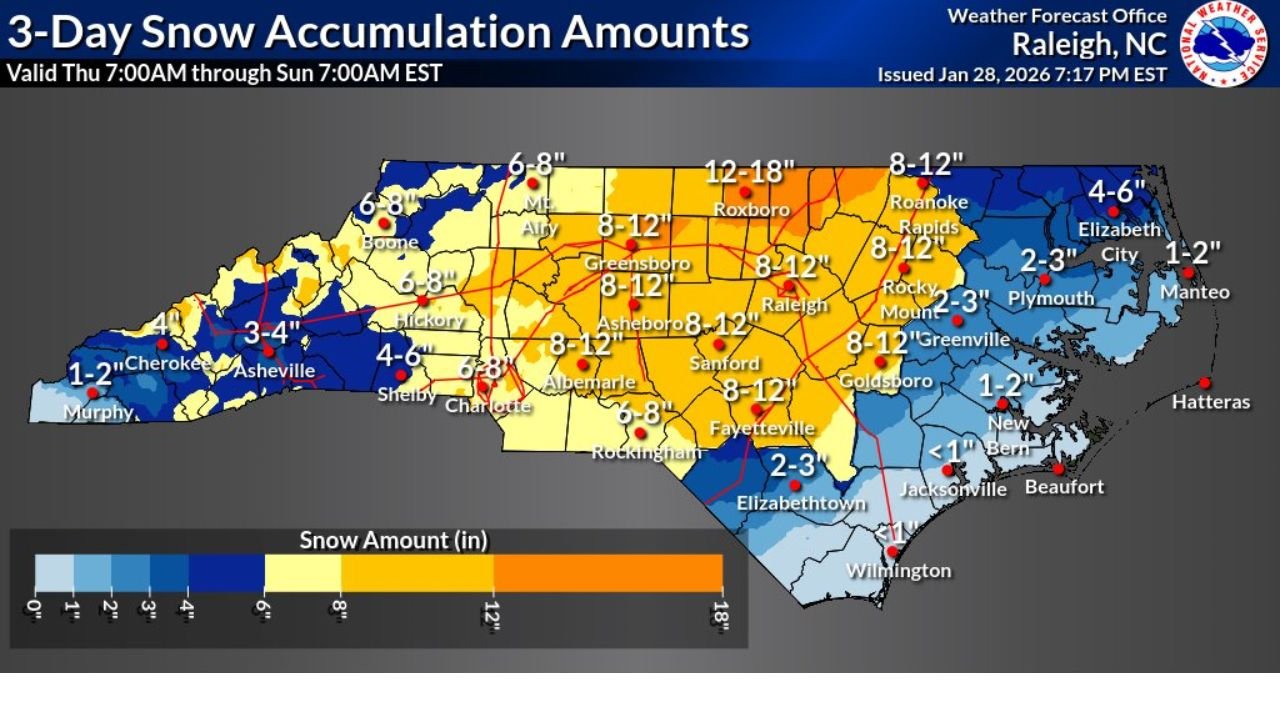
RALEIGH, NORTH CAROLINA — A major winter storm is expected to impact large portions of North Carolina over the next several days, with official snowfall projections from the National Weather Service in Raleigh indicating a prolonged and potentially high-impact event. The latest three-day snow accumulation forecast, valid from Thursday morning through early Sunday, shows widespread snow across the state with the heaviest totals concentrated in central and north-central regions.
Forecasters emphasize that this map represents the expected outcome, not a low-probability scenario, signaling increased confidence in significant snowfall totals and prolonged winter conditions.
Official NWS Raleigh Forecast Highlights a Multi-Day Snow Event
The NWS Raleigh Weather Forecast Office released updated accumulation totals late Wednesday evening, outlining snowfall expected from 7:00 a.m. Thursday through 7:00 a.m. Sunday (EST). Unlike short-duration winter events, this system is forecast to produce multiple rounds of snow, allowing totals to build steadily over several days.
Much of the state is expected to remain below freezing for extended periods, limiting melting between snow bands and increasing the likelihood of persistent snow cover, icy roads, and infrastructure stress.
Central North Carolina Expected to See the Highest Snow Totals
The heaviest snowfall is forecast across central and north-central North Carolina, where several population centers fall within the 8–12 inch range, with localized areas potentially reaching 12–18 inches if snow bands remain stationary.
Cities expected to see significant accumulation include Raleigh, Greensboro, Durham, Sanford, Asheboro, Albemarle, Roxboro, and Goldsboro. Areas just north of the Triangle appear most favorable for higher-end totals, where snowfall rates may intensify during peak periods.
For the Raleigh metropolitan area, the forecast firmly places the region in the 8–12 inch zone, a level that historically leads to widespread travel disruptions, school closures, and power concerns.
Western North Carolina and Foothills Face Moderate but Impactful Snow
In western North Carolina, snowfall totals are expected to be lower overall but still impactful. Locations such as Asheville, Boone, Hickory, Shelby, and surrounding foothill communities are forecast to receive 3–6 inches, with some higher elevations approaching 6–8 inches.
While totals here are less extreme than central regions, mountainous terrain, elevation changes, and colder surface temperatures increase the risk of dangerous travel conditions, particularly on secondary roads and mountain passes.
Eastern and Coastal North Carolina See Lower Totals but Icy Risks
Snowfall amounts decrease farther east, especially closer to the coast. Greenville, Plymouth, and Elizabeth City are forecast to receive 2–3 inches, while immediate coastal areas such as New Bern, Jacksonville, Wilmington, and Beaufort are expected to see less than 1 inch to around 1–2 inches.
Despite lighter snowfall, cold overnight temperatures may still allow for brief icy conditions, which can create outsized impacts in regions less accustomed to winter weather.
Why This Storm Is Concerning for Travel and Power Infrastructure
The primary concern with this system is its duration, not just peak snowfall. Extended snow accumulation increases the risk of:
- Tree damage and power outages from snow loading
- Prolonged hazardous travel due to repeated snowfall rounds
- Delayed emergency response times during peak periods
With several days of wintry conditions expected, even moderate additional snowfall could push some areas beyond critical impact thresholds.
What Residents Across North Carolina Should Prepare For
Officials urge residents to prepare for changing and potentially worsening conditions through the weekend. Preparations should include limiting unnecessary travel, ensuring emergency supplies are ready, and monitoring updated forecasts as snowfall bands evolve.
As North Carolina braces for one of the most significant winter setups of the season, continued monitoring will be essential as confidence increases and final snowfall totals become clearer.
For continued winter weather coverage, detailed forecast breakdowns, and regional impact updates, visit ChicagoMusicGuide.com.