North Carolina Outer Banks and Virginia Beach Face Potential Blizzard Conditions as Powerful Coastal Winter Storm Intensifies This Weekend
UNITED STATES — A rapidly intensifying coastal winter storm is taking shape just offshore of the Southeast and Mid-Atlantic, with new model guidance and National Weather Service data pointing to dangerous, near-blizzard conditions for North Carolina’s Outer Banks and the Virginia Beach area late this weekend into early Monday. The setup combines heavy snowfall, extreme wind gusts, and coastal flooding concerns, creating a high-impact scenario for exposed Atlantic shoreline communities.
Explosive Coastal Low Develops Offshore
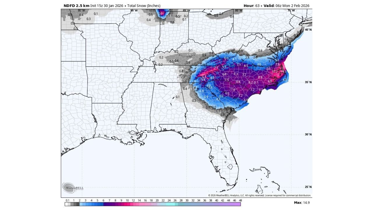
High-resolution guidance shows a deepening low-pressure system forming just off the Carolina coast, tracking northward parallel to the shoreline. This positioning is critical: it keeps the cold air locked in place inland while drawing Atlantic moisture back over sub-freezing surface temperatures. The result is a narrow but intense snow band focused along the coast, especially from eastern North Carolina into southeastern Virginia.
Meteorologists note that this type of storm track is notorious for producing wind-driven snowfall and whiteout conditions, particularly on barrier islands and coastal peninsulas.
Outer Banks: Heavy Snow and Violent Wind Gusts
Along the North Carolina Outer Banks, forecast guidance indicates 4–7 inches of snow, with locally higher amounts possible where banding persists. What makes the situation especially dangerous is the wind:
- Wind gusts up to 65 mph are possible
- Blowing and drifting snow could reduce visibility to near zero
- Snow may become compacted into dense, icy layers due to strong winds (“snowcrete” conditions)
These factors raise the risk of short-duration blizzard or near-blizzard conditions, even if snowfall totals stay within single digits.
Virginia Beach: Higher Totals, Flooding Threat
Farther north, Virginia Beach and nearby coastal communities are projected to see 6–12 inches of snow, making this one of the more significant coastal snow threats for the region in recent years. Wind gusts here could reach 60 mph, strong enough to cause power disruptions and extensive drifting.
In addition to snow and wind, coastal flooding of 1 to 3 feet is possible Sunday morning, driven by prolonged onshore flow and storm surge. This combination could make travel extremely dangerous and delay emergency response in low-lying areas.
Carolinas Inland: Sharp Gradient in Snowfall
Snowfall totals drop off quickly just inland from the coast. Interior portions of eastern North Carolina may still see several inches, but the heaviest accumulation remains tightly focused near the shoreline. This sharp gradient highlights how small shifts in storm track could significantly change local outcomes, a factor forecasters continue to monitor closely.
Maryland and Delaware Beaches: Glancing Impact
For Maryland and Delaware coastal areas, the storm appears to be more of a scrape than a direct hit. Current projections suggest 1–3 inches of snow, accompanied by wind gusts up to 50 mph. While disruptive, impacts there are expected to be less severe compared to the Outer Banks and Virginia Beach.
Why This Storm Stands Out
This event is notable not just for snowfall, but for the combination of heavy snow, extreme wind, and coastal flooding concentrated in a relatively small geographic area. Coastal winter storms of this intensity can rival tropical systems in terms of wind stress and infrastructure impact, especially on barrier islands.
What to Watch Next
Forecasters emphasize that confidence is increasing, but final snowfall totals and wind strength will depend on the exact offshore track of the low. Even a shift of 25–50 miles could dramatically alter conditions along the coast.
Residents and travelers in North Carolina’s Outer Banks and southeastern Virginia should prepare for rapidly deteriorating weather, possible road closures, ferry disruptions, and power outages as the storm reaches peak intensity late this weekend.
Stay weather-aware and follow local advisories as this high-impact coastal winter storm continues to evolve. For ongoing updates, in-depth weather breakdowns, and regional storm coverage, keep following ChicagoMusicGuide.com.