North Carolina, South Carolina and Virginia Face Potentially Historic Snowstorm as Coastal Low Explodes This Weekend

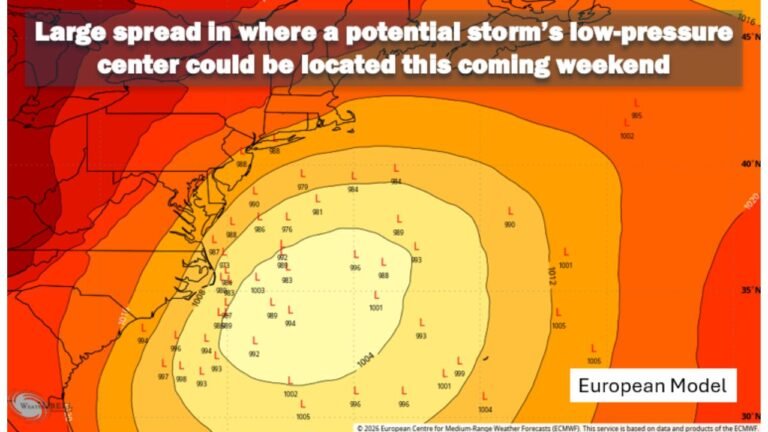
CHICAGO — A powerful and unusually cold winter storm is taking shape along the Southeast and Mid-Atlantic coast, with forecast models now pointing to a major snow event across North Carolina, South Carolina, and southeastern Virginia, including the risk of blizzard-like conditions near the coast as a rapidly intensifying coastal low develops offshore late Saturday into Sunday.
Meteorologists say this setup has the potential to become the most significant snowstorm the Carolinas have seen in more than a decade, driven by a rare combination of deep Arctic air, a diving upper-level disturbance, and a strengthening coastal low pulling Atlantic moisture inland.
Why This Storm Setup Is So Unusual for the Carolinas
Forecast guidance shows a strong TPV (Tropospheric Polar Vortex) diving southward into the eastern United States, allowing exceptionally cold air to lock into place across the Carolinas just as a coastal low forms offshore.
At the same time, model data highlights favorable frontogenetic (FGEN) forcing and deformation banding, signals that often correlate with intense snowfall rates. This dual-band structure increases confidence that parts of the region could see several hours of heavy, wind-driven snow, rather than a brief or marginal event.
This is not a typical cold-rain or mixed-precipitation system — temperatures throughout the storm remain well below freezing, even near the coast.
Expected Snowfall Totals Across the Carolinas
Latest National Weather Service snowfall projections show a wide swath of accumulating snow from eastern South Carolina into central and eastern North Carolina, with the highest totals focused inland from the immediate coastline.
Forecast snowfall amounts include:
- Central & Eastern North Carolina: 6–12 inches, with locally higher totals possible where banding persists
- Coastal North Carolina: 4–7 inches, with blowing and drifting snow
- Eastern South Carolina: 1–4 inches, highest north of Charleston
- Charleston metro area: Around 1–2 inches, potentially higher in heavier bands
- Southeastern Virginia (including Virginia Beach): 6–12 inches, with significant wind impacts
Snowfall rates may exceed 1 inch per hour at times within the strongest bands.
Blizzard-Like Conditions Possible Near the Coast
While official blizzard warnings depend on visibility criteria, near-whiteout conditions are possible, especially in coastal North Carolina and southeastern Virginia.
Forecast models indicate:
- Wind gusts of 50–65 mph near the coast
- Sustained gale-force winds
- Blowing and drifting snow reducing visibility to near zero
- Coastal flooding of 1–3 feet, particularly Sunday morning near high tide
Even areas receiving lower snowfall totals could experience dangerous travel conditions due to wind and drifting.
Travel, Power, and Safety Impacts
The Winter Storm Severity Index places parts of the Carolinas in major to extreme impact categories, signaling:
- Dangerous or impossible travel
- Widespread road closures
- Possible power outages due to wind stress
- Icy bridges and elevated roadways
With temperatures struggling to rise out of the 20s or lower 30s, any snow that falls will remain on the ground, increasing long-term impacts.
What Happens Next
The highest confidence window for significant impacts runs from late Saturday night through Sunday afternoon, with lingering snow showers possible into Sunday evening.
Residents across North Carolina, South Carolina, and southeastern Virginia should prepare for rapidly deteriorating conditions, monitor official weather alerts, and avoid unnecessary travel once snowfall begins.
Final Word
This storm is not just another winter system — it is a rare, high-impact Southeast snow event with the ingredients needed for historic snowfall and coastal wind damage. Small shifts in the storm track could still affect totals, but confidence continues to grow that a major winter storm is imminent.
For continued storm updates, forecast breakdowns, and impact tracking, stay connected with ChicagoMusicGuide.com.