Tri-State Cold Weather Advisory Brings Subzero Wind Chills as New York, New Jersey, and Connecticut Face Bitter Cold Tonight
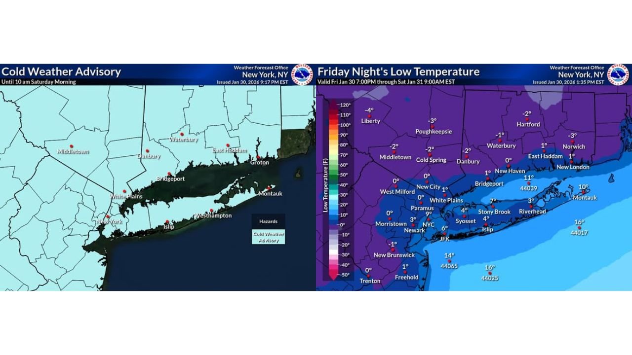
NEW YORK — Another Cold Weather Advisory is in effect across the tri-state region tonight as a surge of Arctic air pushes temperatures sharply lower. Forecast data shows overnight lows ranging from +10°F to -5°F, with strong winds making it feel significantly colder through early Saturday morning.
Arctic Air Drives Temperatures Below Freezing Across the Region
Weather maps indicate widespread subfreezing conditions across New York, New Jersey, and Connecticut as the cold settles in Friday night. Interior and northern locations are expected to be the coldest, while coastal areas remain slightly milder but still well below seasonal averages.
Several inland communities are forecast to dip below zero, especially across higher elevations and areas farther from the coast. Even major metro areas are not spared, with single-digit temperatures expected in and around urban corridors.
The cold is notable not just for its intensity, but for how widespread it is across the tri-state area.
Wind Chill Values Drop to 0°F and Below Overnight
While air temperatures are already dangerously low, wind chill is the bigger concern. Forecast wind chill maps show overnight “feels-like” temperatures ranging from 0°F down to -10°F in many locations.
Persistent northwest winds will strip heat from exposed skin quickly, increasing the risk of frostbite and hypothermia. Officials warn that even short periods outdoors late tonight or early Saturday could become dangerous without proper protection.
In the coldest spots, exposed skin could begin to freeze in as little as 30 minutes.
Saturday Remains Bitter Despite Some Daytime Warming
Although temperatures will rebound slightly on Saturday, conditions will remain harsh. Forecasts show that the warmest wind chills during the day may only reach the teens, especially in inland sections of the tri-state.
Cloud cover and lingering winds will limit how much warming occurs, keeping the cold locked in through much of the day. Nighttime conditions Saturday night are expected to remain frigid, though not as extreme as Friday night in most areas.
Residents should not assume daytime hours will bring relief from the cold.
Areas at Highest Risk During This Cold Snap
The coldest and most dangerous conditions are expected in:
- Interior New York and Connecticut
- Northern New Jersey
- Higher elevation and rural locations
- Areas away from coastal moderation
Coastal communities may see slightly higher readings, but wind exposure near open water can still create dangerous wind chills.
Safety Officials Urge Cold Weather Precautions
Emergency officials recommend taking steps to stay safe during the advisory period:
- Limit time outdoors, especially overnight and early morning
- Dress in multiple layers, including hats and gloves
- Bring pets indoors and protect exposed pipes
- Check on elderly neighbors and vulnerable individuals
Space heaters should be used carefully, and residents are urged to avoid unsafe heating methods that increase fire risk.
As the tri-state region endures another blast of midwinter cold, residents are reminded that wind chill — not just air temperature — poses the greatest danger. For continued weather alerts, cold safety updates, and regional coverage across the Northeast, visit ChicagoMusicGuide.com.