Charleston Tri-County Braces for 4–7 Inches of Snow as Coastal Winter Storm Spreads Into Southeast Georgia Overnight
CHARLESTON, SOUTH CAROLINA — A strengthening coastal winter storm is expected to deliver significant snowfall across the Charleston Tri-County area overnight into Sunday morning, with the National Weather Service forecasting totals as high as 4 to 7 inches in parts of the region. Lighter but notable snow accumulations are also expected farther south into southeast Georgia, marking a rare and impactful winter weather event for the coastal Southeast.
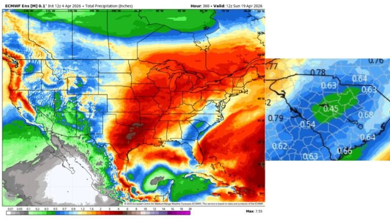
Heaviest Snow Focused on the Charleston Tri-County Area
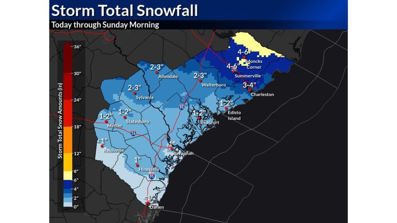
According to the latest NWS Charleston snowfall forecast, the highest snow totals are expected across Berkeley, Charleston, and Dorchester counties, where bands of heavier snow may persist through the overnight hours.
Forecast maps indicate:
- 4–6 inches across parts of Summerville and Moncks Corner
- 3–4 inches possible in the Charleston metro area
- 2–3 inches extending inland toward Walterboro, Allendale, and Sylvania
Meteorologists note that localized bands could push totals toward the upper end of the forecast range, especially where snowfall remains steady for several hours.
Snowfall Gradually Decreases South Into Southeast Georgia
South of the South Carolina border, snow totals are expected to taper off but remain impactful given the region’s limited winter weather experience.
Forecast snowfall amounts include:
- 1–2 inches across Statesboro and Metter
- Around 1 inch near Hinesville and Savannah
- Up to 1 inch or less south of Interstate 16, including areas near Darien
While accumulations will be lighter in Georgia, even small amounts of snow could cause slick roadways and travel disruptions, especially during the overnight and early morning hours.
Timing: Overnight Snow Into Sunday Morning
Snow is expected to continue through the overnight hours, with the most persistent snowfall occurring late Saturday night into early Sunday morning. The storm is forecast to gradually wind down from west to east, with snow ending by mid to late Sunday morning for most areas.
Cold surface temperatures will allow snow to accumulate efficiently on roads, bridges, and elevated surfaces, increasing the risk of hazardous travel conditions.
Travel Impacts and Safety Concerns
With snowfall rates occasionally increasing and temperatures remaining cold, road conditions are expected to deteriorate quickly, particularly in the Charleston metro area and along coastal corridors.
Officials urge residents to:
- Avoid unnecessary overnight travel
- Use caution on bridges and overpasses
- Allow extra time for Sunday morning travel
Even areas receiving lower totals may experience reduced visibility and slick conditions, especially before sunrise.
A Rare Coastal Snow Event for the Southeast
Snowfall of this magnitude is unusual for coastal South Carolina and southeast Georgia, making this event particularly impactful despite totals that would be considered moderate in colder climates.
As the storm continues to unfold, residents are encouraged to monitor updates and remain prepared for rapidly changing conditions overnight.
For continued coverage of winter storms, snowfall forecasts, and regional weather impacts across the U.S., visit ChicagoMusicGuide.com.