New York Braces for February Cold as Lake Ontario Snow Brings Flurries to Buffalo, Rochester, and Watertown
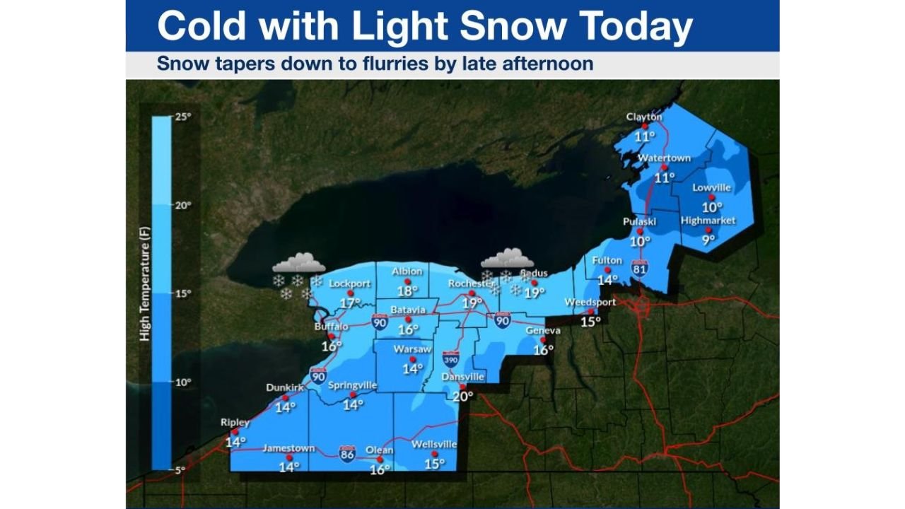
NEW YORK — February is opening with another punch of winter across upstate New York as cold northwest winds over Lake Ontario trigger light lake-effect snow, keeping temperatures locked well below normal and adding fluffy snow along the shoreline from Buffalo to Watertown.
According to the latest early-morning outlook, a northwest flow of Arctic air is moving across the lake today, producing periods of light snow near the southern Lake Ontario shoreline, while areas farther inland see little more than flurries. The snow activity is expected to gradually weaken through the afternoon, tapering off by early evening as the cold air mass begins to settle.
Light Snow Focused Along the Lake Ontario Shoreline
Forecasters say the setup favors lake-effect enhancement, meaning communities closest to the lake will see the most impact. Cities including Buffalo, Rochester, Oswego, Watertown, and surrounding shoreline towns may pick up an additional 1 to 3 inches of light, fluffy snow before activity fades.
Farther south — including areas south of the New York State Thruway — snowfall totals drop off quickly, with an inch or less expected inland. The lack of deeper moisture and weakening instability should prevent heavier snow bands from developing.
Cold Temperatures Keep Snow Powdery
High temperatures today struggle to escape the teens across much of western and central New York. In some northern areas near Lake Ontario, afternoon highs may hover between 10 and 15 degrees, keeping snow dry and powdery.
Winds out of the northwest will add a bite, making it feel even colder during the morning hours before gradually easing later in the day. While travel impacts are expected to remain minor, untreated roads near the shoreline could become slick during periods of snow.
Why This Snow Won’t Last Long
This lake-effect setup is short-lived. As high pressure begins building in from the west, wind direction becomes less favorable for sustained snow bands. Without stronger cold air or additional moisture, snow showers will fade into scattered flurries by late afternoon, ending entirely by evening for most locations.
Despite the limited snowfall, the bigger story remains the persistent cold, which continues to grip the region as February begins — reinforcing that winter is far from finished across the Northeast.
What to Expect Tonight
Once the snow ends, skies partially clear, allowing temperatures to drop quickly after sunset. Overnight lows are expected to fall back into the single digits, especially inland and north of the Thruway, keeping wind chills uncomfortable through Monday morning.
Have you seen snow where you are today? Are conditions worse near the lake or farther inland? Share your weather photos, snowfall totals, and cold-weather experiences with us, and stay connected with ChicagoMusicGuide.com for continued winter weather updates across the U.S.