Minnesota and Western Wisconsin Face Prolonged Light Snow Today as Gusty Winds Reduce Visibility Across the Region
MINNESOTA — Light snow will continue across much of Minnesota today, with the most persistent snowfall expected during the morning hours before gradually tapering off from west to east through the afternoon. While snowfall totals are modest, gusty northwest winds will create periods of blowing snow and reduced visibility, especially across western Minnesota and open rural areas.
According to the latest forecast, this system will not bring a major accumulation event, but its long duration and wind impact could still affect travel and outdoor plans across the region.
Snowfall Totals Remain Light but Widespread
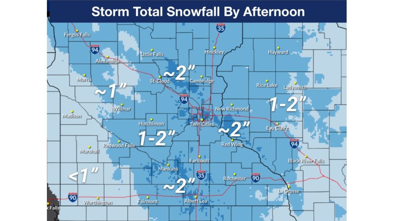
Forecast guidance indicates most of Minnesota will pick up between 1 and 2 inches of snow, with localized variations depending on timing and wind exposure.
Key snowfall ranges include:
- Central Minnesota and the Twin Cities metro: around 1 to 2 inches
- Southern and southeastern Minnesota: closer to 2 inches
- Western Minnesota: less than 1 inch in some areas
- Western Wisconsin: generally 1 to 2 inches, extending into the afternoon
Cities such as St. Cloud, Mankato, Albert Lea, Red Wing, and the Twin Cities are expected to remain within that 1–2 inch range by the time snow winds down later today.
Timing: Steadiest Snow Before Daybreak, Gradual Taper This Afternoon
The heaviest and most consistent snowfall occurred during the pre-dawn and early morning hours, with lighter snow and flurries continuing into early afternoon.
Snowfall is expected to end first in western Minnesota, then gradually push eastward through:
- Central Minnesota by early afternoon
- The Twin Cities metro by mid- to late afternoon
- Western Wisconsin by late afternoon or early evening
By tonight, most areas should be dry, though lingering clouds and cold temperatures will remain.
Gusty Winds Create Blowing Snow and Visibility Issues
Even with relatively light accumulation, northwest winds will be the primary concern today.
Wind gusts will be strong enough to:
- Cause blowing snow in open and rural areas
- Create brief reductions in visibility, particularly on east-west roadways
- Make driving conditions feel worse than totals alone suggest
Western Minnesota is most vulnerable to these impacts, where open farmland allows snow to drift and visibility to drop quickly during gusts.
Cold Temperatures Keep Snow Powdery
Temperatures remain cold enough to keep snow light and fluffy, making it easier for winds to pick it up and transport it across roadways. Highs today generally stay in the teens to lower 20s, reinforcing winter travel concerns despite lower totals.
What to Expect for Travel and Daily Plans
While this is not a major winter storm, residents should still prepare for:
- Slower travel during the morning commute
- Patchy slick spots where snow accumulates or blows back onto roads
- Reduced visibility in exposed areas through early afternoon
Conditions should gradually improve later today as snow tapers off and winds ease.
Looking Ahead
This system moves out later today, but cold winter conditions remain locked in across the Upper Midwest. Additional weak systems may bring occasional flurries later this week, though no significant snow events are currently indicated in the immediate forecast window.
Are you seeing blowing snow or slick roads in your area today? Share your local conditions and stay updated with regional winter weather coverage at ChicagoMusicGuide.com, where we track weather impacts across the Midwest in real time.