North Carolina Braces for Potentially Historic Snowstorm as Models Show 15–18 Inches in Eastern Counties
NORTH CAROLINA — A powerful winter storm forecast for January 30 through February 1, 2026, is shaping up to be one of the most significant snow events North Carolina has seen in years, with early projections showing widespread heavy snowfall and localized totals approaching record levels across large portions of the state.
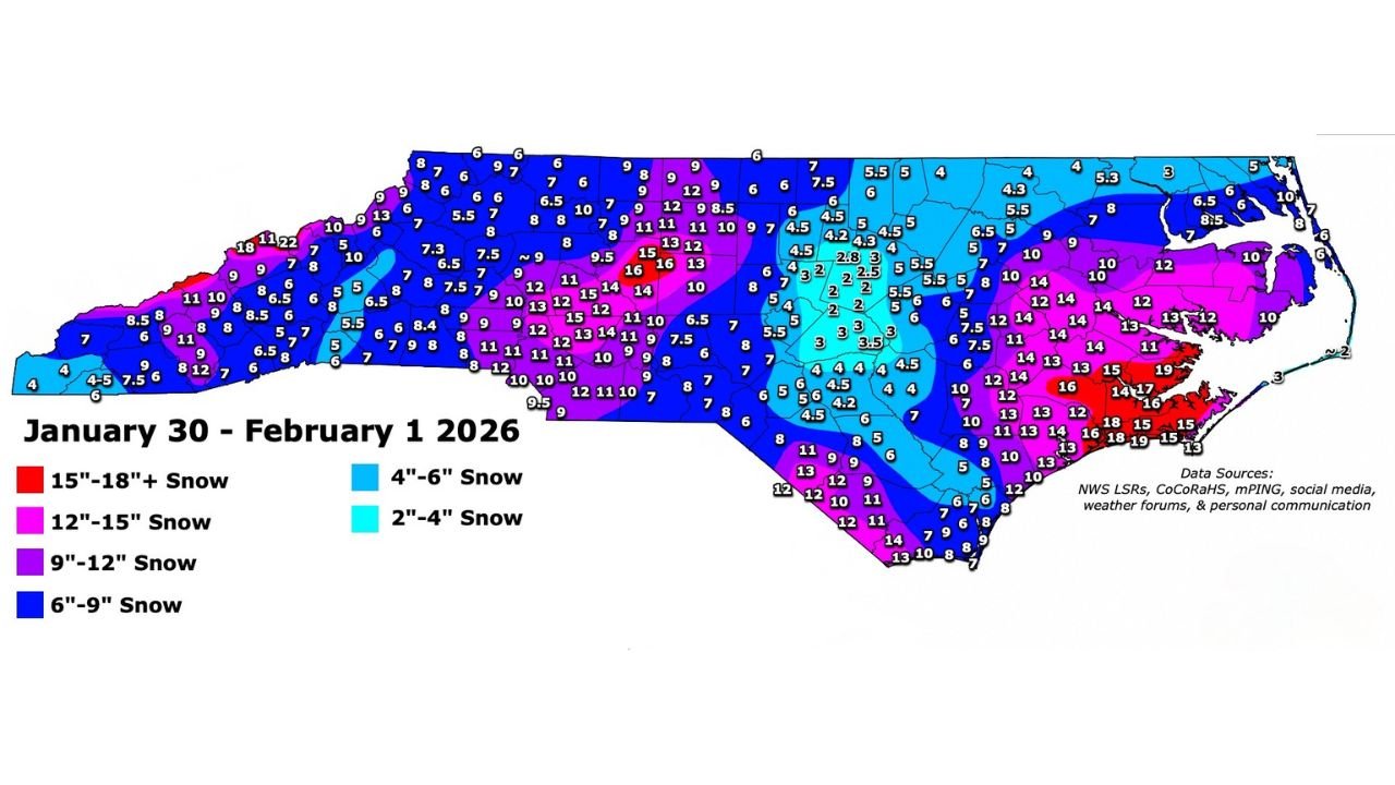
Preliminary accumulation data indicates nearly all of North Carolina could see measurable snow, with sharp gradients between central, eastern, and coastal counties. Meteorologists caution that while exact totals may still shift, confidence is growing that this storm will have major travel, infrastructure, and event impacts statewide.
Forecast Overview Shows Widespread High-Impact Snow
Early analysis highlights a classic cold-air setup across North Carolina, allowing snow to fall over a broad region rather than being confined to the mountains. Much of the Piedmont and eastern half of the state is expected to remain cold enough to support all or mostly snow throughout the event.
Current projections show a large swath of 6–9 inches of snow stretching from western Piedmont counties through central North Carolina. This alone would represent a high-impact winter storm for areas that typically see lighter accumulations.
What has drawn particular attention is the signal for double-digit snowfall totals across central and eastern sections of the state, including areas that rarely experience prolonged snow cover.
Heaviest Snow Targeted Across Central and Eastern North Carolina
According to the mapped data, a corridor of 9–12 inches of snow is possible from parts of the central Piedmont into eastern counties. Within this zone, several localized maxima show 12–15 inches, with some pockets potentially exceeding that range.
The most concerning area appears to be eastern North Carolina, where a narrow band shows 15–18 inches or more of snow. If these numbers verify, portions of eastern counties could experience historic snowfall totals rarely seen in that region.
Coastal counties may see slightly lower totals due to marginal temperatures, but even there, 8–14 inches is being indicated in several locations—an amount capable of causing widespread power outages and coastal transportation shutdowns.
Mountains and Foothills Still See Significant Totals
While the spotlight is on central and eastern North Carolina, the mountains and foothills are also forecast to receive substantial snowfall. Most western counties are projected to see 6–9 inches, with isolated higher amounts in elevated terrain.
This would add to ongoing winter conditions in the higher elevations and could lead to dangerous mountain travel, especially along secondary roads and higher passes.
The widespread nature of the storm means no part of North Carolina is entirely spared, reinforcing the potential for statewide disruption.
Timing and Duration Increase Impact Risk
The storm is expected to unfold over a multi-day window, beginning late January 30 and continuing through February 1. This prolonged duration raises the risk of snow accumulation on untreated roads, even in urban areas where snow typically melts quickly.
Overnight snowfall rates could become heavy at times, especially within the central and eastern snow bands. If snowfall rates exceed 1 inch per hour, visibility and road conditions could deteriorate rapidly.
Cold temperatures following the storm may allow snow to linger for several days, increasing the risk of refreeze and prolonged impacts to daily life.
Travel, Power, and Event Disruptions Likely
Given the projected totals, travel disruptions across North Carolina are highly likely, particularly along major corridors connecting the Piedmont to the coast. Airports, highways, and rail operations may face delays or temporary closures.
Heavy, wet snow—especially in eastern counties—raises the risk of tree damage and power outages, particularly where snowfall exceeds one foot. Emergency managers may need to prepare for extended restoration efforts in harder-hit areas.
Outdoor events, concerts, and weekend plans across the state could face cancellations or postponements, depending on how the storm evolves.
Forecast Still Subject to Refinement
Meteorologists emphasize that this remains a preliminary forecast, and small shifts in storm track or temperature profiles could significantly affect final snowfall totals. However, the consistency of heavy snow signals across multiple regions suggests the threat is real and increasing.
Residents across North Carolina are encouraged to monitor forecast updates closely over the coming days, especially as more detailed county-level guidance becomes available.
As North Carolina prepares for what could become a once-in-a-decade winter storm, early awareness will be key to staying safe and minimizing disruption. For continued weather updates, storm impact analysis, and regional alerts affecting travel and live events, visit ChicagoMusicGuide.com for the latest coverage.