Texas, Oklahoma, Arkansas, and Louisiana Emerge as Early Spring Signals Point to Mid-February Severe Weather and Supercell Potential
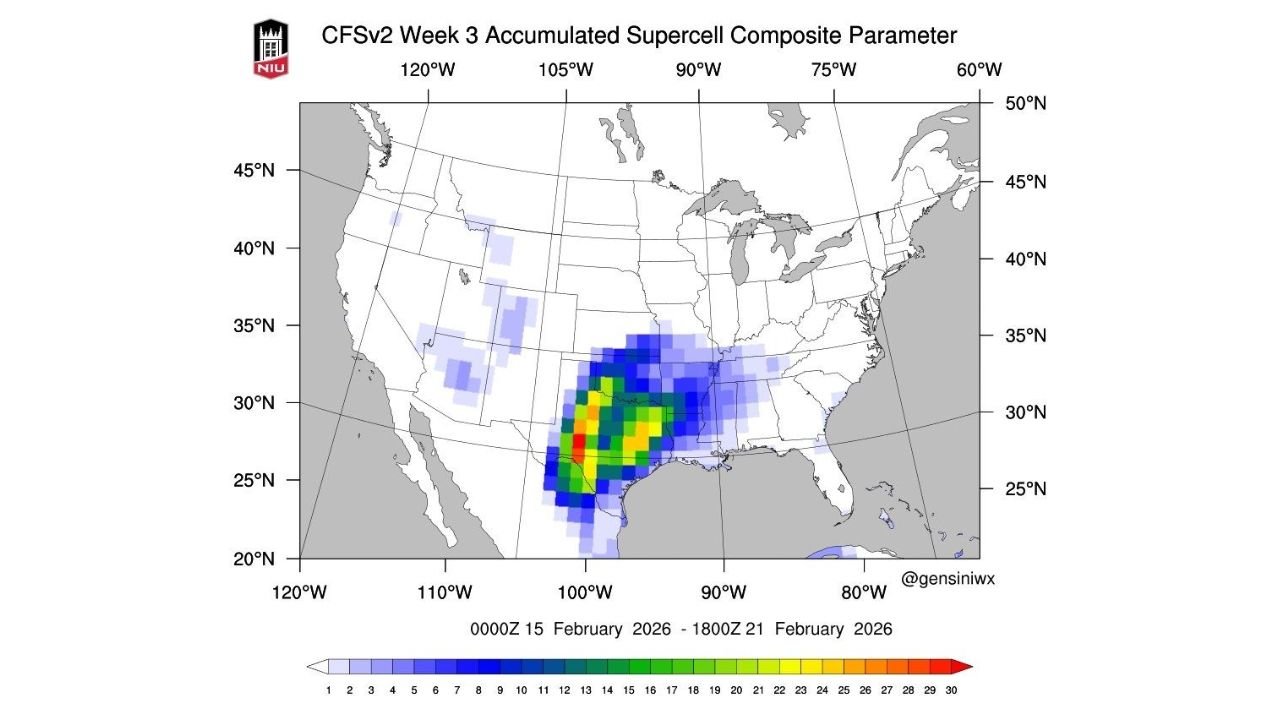
UNITED STATES — Long-range forecast models are beginning to show early signs of spring-like weather patterns, with growing indications that severe thunderstorms and supercell activity could develop across parts of the Southern Plains and Lower Mississippi Valley by mid-February 2026. New guidance from the CFSv2 Week 3 Accumulated Supercell Composite Parameter highlights a notable corridor of elevated severe weather potential stretching from Texas into Oklahoma, Arkansas, and portions of Louisiana.
While this signal does not guarantee outbreaks, meteorologists note that the pattern is consistent with seasonal transitions, where winter cold retreats and warm, moist Gulf air begins interacting more frequently with lingering upper-level disturbances.
CFSv2 Models Point to Rising Supercell Potential
The CFSv2 Week 3 outlook, covering the period from February 15 through February 21, shows a concentrated area of higher supercell composite values centered over central and eastern Texas, extending northward into southern Oklahoma and eastward toward Arkansas and northern Louisiana.
The most pronounced signals appear across north-central Texas, including areas near the Red River Valley, where model output suggests an environment supportive of rotating thunderstorms. Lesser but still notable signals extend into the Lower Mississippi Valley, hinting at broader regional instability.
Meteorologists caution that composite parameters represent environmental favorability, not confirmed storms, but the clustering of higher values in this region is a classic early indicator of springlike severe weather setups.
Why Mid-February Is Showing a Shift Toward Spring
This emerging signal reflects a potential shift in the large-scale atmospheric pattern. As Arctic air retreats northward, stronger southerly flow from the Gulf of Mexico can transport warmer, moisture-rich air inland, increasing instability across the Southern Plains.
At the same time, lingering upper-level troughs moving through the western and central United States can provide the lift and wind shear necessary for organized convection. When these ingredients overlap, the risk for supercell thunderstorms increases — even before the traditional spring severe season begins.
This type of setup is not uncommon in late February, but the clarity of the signal this early has caught the attention of forecasters monitoring seasonal transitions.
Regions to Watch Closely
The highest-risk corridor highlighted by the models includes:
- Texas, particularly central and eastern portions
- Oklahoma, mainly the southern half
- Arkansas and nearby areas of the Lower Mississippi Valley
- Portions of Louisiana near the Gulf Coast
These regions historically serve as the early-season gateway for spring severe weather, especially when Gulf moisture returns ahead of schedule.
Farther east, weaker signals extend toward the Southeast, suggesting that the broader pattern could expand if conditions align closer to the forecast window.
What This Means — and What It Doesn’t
Forecasters stress that Week 3 guidance carries uncertainty, especially when predicting mesoscale storm development weeks in advance. This outlook does not mean severe storms are guaranteed, nor does it specify exact dates or locations.
However, the signal does suggest that the atmosphere may be becoming increasingly supportive of spring-style convection, marking a notable contrast to the Arctic outbreaks that dominated earlier February forecasts.
For weather enthusiasts and emergency planners alike, this is a pattern worth monitoring, especially if future model runs continue to reinforce the signal.
A Seasonal Turning Point May Be Approaching
As winter slowly loosens its grip, the first atmospheric hints of spring are beginning to appear. While cold snaps and winter storms can still occur later in February, the growing supercell signal underscores how quickly the pattern can evolve during seasonal transitions.
Meteorologists will continue refining the forecast as shorter-range models come into focus, helping determine whether this signal translates into actual severe weather threats or fades with time.
For continued updates on severe weather outlooks, seasonal transitions, and long-range forecast trends across the United States, visit ChicagoMusicGuide.com for the latest weather coverage.