Brutal Arctic Weekend Brings Accumulating Snow and Double-Digit Below-Zero Wind Chills to New York State From Buffalo to Rochester and Oswego
UNITED STATES — A brutally cold arctic air mass moving into the Eastern United States will bring a dangerous combination of accumulating snowfall, strong northwest winds, and life-threatening wind chills to large portions of New York State from Friday night into Saturday. Forecast data shows snow squalls developing as bitter cold air pours in, with wind chills plunging into the double digits below zero and visibility rapidly deteriorating in areas where snow bands persist.
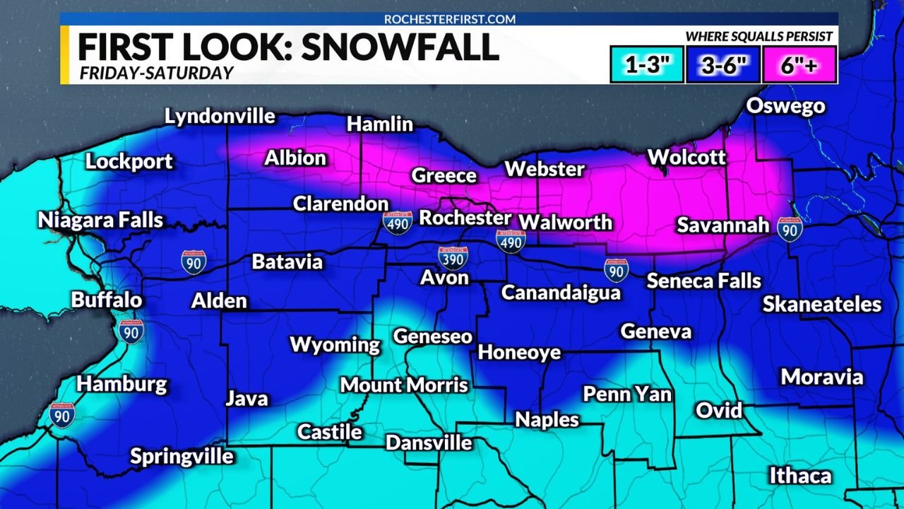
First Look at Snowfall Friday Night Into Saturday
Early snowfall projections indicate accumulating snow across western and north-central New York, with totals varying significantly depending on where snow squalls persist longest. Forecast maps show:
- 1–3 inches for much of western and interior New York
- 3–6 inches in localized corridors across Monroe, Orleans, Wayne, and Oswego counties
- 6 inches or more possible in narrow bands where snow squalls repeatedly impact the same areas
Cities and towns including Buffalo, Rochester, Greece, Webster, Walworth, Albion, Oswego, and nearby Lake Ontario shoreline communities appear most vulnerable to higher totals if lake-enhanced snow bands become established.
Forecasters caution that this is an early estimate, with higher-resolution models expected to refine snowfall placement over the next 24 hours.
Arctic Air Arrives Regardless of Snow Totals
While snowfall amounts remain subject to change, forecasters stress that Friday night and Saturday will be rough no matter how much snow falls. A surge of bitingly cold air will overspread the region, sending temperatures sharply downward behind the front.
Even areas receiving lighter snowfall will still experience dangerous winter conditions, as arctic air combines with strong winds to create a hostile outdoor environment.
Strong Northwest Winds to Whip Snow and Reduce Visibility
Behind the front, gusty northwest winds will intensify, blowing snow across open areas and roadways. These winds will whip falling and newly fallen snow, causing sudden drops in visibility—especially during snow squalls.
This setup raises concerns for blowing and drifting snow, rapidly changing travel conditions, and difficult driving during overnight hours and into Saturday morning, particularly near Lake Ontario and along exposed road corridors.
Dangerous Wind Chills Drop Into Double Digits Below Zero
The most serious threat from this system will be extreme wind chills. Forecast guidance shows wind chill values dropping well below zero, with double-digit negative wind chills likely across much of western and north-central New York.
At these levels, frostbite can occur in as little as 10–20 minutes, especially on exposed skin. Gusty winds will dramatically accelerate heat loss, making even short periods outdoors dangerous.
Why This Weekend Will Be Especially Hazardous
This event combines three dangerous elements at once:
- Accumulating snow
- Strong winds
- Severe cold
Together, these conditions create a high-impact winter scenario with risks extending beyond travel into health, infrastructure, and power reliability. Reduced visibility, wind-driven snow, and extreme cold make this a particularly dangerous setup compared to a typical winter snow event.
Travel and Event Impacts Across New York
Travel Friday night into Saturday could become hazardous quickly, especially during snow squalls when visibility drops suddenly. Roads may appear manageable one moment and dangerous the next.
For those planning concert travel, late-night events, or weekend activities across Buffalo, Rochester, Oswego, and surrounding communities, conditions may deteriorate rapidly after sunset Friday. Delays, cancellations, and safety concerns are possible as cold and wind intensify.
Cold Weather Safety Precautions Strongly Recommended
Anyone heading outdoors Friday night through the weekend should dress in multiple loose-fitting layers, including:
- A moisture-wicking base layer
- An insulating middle layer such as fleece or wool
- A windproof, waterproof outer shell
All exposed skin should be covered with hats, gloves, scarves, and insulated boots. Hands, ears, nose, and cheeks are the most vulnerable to frostbite.
Limiting time outdoors and preparing for rapidly changing conditions will be critical.
As winter tightens its grip on New York, staying informed will be essential. For continued weather updates, snow impact coverage, and how extreme conditions could affect travel and live events, visit ChicagoMusicGuide.com.