Unseasonable Warmth and Active Storm Pattern Could Raise Severe Weather Risks Across Texas, Oklahoma, Kansas, Missouri, and the Midwest by February 13–19
UNITED STATES — Long-range forecast guidance is signaling a notable pattern shift across the Central and Eastern United States as mid-February approaches, with unseasonable warmth expanding northward and an increasingly active storm track taking shape. Data from extended-range EURO-AIFS vorticity projections highlights February 13 and February 19 as key windows to watch, particularly for Texas, Oklahoma, Kansas, Missouri, and surrounding Plains and Midwest states.
While this remains an early, conceptual look, the pattern shown is one that meteorologists flag as worth monitoring closely due to its historical association with severe weather outbreaks.
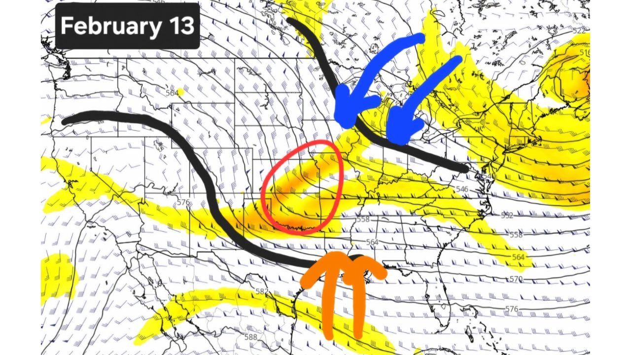
February 13 Pattern: Warm Air Surges Into the Central Plains
Forecast imagery for February 13 shows a pronounced southwest-to-northeast jet stream orientation, allowing warm, unstable air from the Gulf region to surge northward into the Southern and Central Plains.
Highlighted areas include:
- North and Central Texas
- Oklahoma
- Kansas
- Western Missouri
This setup places a corridor of enhanced atmospheric energy over the region, where rising motion and wind shear could support organized storm development if surface conditions align. The juxtaposition of warm air to the south and stronger upper-level flow to the north is a classic ingredient in active spring-like weather patterns—especially unusual for mid-February.
February 19 Pattern: Warmth Expands East and North
By February 19, ensemble guidance suggests the warm sector may expand farther east and north, pushing into:
- The Midwest
- Parts of the Ohio Valley
- Potentially the Lower Great Lakes region
The jet stream appears more zonally active during this period, indicating repeated disturbances moving through the same general corridor. This raises concerns not just for isolated storms, but for a multi-day active weather stretch, depending on how moisture return and surface boundaries evolve.
Why Meteorologists Are Watching This Setup Closely
The concern is not based on a single storm signal, but on the overall atmospheric configuration:
- Persistent unseasonable warmth
- Strong upper-level wind flow
- Repeated storm impulses
This type of pattern can increase severe weather potential across the Plains, especially if Gulf moisture returns efficiently. While exact hazards cannot yet be defined, this is the kind of setup that can support strong thunderstorms, and in some cases severe weather, earlier than climatology would normally suggest.
Still a Rough Sketch — Confidence Will Improve Soon
Forecasters stress that this is still a rough sketch, not a locked-in forecast. Higher-resolution models will begin resolving this pattern more clearly over the next several days, allowing meteorologists to determine:
- Whether instability becomes sufficient for severe storms
- How far north warm air can push
- Where the most active storm corridor ultimately sets up
At this stage, the takeaway is pattern recognition, not certainty.
Potential Impacts Beyond Severe Weather
Even if severe storms do not materialize, unseasonable warmth followed by active systems can still bring:
- Rapid temperature swings
- Heavy rain events
- Strong gradient winds
- Travel and outdoor event disruptions
For regions transitioning out of winter, these sharp changes can catch communities off guard.
What to Watch Going Forward
Residents and travelers across Texas, Oklahoma, Kansas, Missouri, and the Midwest should stay alert for forecast updates as mid-February approaches. The evolving pattern suggests February 13 through February 19 could be an unusually dynamic stretch of weather for the central U.S.
For continued long-range forecast analysis, weather pattern breakdowns, and updates that could impact travel, concerts, and live events nationwide, stay connected with ChicagoMusicGuide.com.