Arctic Blast Slams Pennsylvania, New York, Ohio, Maryland and Washington D.C. With Dangerous Wind Chills, Snow Squalls and Power Outage Risk
UNITED STATES — A powerful Arctic outbreak is set to surge across large parts of the Eastern United States this weekend, bringing a sharp temperature crash, dangerous wind chill values, snow showers, and damaging wind gusts across Pennsylvania, New York, Ohio, Maryland, New Jersey, Virginia, West Virginia, and Washington D.C. Forecast guidance shows temperatures falling 30 to 40 degrees in some areas as a strong Arctic front sweeps west to east late Friday into Saturday.
Arctic Front Timing and Rapid Temperature Drop
Forecast data shows the Arctic front arriving Friday afternoon into Friday night, pushing bitterly cold air across the Mid-Atlantic and Northeast. Temperatures that hover near freezing on Thursday and reach the low to mid-30s Friday will plunge quickly once the front passes.
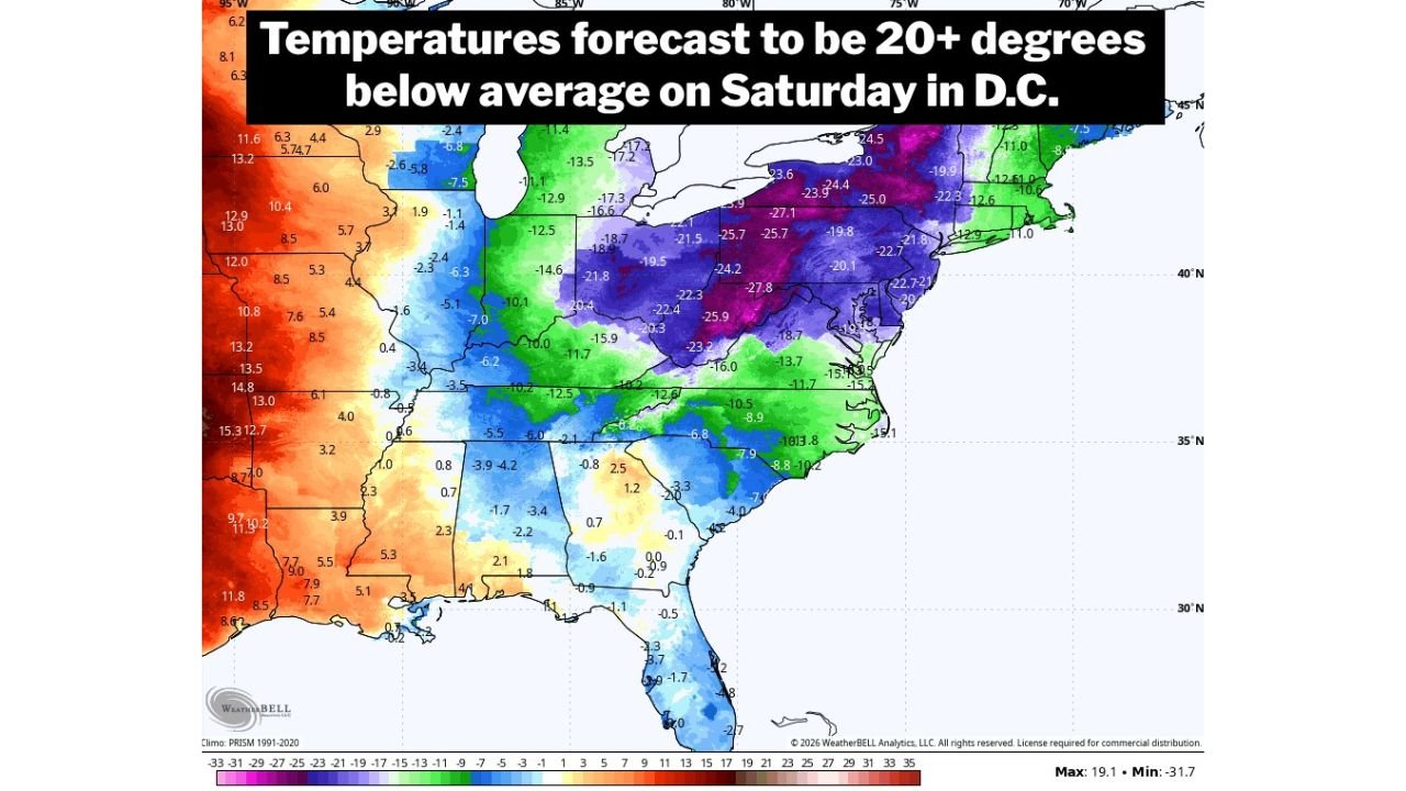
By early Saturday, much of Pennsylvania, Ohio, western New York, and Maryland will be locked into a much colder air mass, with daytime readings struggling to climb out of the 20s. Overnight lows by Saturday night into Sunday morning are expected to fall into the single digits and teens, with some locations approaching near-zero temperatures.
Dangerous Wind Chill Values Expected Overnight
As the Arctic air pours in, strong northwest winds will dramatically worsen conditions. Forecast wind gusts of 25 to 35 mph, with locally higher gusts, will push wind chill values into dangerous territory.
Across much of Pennsylvania, wind chills late Friday night into Saturday morning are forecast to fall into the negative teens and 20s below zero, especially across western and northern portions of the state. Central and eastern Pennsylvania, including areas near Harrisburg, State College, and Scranton, are expected to see wind chills ranging from 10 below to near zero, with little improvement through Saturday night.
Snow Showers and Brief Heavy Bursts Possible
While snowfall amounts are not expected to be widespread or extreme, the incoming Arctic front may produce scattered snow showers, especially Friday evening into early Saturday. These snow showers will be hit-or-miss, but some could briefly turn heavy.
Areas northwest of major metro corridors, including portions of western and central Pennsylvania and western New York, may see quick coatings of snow, particularly where snow squalls persist. Blowing snow will further reduce visibility as strong winds whip freshly fallen snow around.
Wind Gusts Could Reach 40–50 MPH
Wind is expected to be one of the most impactful elements of this system. After the front passes, gusts of 40 to 50 mph are possible late Friday night through Saturday, particularly across Pennsylvania, Maryland, northern Virginia, and New Jersey.
These wind speeds increase the risk of isolated to scattered power outages, especially where trees or power lines are already vulnerable. The National Weather Service is expected to issue wind advisories and possible warnings for parts of the region as confidence increases.
Weekend Conditions Remain Brutal Into Sunday
Saturday will remain brutally cold, with highs generally stuck between 20 and 25 degrees across much of the Mid-Atlantic and Northeast. Winds will remain strong enough to keep wind chills in the single digits to near zero for much of the day.
By early Sunday, wind chills near minus 5 degrees are possible in and around Washington D.C., with similarly dangerous conditions across Pennsylvania, Ohio, and New York. While winds may slowly ease later Sunday, cold air will remain firmly in place.
Looking Ahead: Pattern Remains Active Into Mid-February
Long-range model guidance suggests this Arctic intrusion may not be the last. Forecast trends show continued pattern volatility into mid-February, with additional cold shots and storm potential possible across the central and eastern United States. Some guidance even hints at unseasonable warmth and stronger storm systems later in the month, underscoring the unstable nature of the overall pattern.
Safety Concerns and Precautions
With wind chills dropping well below zero in many locations, frostbite can occur on exposed skin in as little as 30 minutes. Residents are urged to limit time outdoors, wear multiple insulating layers, and protect exposed skin. Gusty winds combined with snow showers may also create hazardous travel conditions, especially during overnight and early morning hours.
Stay connected with ChicagoMusicGuide.com for continued weather updates, forecast refinements, and regional impact breakdowns as this Arctic blast unfolds across the Eastern United States.