Arctic Blast Targets New England as Vermont, Massachusetts, and Maine Face Snow, Dangerous Winds, and Subzero Wind Chills Feb 6–7
UNITED STATES — A powerful Arctic front is set to surge through the Northeast late Friday into Saturday, February 6–7, bringing a volatile mix of snow showers, intense wind gusts, and some of the coldest air of the season across parts of Vermont, Massachusetts, New Hampshire, and Maine, with impacts stretching down toward coastal New England.
Meteorologists say the setup is tricky, but confidence is increasing that this system will deliver both disruptive winds and sharply colder temperatures, with select areas also seeing plowable snowfall depending on where key mesoscale features set up.
Timing of the Arctic Front and Initial Snow Showers
Forecast data shows the Arctic front pushing through Friday afternoon and evening, roughly between 1 p.m. and 10 p.m., sweeping from west to east across New England.
As the front moves through, scattered snow showers are expected. While coverage will be hit-or-miss, some bands could briefly turn heavy, especially north and west of major metro corridors, leading to quick coatings on roads and untreated surfaces before colder air crashes in.
Strong Winds May Be the Biggest Threat
While snow will grab attention, wind appears to be the dominant impact with this system.
Behind the front, northwest wind gusts of 40–50 mph are likely late Friday night into Saturday morning across wide portions of New England, including:
- Interior Massachusetts
- Southern and central New Hampshire
- Coastal Maine
- Higher elevations of Vermont
These wind speeds are strong enough to down tree limbs, cause isolated to scattered power outages, and significantly reduce visibility during any snow showers.
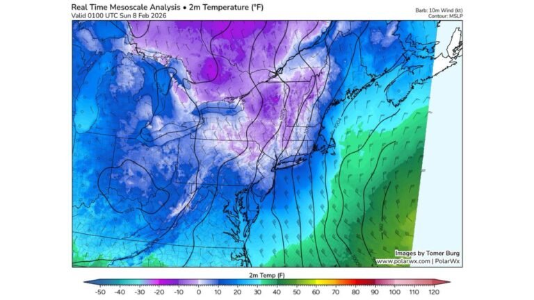
Temperatures Plunge 20+ Degrees Below Average
Once the Arctic air fully settles in, temperatures will fall 20 degrees or more below seasonal averages.
- Saturday highs: generally 20–25°F
- Saturday night lows: teens, with some areas dropping into the single digits
- Sunday morning wind chills: near or below zero, with a few spots feeling closer to -5°F
Even during daylight hours Saturday, wind chills may remain in the single digits, making outdoor conditions harsh and potentially dangerous.
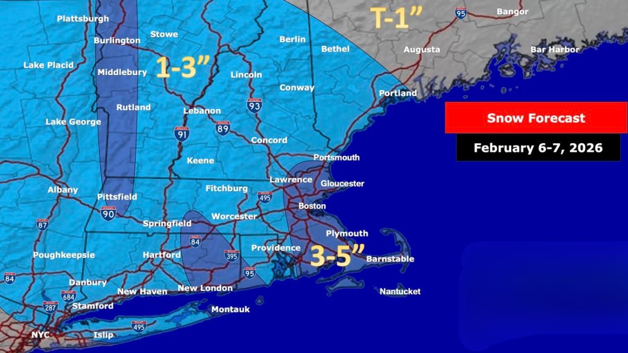
Narrow Snow Bands Could Bring Plowable Snow
High-resolution guidance (including RRFS output) is beginning to hint at a very narrow but potentially intense snow band forming along the leading edge of the cold air.
Where this band sets up is still uncertain, but 3–6 inches of snow is possible within a tight corridor if it locks in.
Current favored zones include:
- Central and northern Vermont
- The Massachusetts coast, including the Boston area
- A wildcard zone tied to a Norlun trough, which could enhance snowfall in a localized strip
Outside these narrow zones, snowfall totals will generally be lighter, ranging from 1–3 inches inland and up to 3–5 inches near parts of the Massachusetts coastline.
What to Expect Heading Into the Weekend
By early Sunday, conditions remain brutally cold, with wind chills near or below zero lingering across much of New England. Travel impacts may ease as snow tapers off, but dangerous cold and lingering gusts will continue to be an issue.
Residents are urged to prepare for rapid weather changes, secure loose outdoor items, and plan for possible power disruptions in wind-prone areas.
If you’re tracking how this Arctic blast and snow threat could affect travel plans, live music events, or weekend schedules, stay tuned to ChicagoMusicGuide.com for continued updates as the forecast sharpens.