Arctic Front Brings Dangerous Cold and Snow Risk Across Pennsylvania, New York, Massachusetts, and New England This Weekend
PENNSYLVANIA — A powerful Arctic front driven by Siberian air is surging into the Northeast this weekend, bringing a dangerous combination of snow, fierce winds, and the coldest air of the season across Pennsylvania, New York, Massachusetts, and much of New England from Friday night through Sunday.
Forecast models show a complex setup with light-to-moderate snowfall, followed by an abrupt plunge into extreme cold as Arctic air overspreads the region. Wind chills are expected to fall well below zero in many areas, prompting Extreme Cold Watches and Warnings across multiple states.
Snowfall Setup Ahead of the Arctic Blast
A weak clipper system is forecast to move through the region late Friday night into Saturday, bringing light snow to a wide portion of the Northeast.
Across Western Pennsylvania, snowfall totals are expected to range between 2 to 4 inches, with similar amounts possible in higher elevations of Eastern Pennsylvania. As the system tracks northeastward into Upstate New York, areas closer to the Great Lakes may see localized enhancement, pushing totals above 4 inches in spots.
In Southern New England, confidence is growing that an inverted trough may develop somewhere between Hartford, Connecticut, and Boston, Massachusetts. While the exact placement remains uncertain, locations that fall beneath this feature could receive 4 to 6 inches of snow, with surrounding areas seeing lighter totals closer to 1 to 3 inches.
Massachusetts, Connecticut, and Coastal New England Snow Totals
Snowfall forecasts indicate sharp gradients across Massachusetts, Rhode Island, and Connecticut. Coastal areas from Boston to Cape Cod could see 3 to 5 inches, while inland sections trend closer to 1 to 2 inches.
Northern New England, including Vermont, New Hampshire, and Maine, may see lighter accumulations overall, generally 1 inch or less, though localized bursts of snow are possible where mesoscale bands develop.
The variability of this setup makes final snowfall totals highly dependent on the precise placement of the inverted trough.
Extreme Arctic Air Follows Behind the Snow
Once the snow exits, the bigger story becomes the arrival of the coldest air of the season.
Temperatures are expected to plunge into the teens by Saturday morning, with daytime highs struggling to reach the low 20s across much of Pennsylvania, New York, and New England. Overnight lows Saturday night are forecast to fall into the single digits, with some interior and higher-elevation locations dipping even lower.
Wind chills will be especially dangerous. East of the Blue Ridge, wind chills of 0 to -10 degrees are expected. West of the Blue Ridge, including parts of Western Pennsylvania and interior New York, wind chills could fall between -10 and -25 degrees, with -30 degrees possible along the Allegheny Front and higher elevations.
Damaging Winds and Power Outage Concerns
Strong pressure gradients behind the Arctic front will produce damaging winds late Friday night into Saturday morning.
Gusts of 40 to 50 mph are likely across large portions of the Mid-Atlantic and Northeast, with 55 mph gusts possible in mountain areas. These winds will exacerbate wind chill values and raise concerns for isolated to scattered power outages, particularly where snow accumulation weighs down trees and power lines.
Wind advisories and high wind warnings are expected to expand as the event draws closer.
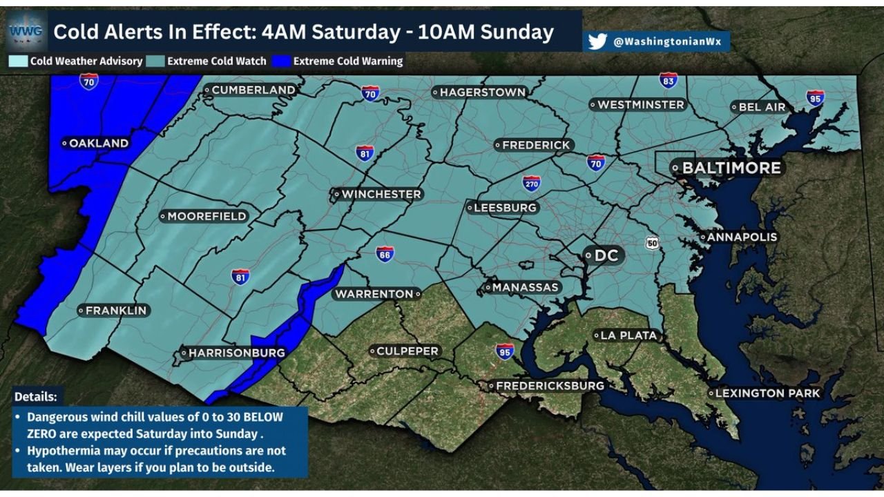
Cold Alerts and Safety Concerns
Extreme Cold Watches and Warnings are in effect from 4 AM Saturday through 10 AM Sunday for much of the region. Wind chills near or below zero are expected to persist for 24 hours or longer in some locations.
Frostbite and hypothermia can occur quickly in these conditions, especially with exposed skin. Officials urge residents to limit time outdoors, dress in multiple layers, and keep pets indoors throughout the weekend.
As winter’s most dangerous air mass yet barrels into the Northeast, residents across Pennsylvania, New York, Massachusetts, and New England should prepare for a weekend defined by snow, bitter cold, and hazardous travel conditions.
For continued weather coverage, winter storm updates, and regional alerts, stay connected with ChicagoMusicGuide.com, your source for major weather developments impacting the U.S. and beyond.