Brutal Arctic Cold and Blowing Snow Target New York, Pennsylvania, Maryland, Virginia, and New England From Friday Night Through Saturday
UNITED STATES — A dangerous winter setup is taking shape across large portions of the Northeast and Mid-Atlantic as a fast-moving clipper system brings snow Friday night, followed immediately by the coldest air of the season and life-threatening wind chills through Saturday.
Forecast data shows this will not be a typical light snow event. Instead, snow, extreme cold, and strong winds will combine into what meteorologists are calling the harshest 24-hour stretch of winter so far, with impacts extending from Pennsylvania and New York into Maryland, Virginia, and Southern New England.
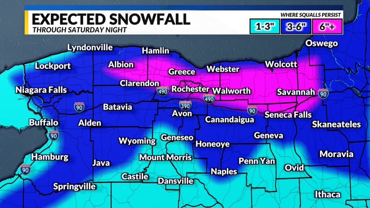
Snowfall Forecast: Where Accumulations Will Be Highest
Snow will begin spreading across the region Friday evening and continue into Saturday, with totals varying sharply by location.
Western Pennsylvania and the higher elevations of Eastern Pennsylvania are expected to see 2 to 4 inches of snow, while areas farther north and east into New York may experience lake-enhanced snowfall pushing totals above 4 inches.
In Southern New England, confidence is growing in the development of an inverted trough somewhere between Hartford, Connecticut, and Boston, Massachusetts. Locations that fall directly under this feature could receive over 4 inches, with isolated spots potentially seeing up to 6 inches of snowfall.
Farther south, including Maryland, Washington D.C., and parts of Northern Virginia, snowfall amounts are lower, generally ranging from a coating to 1 inch, but blowing snow will remain a major concern.
Blizzard-Like Conditions Expected Despite Modest Snow Totals
Forecasters stress that exact snowfall totals will matter far less than the overall setup. Gusty winds will cause snow to blow and drift aggressively Friday night into Saturday, reducing visibility and making travel hazardous even in areas that receive only a few inches.
With snow falling as temperatures rapidly plunge, road conditions are expected to deteriorate quickly, particularly overnight and early Saturday morning.
Extreme Cold Alerts Cover a Large Portion of the Region
Extreme Cold Watches and Warnings are already in effect across much of the Mid-Atlantic and Northeast, with alerts running from 4 AM Saturday through 10 AM Sunday in many areas.
East of the Blue Ridge Mountains, wind chills are expected to fall between 0 and -10 degrees. West of the Blue Ridge — including the Allegheny Front and higher elevations — conditions will be significantly worse, with wind chills ranging from -10 to -25 degrees.
In the mountains of Western Maryland, West Virginia, and parts of Virginia, an Extreme Cold Warning is already active, with wind chill values projected to drop as low as -30 degrees.
Timeline: When the Worst Conditions Will Hit
Friday daytime will be relatively mild by comparison, with scattered snow showers developing late in the day. Conditions rapidly deteriorate Friday evening as an arctic front moves through.
From Friday night into early Saturday, temperatures will plunge while snowfall intensifies briefly. By Saturday morning, the region will be locked into dangerous cold, with scattered lake-effect snow flurries continuing through the day, especially across New York and northern Pennsylvania.
Wind chills near -25 degrees are expected early Saturday, slowly improving by late afternoon but remaining dangerously cold through Saturday night.
Serious Safety Concerns: Frostbite and Hypothermia Risks
Meteorologists are emphasizing that this event must be taken seriously. Frostbite can occur in minutes under these conditions, and hypothermia is a real threat for anyone exposed for extended periods.
Residents are urged to:
- Wear multiple layers instead of a single heavy coat
- Limit time outdoors as much as possible
- Keep pets indoors
- Prepare for dangerous travel conditions due to blowing snow and extreme cold
Even minor exposure during the coldest part of the event could result in injury.
Looking Ahead: Another Winter Storm Possible Next Week
Looking beyond the weekend, confidence is increasing that another storm system could impact the Eastern United States between February 11 and February 14, potentially ending the current dry stretch. However, details on snowfall amounts and exact locations remain uncertain.
Final Word
Whether your location sees 2 inches or 6 inches of snow, the message is the same: this will be a brutal, dangerous winter stretch from Friday night through Saturday, driven by the combined effects of snow, extreme cold, and powerful winds.
Stay weather-aware, take precautions, and avoid unnecessary travel during the worst conditions.
For continuing winter weather updates, storm tracking, and regional impact reports, keep following Chicagomusicguide.com.