HRRR Model Suddenly Paints a Much Bigger Boston Snowstorm, With Some Areas Now Eyeing 12–14 Inches Instead of 4
BOSTON, MASSACHUSETTS — A new high-resolution HRRR weather model update is dramatically reshaping the Boston snow forecast, showing a much heavier snow scenario than earlier projections. What was once shaping up as a 4-inch snowfall for parts of eastern Massachusetts is now trending toward a setup where intense snow bands could deliver 12–14 inches in localized areas if the heaviest corridor locks in.
The latest data highlights a volatile storm structure, where snowfall totals could swing sharply over short distances depending on where the strongest band develops and stalls.
What The HRRR Model Is Showing Over Eastern Massachusetts
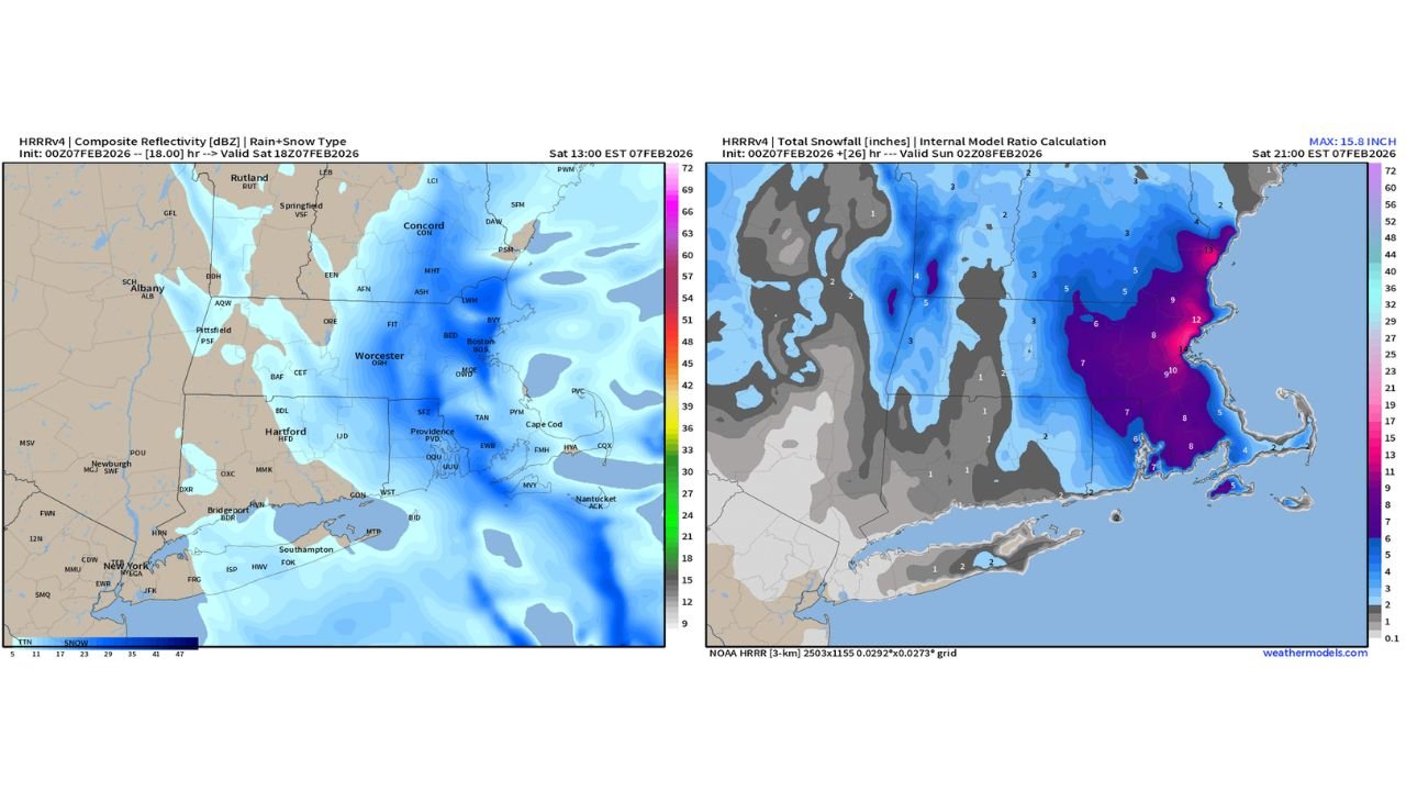
The newest HRRR output depicts a narrow but powerful band of heavy snow setting up across eastern Massachusetts, with the deepest totals focused near the Boston metro area and stretching into coastal sections.
Model snowfall maps show the most aggressive totals concentrated where snowfall rates intensify, a hallmark of band-driven winter storms. In these scenarios, snow can fall heavily for several consecutive hours, quickly piling up totals far beyond early expectations.
The data also shows tight gradients, meaning communities only a few miles apart could see dramatically different outcomes by the time the storm ends.
Why Boston Could Wake Up to Heavy Snow Instead of a Light Event
One of the biggest red flags in the HRRR update is the timing and placement of the heaviest snow. The model suggests that the most intense snowfall could occur overnight into early morning, increasing the risk that residents wake up to conditions far worse than anticipated.
This is how a forecast jumps from “manageable” to “major” quickly. If the snow band strengthens and remains anchored over the same area, accumulation accelerates rapidly — especially in urban corridors like Boston, where snowfall rates can overwhelm road treatment efforts.
This setup explains why totals as high as 12–14 inches are even on the table while surrounding areas remain much lower.
Snowfall Ranges By Location Based on Current Data
Based strictly on the HRRR snowfall depiction and band placement:
- Boston and immediate eastern Massachusetts: 10–14 inches, with the highest totals where the snow band persists longest
- Worcester and interior eastern Massachusetts: 6–8 inches, with potential for higher amounts if the band shifts inland
- Providence, Rhode Island: 4–6 inches, highly sensitive to the northern edge of the heavy snow zone
- Cape Cod and coastal Massachusetts: 8–12 inches, aided by coastal enhancement and lingering snowfall
These numbers are not guarantees — they reflect how sharply totals can increase if the band locks in over a specific area.
Travel Impacts and Rapid Visibility Drops During Peak Snow
Regardless of final totals, this setup raises serious travel concerns due to how fast conditions can deteriorate. In a banded storm, roads can go from wet to snow-covered in minutes, and visibility can collapse during the heaviest bursts.
Drivers across Boston, eastern Massachusetts, and nearby parts of Rhode Island should be prepared for sudden slowdowns, especially during overnight and early morning hours when plows may struggle to keep up with snowfall rates.
Bridges, untreated side streets, and coastal roadways are especially vulnerable once temperatures drop and compacted snow turns icy.
What This Means for Boston Nightlife, Venue Travel, and Weekend Plans
For anyone heading out in Boston or traveling across eastern Massachusetts this weekend, the key issue is uncertainty combined with intensity. Snow arriving overnight, followed by the potential for prolonged heavy bursts, could complicate travel to concerts, venues, and late-night events.
If the higher-end scenario verifies, getting home may be more difficult than getting out, as falling temperatures and continued snowfall reduce traction and visibility. Coastal areas and neighborhoods closer to the heaviest band may experience the worst conditions.
Planning ahead, allowing extra travel time, and avoiding unnecessary late-night driving could make the difference if the storm ramps up quickly.
As the HRRR model continues to refine where the heaviest snow band sets up, Boston’s snowfall outcome remains highly sensitive — with the difference between 4 inches and over a foot hinging on just a small shift in storm structure. For more Weather updates tied to concerts, nightlife, and weekend planning, visit ChicagoMusicGuide.com.