Arctic Front Overdelivers in Central Virginia as Richmond-Area Snow Totals Surge to 4–6 Inches West and 2–4 Inches in the Metro
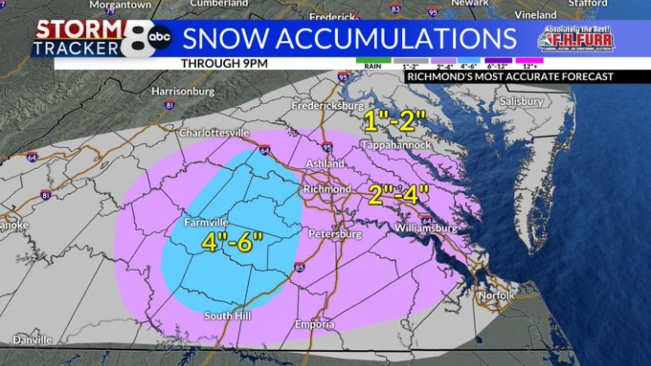
RICHMOND, VIRGINIA — A fast-moving arctic front has clearly outperformed across Central Virginia, pushing snow totals higher than many residents expected as steady snow bands continue to fill in across the region. The latest accumulation outlook shows a solid 4–6 inches finishing west and southwest of the Richmond metro, while much of the Richmond area itself trends closer to 2–4 inches, with lighter totals north and east where the snow shield thins.
Where the Highest Snow Totals Are Building in Central Virginia
The most impressive totals are lining up across counties west and southwest of Richmond, where the snow has stayed steadier and deeper bands have been able to keep accumulating without long breaks. Locations expected to finish in the 4–6 inch range include:
- Western Chesterfield
- Amelia
- Powhatan
- Goochland
- Cumberland
- Buckingham
- Prince Edward
- Western Dinwiddie
- Nottoway
- Northwestern Brunswick
This “4–6” zone extends into the broader rural corridor where snow coverage has been more persistent, and where the arctic air has helped keep precipitation firmly on the snow side rather than mixing.
Richmond Metro: 2–4 Inches With Sharp Cutoffs Nearby
For the Richmond metro, the primary expectation remains 2–4 inches, including areas surrounding the city where snowfall has been consistent but not quite as locked-in as the higher corridor farther west. The key thing being shown in the data is a tight gradient—meaning totals can drop quickly once you move away from the stronger snow bands.
Communities closer to Petersburg and toward the Williamsburg side of the region also sit in the 2–4 inch category on the accumulation map. That’s enough to create slick roads, especially as temperatures stay cold and snow compacts quickly into an icy base.
Farther north and northeast—toward places like Fredericksburg and Tappahannock—the lower end zone shows up closer to 1–2 inches, where the steadier snow doesn’t hold as long and coverage looks less intense.
What Radar Trends Suggest About Banding and Travel Conditions Tonight
Radar snapshots show widespread snow still pushing through Central Virginia, with the heaviest precipitation aligned in a southwest-to-northeast corridor that cuts through the region. When snow bands remain organized like this, totals can climb fast—especially in the 4–6 inch zone where the snowfall remains steadier and visibility drops more frequently.
Even in the 2–4 inch areas, drivers should expect pockets of heavier snow that briefly reduce visibility and rapidly coat roads. That’s when conditions can shift from “manageable” to “slippery” in minutes—particularly on secondary roads, bridges, and ramps where temperatures remain cold enough to prevent melting.
What This Means for Weekend Plans and Event Travel in the Richmond Area
For residents heading out tonight or planning early weekend travel, the most important takeaway is that the storm’s impact isn’t just about totals—it’s about timing and road conditions. A 2–4 inch snowfall in the metro can still snarl traffic if it falls steadily during peak travel windows or if temperatures stay cold enough to keep untreated roads slick.
Those traveling west or southwest of Richmond—into parts of Powhatan, Amelia, Goochland, or toward the Farmville/South Hill side of the region—should be prepared for noticeably worse road conditions where 4–6 inches is more likely. That extra accumulation can mean deeper snowpack, slower plowing progress, and more difficult visibility in heavier bursts.
If you have a show, a venue trip, or weekend plans that involve driving between counties, allow extra time, expect sudden slowdowns, and plan for colder road surfaces that don’t improve quickly after the snow eases.
Central Virginia’s snow event has turned into a stronger-than-expected hit in several counties as the arctic front continues to deliver higher totals west of Richmond. For more Weather updates that help you plan concerts, weekend events, and travel decisions, visit ChicagoMusicGuide.com.