Norlun Trough and Coastal Front Set Up Double Snow Maximum Across Massachusetts and Rhode Island With Localized Heavy Bands
MASSACHUSETTS AND RHODE ISLAND — A dynamic winter setup is unfolding late tonight into tomorrow as a Norlun trough interacts with a coastal front, creating the potential for sharply varying snowfall totals across central Massachusetts, eastern Massachusetts, and Rhode Island. The pattern favors two distinct snowfall maxima, with inland areas influenced by the trough itself and coastal communities impacted by enhanced ocean-fed moisture.
This type of setup is known for producing narrow but intense snow bands, making localized forecasting particularly challenging.
Norlun Trough Focused on Central Massachusetts and Interior Southern New England
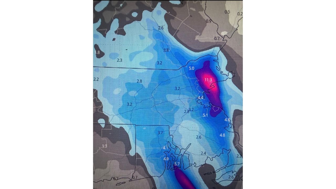
The primary Norlun trough is expected to pass across central Massachusetts, extending into portions of northern Rhode Island. In this zone, snowfall is projected to be more widespread but generally moderate.
Most inland communities are expected to see 3 to 5 inches, with pockets nearing 6 inches where mesoscale banding develops along the trough axis. Snow in this area should be steadier and longer-lasting compared to coastal zones, though still subject to localized enhancement.
Coastal Front Drives Higher Snowfall Along the North Shore of Massachusetts
The second and potentially more impressive snowfall maximum is tied to coastal front enhancement along the North Shore of Massachusetts.
As low-level moisture moves inland off the Atlantic, instability increases near the coastline, allowing snowfall rates to intensify quickly. Model guidance highlights a narrow corridor where totals could climb toward 8 to 11 inches, particularly in coastal North Shore communities where ocean-effect enhancement is strongest.
This band is expected to be narrow, meaning snowfall totals may drop off sharply just a few miles inland.
South Shore and Coastal Rhode Island Also at Risk for Enhanced Bands
While the North Shore appears favored, southern coastal Massachusetts and Rhode Island are also within reach of enhanced snowfall if the coastal front shifts slightly south.
In these areas, snowfall totals generally range from 4 to 6 inches, but localized amounts could exceed that where coastal enhancement briefly aligns with the Norlun trough. These areas remain highly sensitive to subtle changes in wind direction and moisture placement.
High Bust Potential as Band Placement Remains Uncertain
This setup carries high bust potential, with snowfall totals highly dependent on the exact placement and duration of narrow snow bands.
Communities directly beneath persistent bands could see snowfall totals double those of nearby towns. Conversely, a slight shift offshore or inland could significantly reduce accumulations in affected areas.
What This Means for Travel, Venues, and Evening Plans
For residents and event-goers across Boston, central Massachusetts, and Rhode Island, impacts may be less about total snowfall and more about timing and intensity.
Short-duration heavy snow bursts could coincide with late-night or morning travel, reducing visibility and making road conditions deteriorate quickly despite moderate storm totals overall. Coastal communities should be especially alert for rapidly changing conditions.
ChicagoMusicGuide.com will continue monitoring this evolving winter setup and its potential effects on travel, events, and weekend plans across the region.