Pennsylvania, New Jersey, New York, Connecticut, and Massachusetts Along I-95 See Coldest Air of the Winter as Narrow Arctic Airmass Locks In
UNITED STATES — A narrowly focused but unusually intense Arctic airmass is sliding through the Northeast, producing one of the coldest localized temperature corridors of the winter along the I-95 stretch from Philadelphia through New York City and into southern Connecticut. Mesoscale temperature analysis shows this cold ribbon standing out sharply against surrounding regions, a setup that forecasters say is uncommon outside of specific winter patterns.
Rather than a broad blanket of cold air, this system is defined by its tight width, sharp gradients, and precise placement, making its impacts especially noticeable for major metro areas packed closely along the interstate corridor.
Why the I-95 Corridor Is the Coldest Spot Right Now
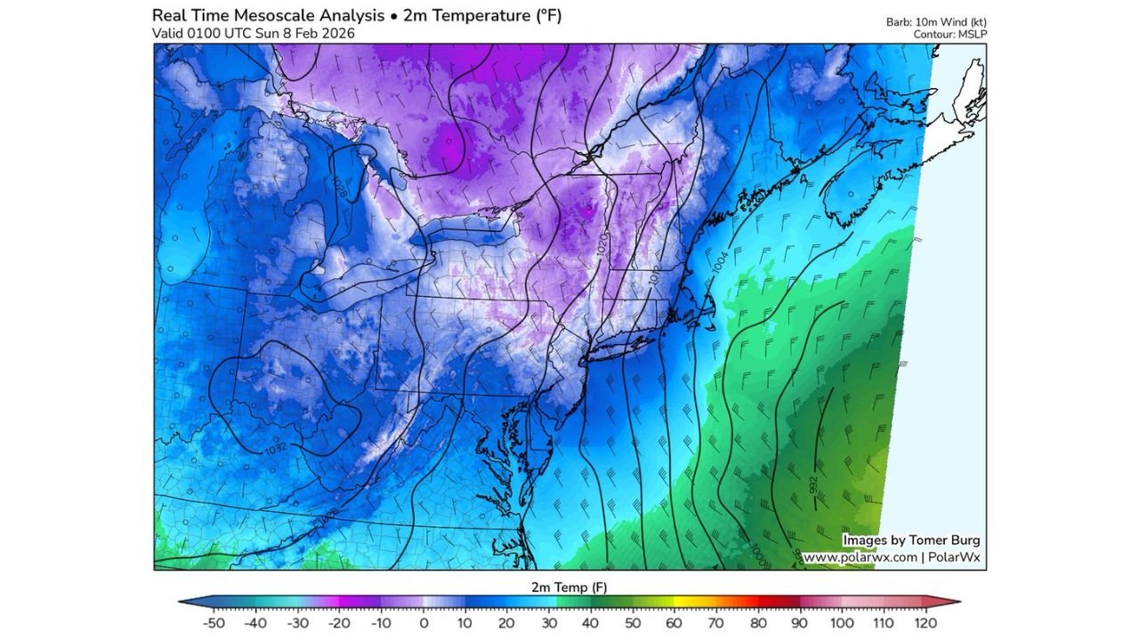
The temperature maps reveal a distinct purple-to-deep-blue band running from eastern Pennsylvania through northern New Jersey, New York City, and into New Haven, Connecticut. This indicates temperatures several degrees colder than areas just 30–50 miles away.
Meteorologically, this happens because the angle of approach of the Arctic air is nearly parallel to the coastline. Instead of flooding the entire region evenly, the cold air becomes funneled and trapped, maximizing its impact along a very specific zone.
This type of setup is rare and typically only appears during:
- Backdoor cold front events
- Narrow Arctic intrusions
- Localized winter precipitation systems that reinforce surface cooling
State-by-State Breakdown of the Coldest Impacts
Pennsylvania:
Eastern Pennsylvania, especially the Philadelphia metro, is sitting near the western edge of the cold core. Temperatures here are notably colder than central and western parts of the state, despite similar elevations.
New Jersey:
Northern and central New Jersey are directly under the cold ribbon. Inland areas are colder than both the Delaware Valley and the immediate coastline, highlighting how localized the setup is.
New York:
New York City stands out as one of the coldest points along the entire I-95 route — an unusual distinction given the city’s typical urban heat advantage. The cold air is dense enough to overwhelm that effect.
Connecticut:
Southern Connecticut, including New Haven and nearby coastal communities, is locked into the coldest air. Northern Connecticut, meanwhile, is slightly warmer, underscoring the narrowness of the airmass.
Massachusetts:
While eastern Massachusetts is cold, Boston itself sits just east of the core. The most intense cold is focused farther southwest, keeping Massachusetts colder than normal but not the coldest in the region.
Why This Pattern Is Unusual for Mid-Winter
In most winter cold outbreaks, temperatures decrease gradually from north to south. This event flips that expectation by placing the coldest air in a narrow, urbanized strip, while surrounding areas remain less extreme.
The maps suggest:
- Strong surface pressure gradients
- Limited mixing due to stable low-level air
- Offshore flow preventing moderation from the Atlantic
Because of this, the cold becomes locked in place, rather than quickly eroding.
What This Means for Travel, Infrastructure, and Daily Life
For residents and travelers along I-95:
- Morning wind chills feel significantly colder than forecast averages
- Black ice risk increases due to sharp temperature contrasts
- Commuters experience colder conditions than nearby suburbs
Airports serving Philadelphia, Newark, JFK, LaGuardia, and New Haven also sit squarely within this cold zone, increasing the risk of weather-related delays even without major snowfall.
The Bottom Line
This is a textbook example of a narrow Arctic intrusion, where geography, wind direction, and timing combine to produce a colder corridor than anywhere else along the East Coast. While not record-breaking, its precision and placement make it one of the more meteorologically interesting cold events of the season.
Cold like this doesn’t happen often — but when it does, the I-95 corridor feels it first and hardest.
Want more deep-dive weather breakdowns like this? Stay locked to ChicagoMusicGuide.com for regional analysis that goes beyond the basic forecast and explains why the weather behaves the way it does.