Feb 14–15 East Coast Winter Storm Hype Faces Pushback Across New York, Pennsylvania, New England, and the Mid-Atlantic
UNITED STATES — As talk ramps up online about a potential February 14–15 East Coast winter storm, a growing number of meteorologists are urging caution, saying the current hype is being driven by single-run AI weather models without meaningful ensemble or pattern support.
While several AI-based European and GFS model runs have shown dramatic storm solutions for parts of the Northeast, Mid-Atlantic, and New England, forecasters stress that these projections are not supported by the broader atmospheric setup expected later this month.
Why Meteorologists Are Pushing Back on the Storm Narrative
Weather experts emphasize that AI versions of the GFS and ECMWF models are still deterministic, meaning they behave just like a single operational model run — not a consensus forecast.
Despite faster output and sharper graphics, these AI solutions:
- Do not gain reliability simply because they run quicker
- Still require ensemble agreement to be trusted
- Can easily produce outlier solutions at long range
Forecasters note that several widely shared AI storm scenarios currently lack support from their own ensemble members, raising red flags about credibility.
Ensemble Data Does Not Support a Major East Coast Storm
Ensemble guidance — which blends dozens of model simulations — is showing low confidence in a significant Feb 14–15 winter storm:
- Many ensemble members show no storm at all
- Others keep systems too weak or offshore
- Some solutions directly contradict the AI operational runs
When a deterministic solution runs against its own ensemble mean, meteorologists typically treat it as noise rather than signal.
Large-Scale Pattern Works Against a Big Storm Setup
Beyond individual models, the hemispheric pattern also argues against a major East Coast snowstorm.
Key factors include:
- Madden–Julian Oscillation (MJO) expected to move into Phase 3 by mid-February
- Phase 3 historically suppresses East Coast storm amplification
- Upper-air pattern favors troughing in the Pacific, not the Eastern U.S.
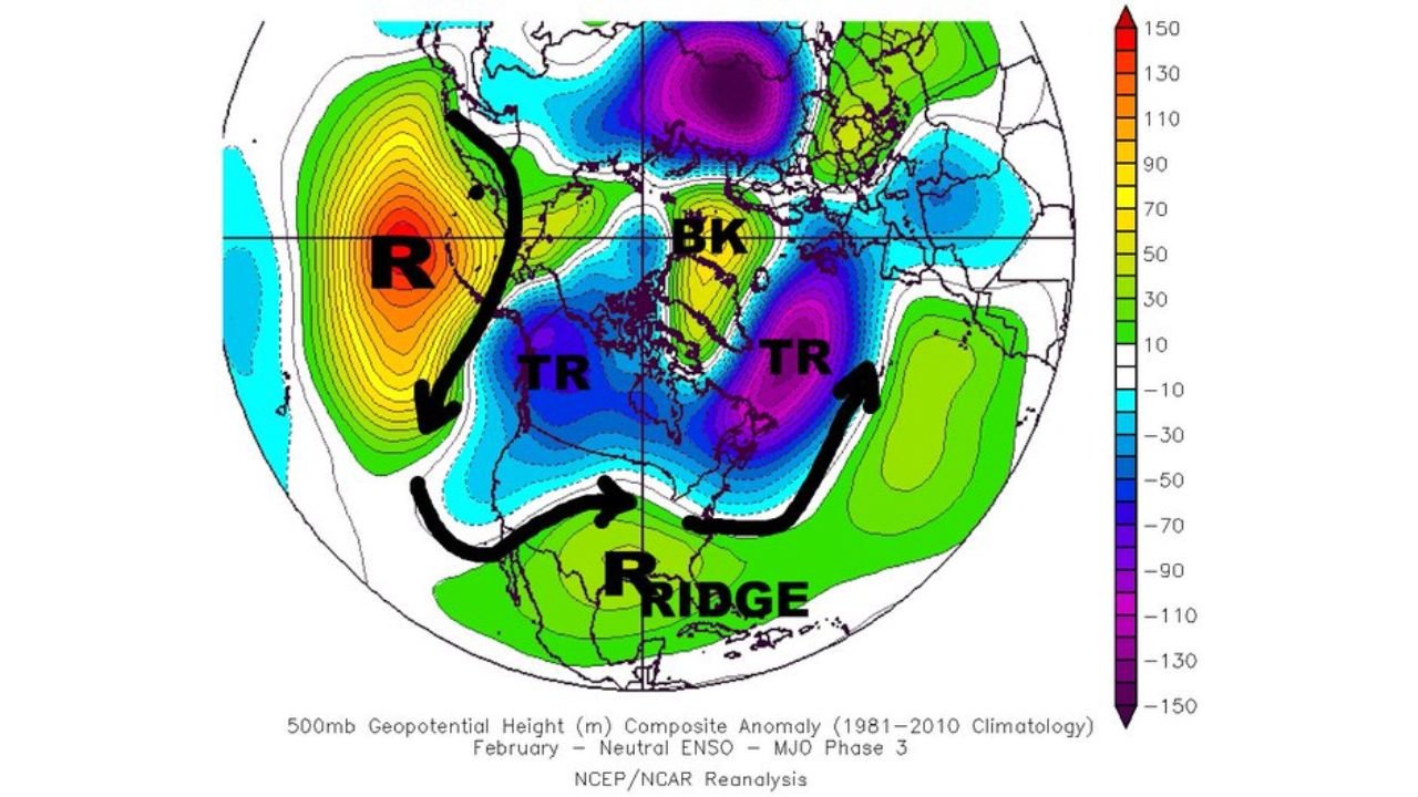
Composite maps tied to MJO Phase 3 consistently show reduced East Coast winter storm potential, making current hype even harder to justify.
Why AI Weather Models Are Being Misinterpreted
Meteorologists say part of the problem lies in how AI weather output is shared online.
AI models:
- Produce eye-catching graphics
- Are often posted without ensemble context
- Give a false sense of certainty at long range
Experts warn that faster output does not equal better forecasting, especially beyond 7–10 days.
What Forecasters Are Actually Watching Instead
Rather than locking onto one storm date, weather desks are monitoring:
- Evolution of the Pacific jet stream
- Whether troughing shifts eastward later in February
- Ensemble trends — not individual runs
- Pattern alignment with AO/NAO changes
Until those signals align, confidence remains low for any Feb 14–15 storm scenario.
Bottom Line for the East Coast
For now, meteorologists advise the public to temper expectations.
- No strong ensemble support
- Pattern works against a major storm
- AI solutions remain outliers
While winter is far from over, experts say there is currently no solid evidence to support widespread claims of a significant East Coast winter storm during the February 14–15 timeframe.
Stay with Chicagomusicguide.com for clear, data-driven weather analysis — not hype.