Colder, Snowier Pattern Takes Shape Across the Western U.S., Setting Up a Strong Second Half of Ski Season
UNITED STATES — A major pattern change is nearing across the Western United States, with forecast data signaling a colder and significantly snowier setup over the next two weeks. The shift arrives at a critical time for mountain regions, offering what could be an ideal restart to the second half of the ski season from the Pacific Northwest and California through the Rockies and Intermountain West.
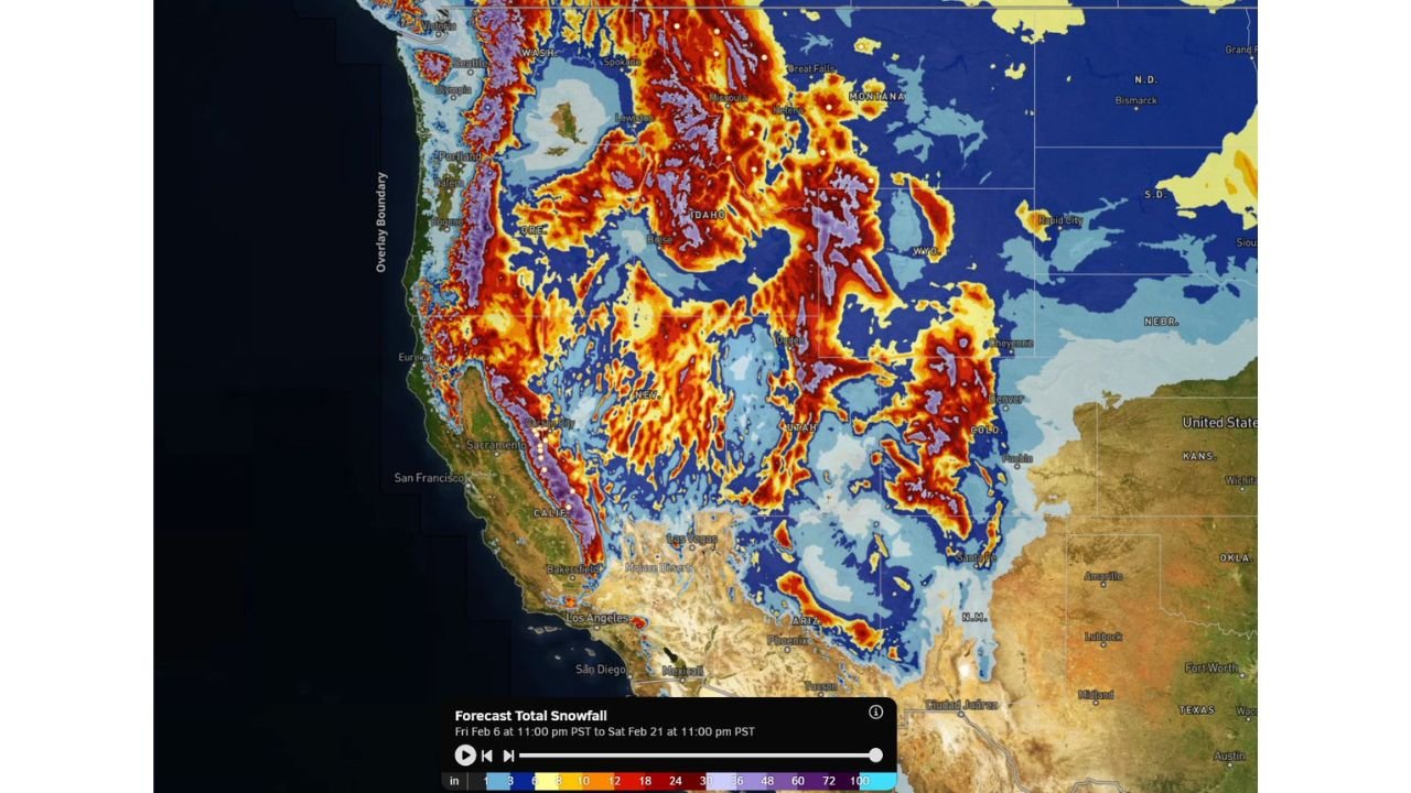
Snowfall projections show repeated rounds of moisture interacting with colder air, favoring widespread mountain accumulations and sustained snowpack growth as February progresses.
Large-Scale Pattern Shift Brings Sustained Cold and Storminess
Forecast guidance highlights a transition away from recent milder conditions toward a more amplified western trough, allowing colder air to settle across much of the region. This pattern supports frequent storm systems, rather than a single short-lived event.
The setup favors multiple snow-producing waves, increasing confidence that snowfall will accumulate steadily over time, particularly in higher elevations.
Heaviest Snow Focused on Key Mountain Ranges
Snowfall maps show robust totals across major western mountain zones, including:
- Pacific Northwest Cascades, from Washington into Oregon
- Northern and Central Rockies, including Montana, Idaho, Wyoming, and Colorado
- Sierra Nevada, where colder air increases snow efficiency
- Wasatch Range and Utah mountains, benefiting from storm-enhanced snowfall
Many higher elevations are projected to receive multiple feet of snow over the two-week period, with locally higher totals in favored terrain.
California and the Sierra See a Much-Needed Boost
California’s mountains stand out in the forecast, with widespread snowfall extending from northern California through the central and southern Sierra Nevada. This colder pattern supports snow reaching lower resort elevations, improving base depth and surface quality.
Repeated storms also reduce the risk of prolonged melt, helping preserve snowpack deeper into late winter.
Rockies and Intermountain West Lock Into Winter Mode
Across Idaho, Montana, Utah, Colorado, and Wyoming, the colder pattern allows snow to fall more consistently with fewer rain intrusions. Resorts in these regions are well-positioned for high-quality powder cycles, particularly during periods of enhanced lift and colder overnight temperatures.
Valley locations may see lighter accumulations, but mountain travel impacts are likely during stronger storm passages.
Why This Pattern Is Ideal for the Ski Season
Unlike short-lived cold snaps, this setup favors longevity. The combination of colder air and repeated moisture increases the odds of:
- Sustained snowpack growth
- Improved trail coverage at lower elevations
- Better snow quality with less freeze-thaw
- Reduced reliance on artificial snowmaking
For ski areas, this type of pattern often defines the best stretch of the season.
What to Watch Going Forward
While confidence is high in a colder and snowier trend, exact snowfall totals will depend on storm timing and track. Forecasters will be monitoring:
- Storm frequency and spacing
- Snow levels during stronger systems
- Wind impacts at higher elevations
- Travel conditions through mountain passes
Refinements over the coming days will determine which regions see the most significant totals, but the overall signal remains favorable.
As winter reasserts itself across the West, the next two weeks may deliver some of the most impactful mountain snowfall of the season. For continued snow forecasts, winter weather trends, and ski-season updates, visit ChicagoMusicGuide.com.