Record-Breaking Snow Totals Pile Up Across New York, Vermont and Maine as Winter Delivers Relentless Season-to-Date Accumulations
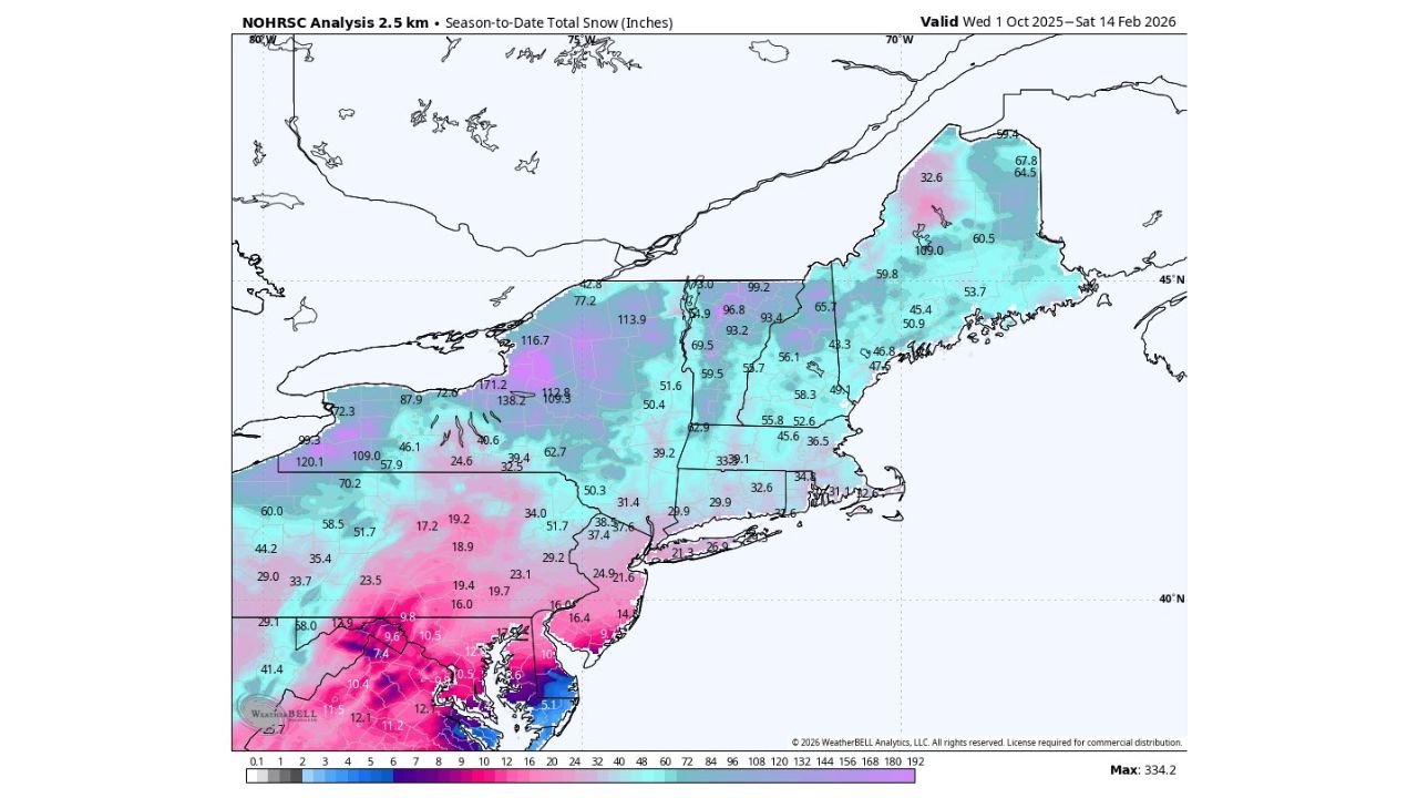
ALBANY, NEW YORK — It has been an exceptional winter across much of the Northeast, with season-to-date snowfall totals climbing well above average in parts of New York, Vermont, New Hampshire, and Maine. According to the latest seasonal snow analysis valid through February 14, several areas have already surpassed 100 inches, and winter is not finished yet.
Cold temperatures have played a major role, preventing frequent melt cycles and allowing snowpack to steadily build over the past several months.
Upstate New York Leads With Over 170 Inches in Spots
Some of the most impressive totals are centered across western and central New York, particularly in lake-effect-prone regions.
Highlighted snowfall amounts include:
- 171.2 inches in parts of western New York
- 138.2 inches in nearby areas
- 120.1 inches across additional lake-effect zones
Lake Ontario and Lake Erie have once again contributed significantly, funneling repeated snow bands into communities that have experienced sustained accumulation since early winter.
Even outside traditional lake-effect belts, many areas of upstate New York are reporting totals above 90 inches, signaling a strong and consistent snow season.
Northern New England Continues to Stack Snow
The snow story does not stop in New York. Northern New England has also recorded substantial totals:
- 113.9 inches in portions of Vermont
- Widespread 90 to 100 inch totals across northern New Hampshire
- 60 to 70 inches common across much of Maine
Higher elevations in Vermont and New Hampshire have consistently added to their snowpack thanks to colder-than-average air masses persisting across the region.
Communities from Burlington to Bangor have seen steady snowfall events rather than isolated blockbuster storms, resulting in a deep and durable winter landscape.
Southern New England and Mid-Atlantic Also See Healthy Totals
While not as extreme as upstate New York, parts of Massachusetts, Connecticut, and Rhode Island have accumulated between 30 and 60 inches so far this season.
Even areas closer to the New Jersey and Pennsylvania border regions show meaningful totals in the 20 to 40 inch range, particularly in elevated terrain.
The key theme this winter has been persistent cold. With fewer extended warm-ups, snow has remained on the ground longer, helping build snow depth across the Northeast.
Cold Air Has Been the Difference
Meteorologists note that what has made this winter stand out is not necessarily a single record-breaking storm, but rather:
- Repeated moderate snow events
- Sustained below-normal temperatures
- Limited melting between systems
This combination has allowed totals to steadily climb rather than fluctuate.
With more than a month of winter still remaining, forecasters caution that additional snowfall could push some regions toward even more impressive seasonal benchmarks.
What Comes Next?
Climatologically, February and early March can still deliver significant snow events across New York and New England. If cold air continues to dominate, totals could climb higher before the season transitions into spring.
For now, residents across Albany, Syracuse, Buffalo, Burlington, Concord, and Portland are experiencing one of the more memorable snow seasons in recent years.
As winter continues across the Northeast, snowfall totals remain on track to grow even further. For continued updates on regional snow patterns, seasonal trends, and winter outlooks across the United States, visit ChicagoMusicGuide.com.