Ohio Valley to Deep South Braces for Three-Day Severe Storm Stretch as Wednesday Through Friday Show Escalating Supercell Signals
LOUISVILLE, KENTUCKY — With the weekend severe threat now behind us, attention is quickly turning to a potentially active stretch of weather across the Ohio Valley and Deep South. Forecast guidance indicates that Wednesday, Thursday, and Friday could each feature a risk of severe storms, with Friday appearing to carry the strongest signal at this stage.
Model-derived Supercell Composite Parameter (SCP) guidance shows multiple days with favorable environments developing from the Midwest into the Lower Mississippi Valley, suggesting that organized thunderstorms may become a repeated concern through the end of the workweek.
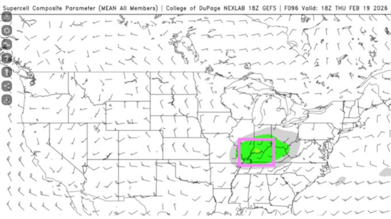
Wednesday: Initial Signal Over the Ohio Valley
The first area of concern centers on Wednesday, when elevated supercell parameters appear across portions of:
- Kentucky
- Indiana
- Southern Ohio
- Western West Virginia
While the overall signal is modest, guidance indicates sufficient wind shear and instability could overlap across the lower Ohio Valley. This setup may support isolated strong to severe storms if moisture return is adequate.
Cities such as Louisville, Lexington, Cincinnati, and Indianapolis sit within the highlighted zone where atmospheric conditions may briefly align.
At this point, instability appears somewhat limited, but shear profiles could compensate if storms can develop.
Thursday: Risk Expands South and West
By Thursday, the area of concern shifts and broadens, extending into:
- Western Kentucky
- Tennessee
- Arkansas
- Northern Mississippi
Supercell composite guidance strengthens slightly, indicating a more favorable overlap of instability and shear. This could lead to a greater chance of organized thunderstorms compared to Wednesday.
If Gulf moisture advances northward, damaging winds and isolated tornadoes could enter the conversation. Timing and moisture depth will remain key variables.
Friday: Deep South Signal Strengthens
The most notable signal appears on Friday, when supercell composite parameters expand across parts of the Deep South, including:
- Louisiana
- Mississippi
- Alabama
- Possibly portions of the Florida Panhandle
The forecast maps show a broader and more concentrated zone of favorable storm ingredients. Wind shear remains strong, and instability may increase further south where richer moisture resides.
Forecasters note that if trends continue, Friday could present the most organized severe threat of the week. All hazards — including damaging winds, hail, and tornadoes — would need to be monitored closely.
Why This Multi-Day Pattern Matters
Multi-day severe setups increase the complexity of forecasting. Each day features slightly different ingredients and geographic focus, but the overall pattern suggests:
- Persistent upper-level support
- Repeated moisture transport from the Gulf
- Strong wind shear across the Midwest and South
The key unknown remains how much instability materializes each day. If moisture underperforms, threats may stay isolated. If it overperforms, the environment could support more robust storm development.
Residents from the Ohio Valley through the Lower Mississippi Valley should monitor daily updates, as subtle forecast shifts could elevate localized risk levels.
As the week unfolds, meteorologists will refine timing and hazard details for each day. For continued updates on severe weather trends and developing storm threats across the United States, visit ChicagoMusicGuide.com.