Midwest to Northeast Braces for Potential Multi-System Snow Stretch as New AIFS Outlook Signals 6–12 Inches in Parts of Michigan, New York and New England
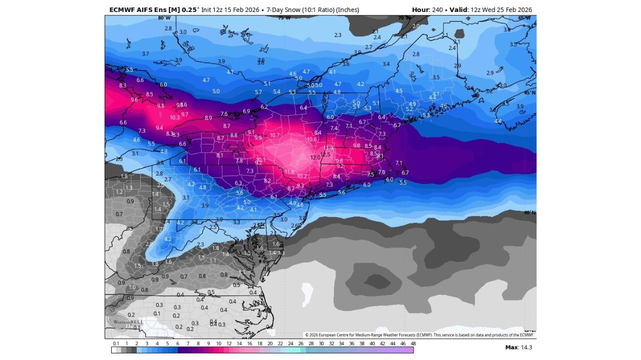
DETROIT, MICHIGAN — A new 7-day ensemble snowfall outlook is raising attention across the Midwest and Northeast, signaling the potential for multiple winter systems from next Wednesday through the following Wednesday. The latest AIFS ensemble mean guidance suggests a corridor of accumulating snow stretching from Michigan and northern Indiana through Ohio, Pennsylvania, New York, and into New England.
Forecasters emphasize this map does not represent exact snowfall totals for individual neighborhoods. Instead, it highlights a broader signal that winter weather may remain active into late February.
Snow Corridor Extends From Great Lakes to New England
The ensemble mean projection shows a swath of higher snowfall potential centered across:
- Southern Michigan
- Northern Indiana
- Northern Ohio
- Western and Central Pennsylvania
- Upstate New York
- Interior New England
Within this corridor, modeled 7-day averages show pockets of 6 to 12 inches, with some localized areas hinting at even higher potential depending on storm tracks.
Cities including Detroit, Cleveland, Buffalo, Albany, Syracuse, and parts of Boston’s interior suburbs sit within or near this highlighted zone.
The strongest signal currently appears across portions of Michigan into upstate New York, where ensemble clustering suggests repeated opportunities for accumulating snow.
Important: This Is a Pattern Signal, Not a Backyard Forecast
Meteorologists caution that ensemble mean snowfall maps are often misunderstood. These projections are designed to show where the overall pattern may support wintry weather, not precise totals for specific towns.
Key points to remember:
- The map does not include tonight’s snow event
- It represents a 7-day average across multiple model runs
- Higher shading can sometimes reflect greater model disagreement, not guaranteed heavy snow
Where snowfall appears maximized on the map may actually indicate the largest margin for track uncertainty, rather than the most certain heavy snow zone.
Forecasters stress that individual storm details — including rain/snow lines and localized banding — cannot be determined at this range.
Multiple Systems Possible, Including Early-Week Clipper
Long-range guidance suggests the pattern could support multiple systems, potentially including:
- A clipper-type system early in the period
- One or two larger-scale systems later in the week
- Periods of reinforcing cold air across the Great Lakes and Northeast
If these systems track favorably, snow events could range from moderate accumulations to more significant snowstorms. However, each event will depend heavily on precise storm paths and temperature profiles.
Winter Is Not Finished Yet
Despite recent stretches of winter weather, forecasters note that February and early March remain climatologically active for snow across the Midwest and Northeast.
With sustained cold air in place and multiple disturbances possible, the coming week could reinforce the idea that winter still has more to offer.
Communities across Detroit, Chicago’s northern suburbs, Cleveland, Pittsburgh, Buffalo, Albany, and interior New England should monitor forecast updates closely as individual systems come into clearer focus.
The broader takeaway is simple: the pattern favors wintry weather returning in waves rather than a single isolated event.
As meteorologists refine storm tracks and timing in the days ahead, more clarity will emerge on which cities see the heaviest snow. For continued updates on developing winter systems and regional weather trends across the United States, visit ChicagoMusicGuide.com.