Pacific Northwest Faces Rare Lowland Snow Chance as Deep Offshore Trough Drives Cooler Pattern Into Washington and Oregon
SEATTLE, WASHINGTON — A cooler weather pattern is pushing into the Pacific Northwest as a deep offshore trough settles just west of Washington and Oregon by Monday, bringing widespread showers, falling temperatures, and even a non-zero chance of isolated lowland snow across parts of the region.
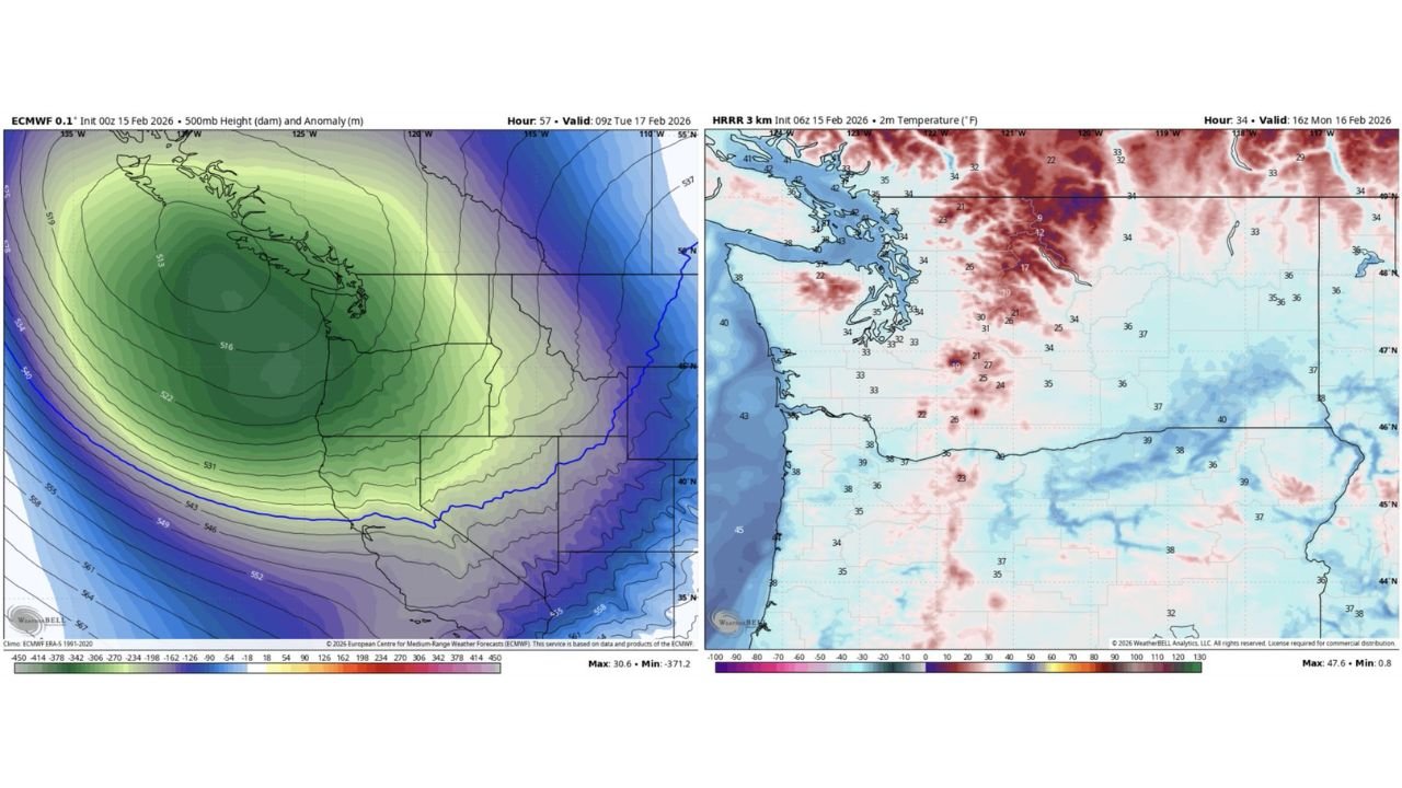
Forecast model data highlights a pronounced 500mb trough positioned just offshore, signaling a shift away from recent milder conditions toward a colder, more unsettled pattern. This upper-level setup is expected to dominate through early next week, supporting below-normal temperatures and periodic precipitation across Western Washington, Western Oregon, and into parts of Southwest British Columbia.
Deep Offshore Trough Brings Cooler Air Into Washington and Oregon
Ensemble guidance shows a well-defined dip in upper-level heights along the Pacific Northwest coastline. The deep trough offshore enhances onshore flow, allowing cooler marine air and instability to spread inland. The placement of this system just west of Vancouver Island, extending south toward Oregon, is key to keeping temperatures suppressed.
Surface temperature guidance shows readings in the 30s to low 40s across much of Western Washington, including Seattle, Tacoma, and Olympia, with colder pockets over higher terrain. Overnight lows dipping into the low-to-mid 30s raise the potential for mixed precipitation in some lower-elevation areas if heavier showers develop.
While this is not a major winter storm setup, the colder air mass aloft combined with showers means snow levels could briefly drop close to sea level in isolated spots — particularly during heavier bursts of precipitation.
Isolated Lowland Snow Not Guaranteed, But Possible
Forecasters stress that this is not a high-confidence snow event for major metro areas. However, there is a non-zero chance of isolated lowland snow, especially during overnight or early morning hours when temperatures are at their coldest.
Model-derived 2-meter temperature data suggests many lowland areas hover just above freezing, meaning any snow that falls would likely be wet and short-lived. Accumulation, if any, would be limited and highly localized.
Higher elevations in the Cascades, Olympic Mountains, and foothills stand a better chance of measurable snowfall as colder air filters into the region. Mountain passes could see fresh accumulations depending on shower intensity and timing.
Showery Pattern Extends Through Early Week
Beyond the snow question, the broader story is a transition to a cooler and wetter regime. The offshore trough promotes periodic shower bands rotating inland, bringing scattered rain across Puget Sound, Portland, and surrounding communities.
This pattern does not appear especially organized or severe, but it will keep conditions unsettled. Cloud cover and onshore flow will prevent significant daytime warming, maintaining a chilly feel across the region.
By Tuesday, ensemble mean data suggests the trough slowly shifts eastward, but cool air remains entrenched over much of the Pacific Northwest. That keeps the door open for continued shower activity and marginal snow levels, especially during nighttime hours.
Winter Not Done Yet in the Northwest
Although mid-February typically begins the gradual transition toward spring, this setup reinforces that winter is not quite finished for the Pacific Northwest. Even brief, isolated lowland snow events can create travel disruptions or localized slick spots if showers align with peak cooling periods.
At this stage, the forecast emphasizes monitoring updates rather than expecting widespread snow. Small shifts in temperature profiles or trough positioning could determine whether precipitation falls as rain, a rain-snow mix, or wet snow in the lowest elevations.
Residents across Washington and Oregon should prepare for cooler conditions, passing showers, and the possibility — however limited — of seeing flakes at lower elevations early next week.
For the latest weather developments, regional forecasts, and updates impacting live events and travel, stay connected with ChicagoMusicGuide.com as we continue tracking shifting patterns across the country.