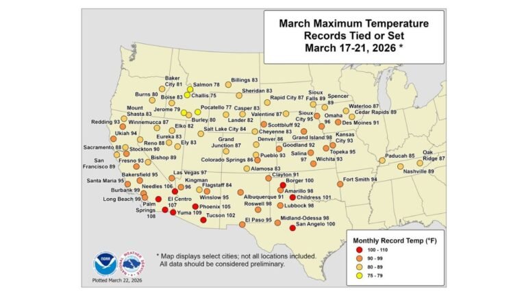
Massive Western Snowstorm to Hammer California, Utah, Colorado and Idaho With 1–3 Feet of Mountain Snow Through February 20
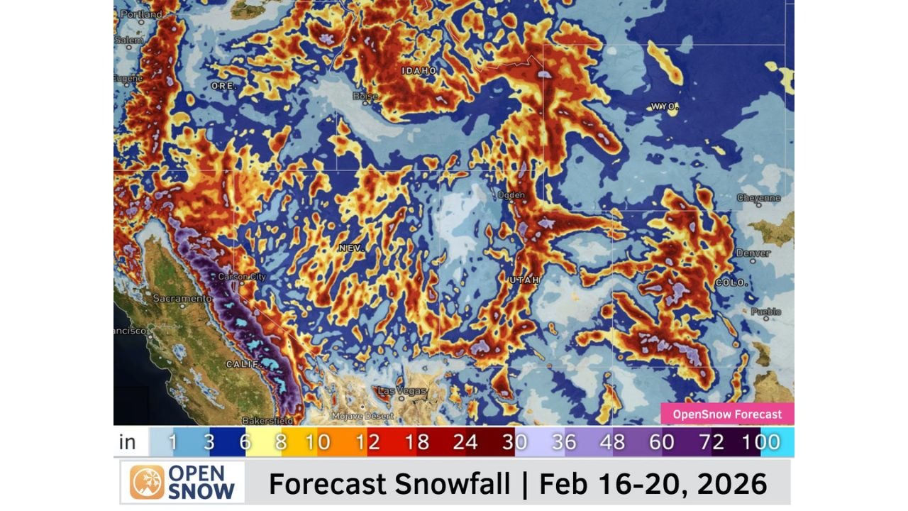
CALIFORNIA — A powerful multi-day winter pattern is now unfolding across the Western United States, with widespread mountain snowfall targeting the Sierra Nevada, Wasatch Range, central Rockies and Idaho high terrain from February 16 through February 20, 2026. Forecast projections show a broad and sustained snow footprint stretching from northern California through Utah and into Colorado, signaling a true snow cycle rather than a quick one-day system.
Sierra Nevada Positioned for Major Snow Totals
The heaviest and most consistent snowfall signal remains locked into the central and northern Sierra Nevada, including higher elevations near Lake Tahoe, east of Sacramento, and southward toward terrain above Bakersfield.
Current projections suggest:
- Widespread 12–24 inches
- Numerous mountain zones exceeding 24 inches
- Isolated peaks potentially pushing toward 30 inches or more
This pattern reflects strong Pacific moisture interacting with the Sierra crest, maximizing terrain-driven snowfall production over multiple days.
Wasatch Range and Interior West Join the Core Snow Zone
Beyond California, snowfall expands across northern Utah, particularly along the Wasatch Mountains near Ogden and north of Salt Lake City. The setup favors repeated waves of snow rather than a single concentrated burst.
Broad areas across Utah’s mountains could see 12–20 inches, with locally higher ridge-top totals possible as disturbances rotate through the larger trough.
Farther east, consistent snowfall signals extend into the central and northern Colorado Rockies, especially west of Denver, where projections show 8–18 inches across higher elevations. Portions of southern Wyoming and central Idaho are also included in the broader snow shield.
A Multi-Wave Snow Pattern, Not a One-Storm Event
This system is being driven by a deep western trough and persistent Pacific energy, allowing multiple embedded disturbances to rotate inland through the week. Rather than one dominant storm center, this pattern supports recurring snowfall rounds through February 20.
Valley locations remain far less impacted, reinforcing that this is primarily a high-elevation mountain event.
Travel and Outdoor Impacts Likely Through the Week
Mountain travel across the West could see periodic disruptions, particularly along:
- Sierra Nevada passes
- Utah canyon routes
- Colorado high-elevation highways
- Idaho mountain corridors
With snow falling in waves, conditions may fluctuate, but consistent accumulations suggest winter driving hazards at times.
The Western snow machine is clearly ramping up, and several mountain regions are positioned for one of their more productive mid-February stretches of the season.
For continued national weather updates and detailed breakdowns, stay connected with ChicagoMusicGuide.com.