Pennsylvania’s Summer Heat Ends Sunday as Temperatures Crash Into the 40s With Rain and Snow Mixing Before a Hard Freeze Drops Pittsburgh, Harrisburg and Philadelphia Into the 20s Monday Night
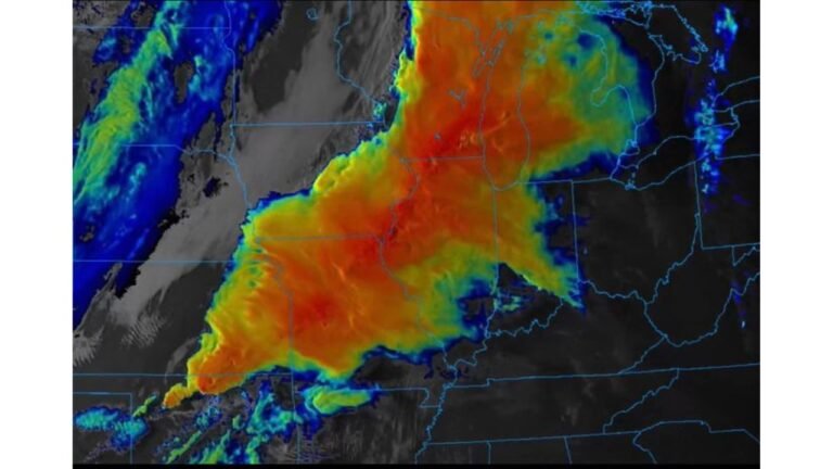
HARRISBURG, PA — The brief summer preview that Pennsylvania has been enjoying is over. A cold front is pushing through the state Sunday, April 19, 2026, dragging temperatures from unseasonably warm back to genuinely cold — and the story does not end there. By Monday night into Tuesday morning, a hard freeze is expected to grip virtually the entire state, with temperatures dropping into the 20s across most of Pennsylvania and only the far southeastern corner holding in the low 30s.
If you have plants outside, today is the day to act.
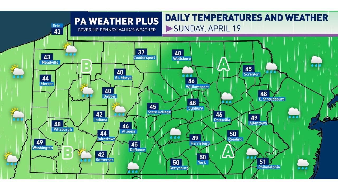
Sunday’s Temperature Crash Across Pennsylvania
High temperatures Sunday will struggle into the low to mid 40s across most of the state — a dramatic departure from the warm conditions of the past several days. The coldest readings are concentrated across the northern and central mountain regions, while the southeastern corner holds slightly warmer near the low 50s.
The full Sunday temperature map tells the story community by community. Coudersport leads the state as the coldest location at 37 degrees. DuBois, St. Marys, Indiana, and Somerset all top out at 40 to 42 degrees — barely above what most people would consider a cold winter day. Pittsburgh reaches 48 degrees, Altoona 46, State College 45, and Harrisburg 49. Moving east, Scranton hits 45, Allentown 49, and Philadelphia — the warmest city in the state Sunday — reaches only 51 degrees. Erie on the northwest corner tops at 43 degrees.
Sunday Weather by Zone
Area A — Eastern Pennsylvania (Scranton, Williamsport, Harrisburg, Philadelphia corridor) Widespread rain showers in the morning tapering off west to east by the lunch hour. Colder and breezy through the afternoon with a possible isolated rain shower returning later in the day. Snow is possible mixing into the higher elevations of northeastern Pennsylvania during the morning hours.
Area B — Western Pennsylvania (Pittsburgh, Meadville, DuBois, Somerset corridor) Possible lingering rain showers in the morning followed by a dry break through the middle of the day. Isolated to scattered rain showers return after 2 PM, and some of the heavier afternoon showers could contain snowflakes or snow pellets across the higher terrain of western Pennsylvania. No accumulation is expected at valley elevations.
Sunday High Temperature Summary
| City | Sunday High | Region |
|---|---|---|
| Coudersport | 37°F | North-Central PA |
| DuBois | 40°F | West-Central PA |
| St. Marys | 40°F | North-Central PA |
| Indiana | 42°F | Western PA |
| Somerset | 42°F | Southwest PA |
| Erie | 43°F | Northwest PA |
| Meadville | 43°F | Northwest PA |
| Mercer | 44°F | Western PA |
| Johnstown | 44°F | Southwest PA |
| Defiance | 45°F | South-Central PA |
| State College | 45°F | Central PA |
| Scranton | 45°F | Northeast PA |
| Altoona | 46°F | Central PA |
| Wellsboro | 40°F | North-Central PA |
| Williamsport | 46°F | North-Central PA |
| Pottsville | 46°F | East-Central PA |
| Pittsburgh | 48°F | Western PA |
| Sunbury | 48°F | Central PA |
| E. Stroudsburg | 48°F | Northeast PA |
| Washington | 49°F | Southwest PA |
| Harrisburg | 49°F | South-Central PA |
| Allentown | 49°F | Eastern PA |
| Reading | 50°F | Eastern PA |
| Gettysburg | 50°F | South-Central PA |
| York | 50°F | South-Central PA |
| Philadelphia | 51°F | Southeast PA |
The Hard Freeze Warning: Monday Night Into Tuesday Morning
Sunday’s cold is significant, but Monday night is the event that demands immediate action from every Pennsylvania resident with outdoor plants, gardens, or landscaping.
Temperatures across Pennsylvania on Monday night into Tuesday morning are forecast to drop well below freezing — not marginally, but deeply. Current analysis shows overnight lows of 19 to 26 degrees across northern and central Pennsylvania, with values in the 22 to 28 degree range across the Pittsburgh, State College, and Altoona corridors. Even southeastern Pennsylvania — typically the warmest part of the state overnight — will see lows in the low to mid 30s near Philadelphia and along the Delaware River corridor.
The temperature map for Monday night shows readings of 19 degrees in parts of north-central Pennsylvania — one of the coldest April overnight readings this region has seen in years. The 21 to 24 degree range covers a broad zone across northern and central Pennsylvania including counties near Wellsboro, Coudersport, DuBois, and State College. The Pittsburgh metro drops to approximately 25 to 27 degrees. Harrisburg falls near 28 to 30 degrees, and Philadelphia and the immediate southeast reach the 32 to 34 degree range.
Monday Night Freeze Temperature Summary
| Region | Forecast Low | Freeze Status |
|---|---|---|
| Northern Pennsylvania (Wellsboro, Coudersport) | 19 to 22°F | Hard freeze — dangerous for all plants |
| North-Central Pennsylvania | 21 to 24°F | Hard freeze |
| Western PA (Pittsburgh corridor) | 25 to 27°F | Hard freeze |
| Central PA (State College, Altoona) | 22 to 26°F | Hard freeze |
| South-Central PA (Harrisburg, York) | 28 to 30°F | Killing freeze |
| Eastern PA (Allentown, Scranton) | 26 to 30°F | Hard freeze |
| Southeast PA (Philadelphia fringe) | 32 to 34°F | Frost to light freeze |
What Pennsylvania Residents Must Do Before Monday Night
A freeze at these temperatures is not a marginal frost event — it is a hard freeze that will kill virtually all frost-sensitive vegetation left outdoors without protection. Tender annuals, vegetable seedlings, newly planted perennials, flowering plants, and fruit tree blossoms are all at serious risk.
Any Pennsylvania resident who put plants outside during last week’s warm stretch needs to bring them in or cover them before Monday evening. Frost cloth, old bedsheets, or any breathable covering placed over garden beds before sunset Monday can provide meaningful protection at the margins, but temperatures in the low 20s across northern Pennsylvania will defeat most light coverings. The safest action is to move susceptible plants indoors entirely before Monday night.
Forecast Confidence
Confidence: High for both Sunday’s cold front passage and Monday night’s freeze event. The cold air mass delivering these temperatures is well-established and consistent across all available model guidance. The freeze Monday night is not a borderline event — temperatures in the 19 to 26 degree range across much of Pennsylvania represent a hard, killing freeze that will impact unprotected vegetation across the entire state.
More Pennsylvania weather and freeze alert coverage is always on the horizon. Stay informed at ChicagoMusicGuide.com — your source for temperature and frost tracking across Pittsburgh, Harrisburg, Philadelphia, and the entire United States.