Severe Thunderstorm Threat Targets Southern Illinois and Indiana Thursday With Tornado Risk South of I-80
SPRINGFIELD, ILLINOIS — A localized severe weather threat is developing for Thursday afternoon and evening across southern Illinois and much of Indiana, particularly south of Interstate 80, where forecasters are monitoring the potential for low-topped supercells capable of producing a few tornadoes, hail, and damaging wind gusts. Storms are expected to move northeast before weakening later Thursday evening as they approach northern Illinois.
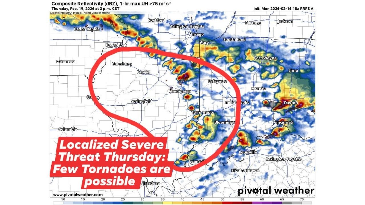
High-resolution model guidance valid for Thursday, February 19 at 3 p.m. CST shows scattered but organized convection developing along a warm front stretching across central and southern Illinois into Indiana.
Low-Topped Supercells Possible South of I-80
Forecast composite reflectivity maps indicate discrete storm cells forming from areas near Quincy, Galesburg, and Peoria, extending southeast toward Springfield, Champaign, and Terre Haute. Additional development is suggested across Bloomington, Evansville, and Indianapolis.
The key concern is the potential for low-topped supercells — storms that may not appear particularly tall on radar but can still rotate efficiently. These types of systems are known to produce:
- Isolated tornadoes
- Large hail
- Localized damaging wind gusts
The greatest tornado threat appears to be south of I-80, where atmospheric conditions may better support rotation near the warm front boundary.
Storms Expected to Lift Northeast
As the afternoon progresses, storms are projected to track northeast toward parts of Lafayette, Fort Wayne, and Dayton, though forecast guidance suggests they will gradually lose energy as they push into northern Illinois Thursday evening.
Cities including Chicago, Rockford, and Arlington Heights are expected to remain on the northern fringe of the stronger activity. While showers or thunderstorms could approach the region, the most intense severe potential is expected to stay farther south.
The corridor from Springfield to Champaign to Terre Haute and Indianapolis remains the area to watch most closely during the late afternoon and early evening hours.
Timing: Thursday Afternoon Into Early Evening
The primary window for severe weather development appears to be between 2 p.m. and 7 p.m. CST. During this period, daytime heating combined with the advancing warm front may enhance instability enough to allow rotating storms to develop.
However, forecasters emphasize that this is a localized threat, not a widespread outbreak scenario. Storm coverage is expected to be scattered, meaning not every community in the risk zone will experience severe weather.
Still, even isolated tornadoes or damaging wind events can cause significant localized impacts.
Northern Illinois Likely to See Limited Impact
Forecast trends suggest storms will weaken as they move northward, particularly as they approach northern Illinois and the Chicago metro area. The loss of daytime heating and less favorable atmospheric dynamics could reduce severe intensity by Thursday evening.
For residents across southern Illinois and Indiana, however, situational awareness will be important Thursday afternoon. The combination of a warm front and favorable wind shear creates an environment capable of supporting brief but impactful severe storms.
Emergency managers and weather officials will continue refining the forecast as new data becomes available.
As Thursday approaches, residents across Springfield, Champaign, Terre Haute, Indianapolis, Evansville, and surrounding communities should monitor updates and have multiple ways to receive weather alerts. For continued coverage of severe weather threats impacting Illinois, Indiana, and the broader Midwest, visit ChicagoMusicGuide.com.