Illinois Snow Potential Returns Thursday as Latest ECMWF Model Flips From Rain to Several Inches Across Central and Northern IL
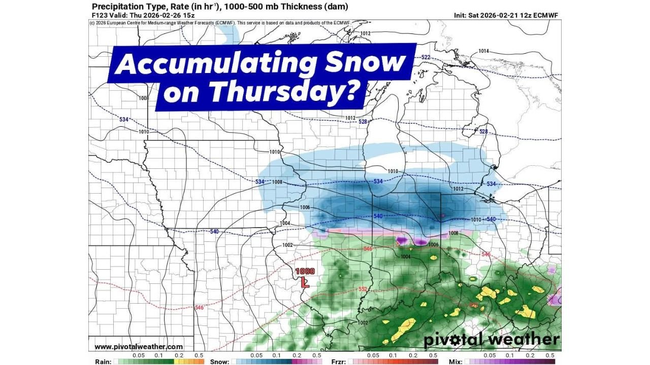
ILLINOIS — Forecast models are shifting again, and the latest data now suggests accumulating snow could fall Thursday across central and northern Illinois, replacing what earlier projections showed as mostly rain. The newest ECMWF run indicates a colder setup capable of producing several inches of snowfall, if current trends continue.
This marks a notable change from previous runs that kept much of the state in the rain zone.
Latest Model Run Shows Snow Expanding North
The updated precipitation map valid Thursday, February 26 at 15z shows a band of accumulating snow stretching west to east across portions of:
- Central Illinois
- Northern Illinois
- Parts of Indiana
- Southern Michigan
The snow band appears positioned just north of a mixed precipitation zone (pink shading), with rain (green shading) confined farther south into the Ohio Valley.
If the colder air remains locked in place, Illinois communities along and north of the rain/snow line could see measurable accumulation.
Low Pressure Tracks Through the Mid-Mississippi Valley
The model places a 1000 mb low pressure system tracking through the Mid-Mississippi Valley, pulling moisture northward while colder air wraps into Illinois from the northwest.
Thickness values shown on the map support a snow-favorable environment across much of the state — especially across central and northern counties. The key question will be:
- How far north the warm layer pushes
- Where the rain-to-snow transition sets up
- Whether snowfall rates become heavy enough for accumulation
Several Inches Possible If Trend Holds
Forecasters note that ensemble guidance is increasingly supporting the colder scenario. If this solution verifies, several inches of snowfall could occur, particularly in areas that remain solidly within the blue-shaded snow band.
However, confidence is not yet locked in.
Models have gone back and forth between:
- A warmer rain-dominant system
- A colder accumulating snow setup
The Thursday forecast will hinge on small temperature differences at multiple atmospheric levels.
Northern Illinois and Chicagoland Watching Closely
While exact placement remains uncertain, northern Illinois — including areas west and southwest of Chicago — could be within the accumulating zone if colder air holds.
Should the rain/snow line shift even slightly north, parts of the Chicago metro could also see flakes mix in or briefly change over.
Even minor shifts of 25–50 miles in the storm track could dramatically change snowfall totals.
What Happens Next
Additional model runs over the next 24–48 hours will help determine:
- Whether the colder solution continues trending
- How strong the low pressure system becomes
- The final position of the rain/snow boundary
For now, Thursday has re-entered the conversation as a potential accumulating snow day across portions of Illinois.
Residents should continue monitoring forecast updates as the setup evolves.
For continued Illinois weather updates and storm tracking coverage, visit ChicagoMusicGuide.com.