Colorado Mountain Snow Returns Wednesday With 6+ Inches Likely for Summit County and Ski Areas Near Denver
COLORADO — Mountain snow is set to return Wednesday, and this time the focus shifts toward Summit County and ski areas closer to Denver, bringing much-needed accumulation after many resorts were largely missed by the last system.
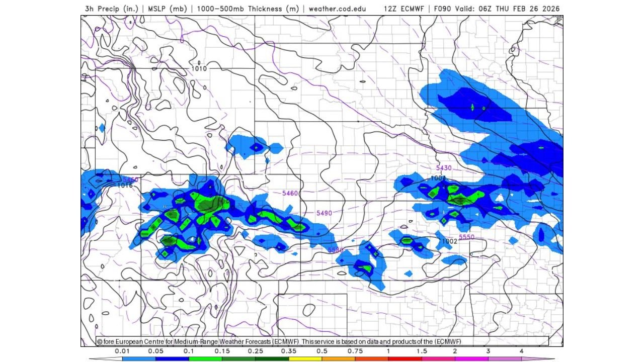
Latest model guidance shows a wave moving through the central Rockies with snowfall increasing through Wednesday before clearing early Thursday morning.
Summit County and I-70 Corridor Favored
Forecast data indicates snow bands developing across:
- Summit County
- Areas west of Denver
- High terrain along the I-70 mountain corridor
Snowfall amounts of 6 inches or more appear likely, especially in favored higher elevations. The ECMWF guidance shows steady precipitation over the central mountain zone into early Thursday (around 06Z Thursday), supporting meaningful accumulation.
Ski areas in and around:
- Breckenridge
- Keystone
- Copper Mountain
- Arapahoe Basin
could benefit significantly from this midweek refresh.
Snow + Wind = Tough Travel Wednesday
While the snowfall is welcome news for resorts, mountain travel will likely be rough on Wednesday due to:
- Falling snow
- Gusty winds
- Reduced visibility
- Potential slick conditions
Drivers along Interstate 70 through the Eisenhower Tunnel and surrounding passes should prepare for winter driving impacts during peak snowfall hours.
Clearing Expected by Thursday Morning
The system is progressive, with precipitation tapering off by early Thursday morning. Skies should begin clearing after the main wave passes, improving travel conditions heading into the end of the week.
This means:
- Fresh powder for Thursday morning skiers
- Improving road conditions later Thursday
- Limited prolonged storm impacts
Why This Setup Favors Denver-Area Mountains
Unlike the previous storm that shifted moisture farther south or west, this wave aligns better with the central mountain zone near Denver and Summit County.
Thickness values and surface pressure patterns support colder air locked in over the high terrain, allowing precipitation to fall predominantly as snow rather than rain at elevation.
Bottom Line
Colorado’s central mountains are set for a midweek snow event with 6+ inches likely in Summit County, bringing improved ski conditions but challenging travel Wednesday.
Those heading to the mountains should plan accordingly and monitor updates as snowfall timing becomes more refined.
For continued regional weather coverage and mountain updates, visit ChicagoMusicGuide.com.