Texas, Oklahoma and Arkansas Highlighted as Late February Severe Weather Signal Emerges for South-Central United States
DALLAS, TEXAS — A developing weather pattern between February 28 and March 3 is drawing attention from forecasters across the south-central United States, with model guidance signaling a possible setup for severe thunderstorms from Texas into Oklahoma and Arkansas. While overall confidence remains low at this range, ensemble data shows a fairly consistent signal for western U.S. troughing, a key ingredient for spring-like severe weather outbreaks.
Meteorologists emphasize that this is a pattern to monitor, not a confirmed outbreak — but the atmospheric pieces are beginning to align.
Ensemble Data Flags South-Central Risk Corridor
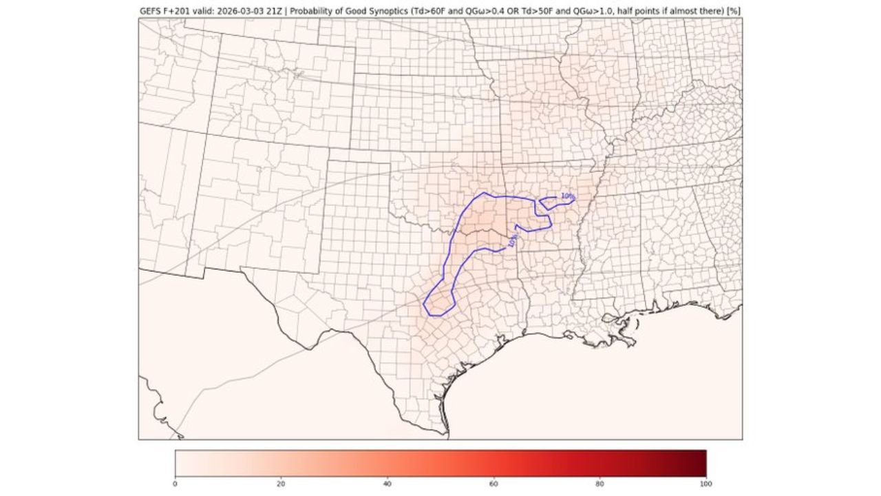
Probability maps from ensemble guidance highlight a corridor stretching from north-central Texas into central and eastern Oklahoma, and at times expanding toward western Arkansas.
The signal strengthens gradually between:
- Friday, February 28
- Sunday, March 1
- Tuesday, March 3
Each successive map shows a modest but notable probability zone centered near the Red River Valley, extending northeastward toward the Arkansas border.
While percentages are not extreme, the presence of repeated signals across multiple forecast runs increases attention among forecasters.
Western Troughing Pattern Raises Concern
A broader hemispheric map of 500mb height contours and ensemble forcing reveals a developing trough across the western United States, with ridging downstream over the eastern U.S.
This pattern typically supports:
- Increasing wind shear across the Southern Plains
- Enhanced moisture return from the Gulf of Mexico
- Strengthening upper-level jet support
When these ingredients combine over Texas and Oklahoma, the risk of organized severe thunderstorms increases.
The ensemble mean shows stronger forcing moving eastward by March 3, suggesting the most favorable dynamics could align late in the window.
Why Confidence Remains Low
Despite the promising pattern, several uncertainties remain:
- Exact placement of the trough axis
- Timing of shortwave disturbances
- Quality and depth of Gulf moisture return
- Surface boundary positioning
At 5–7 days out, small shifts in any of these factors can dramatically change the severe weather outcome.
Forecasters stress that this is a conditional threat, meaning the ingredients could align — but are not yet guaranteed to do so.
Areas Most Likely to Be Affected
Based on current ensemble probabilities, the region most consistently highlighted includes:
- North and Central Texas
- Southern and Central Oklahoma
- Portions of western Arkansas
Cities such as Dallas, Fort Worth, Oklahoma City, Tulsa, and Little Rock fall within or near the emerging probability corridor.
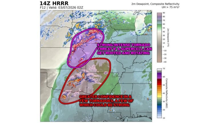
If the pattern verifies, threats could include:
- Damaging wind gusts
- Large hail
- Isolated tornado potential
However, it is too early to determine storm mode or specific hazard emphasis.
Early-Season Signal Worth Watching
Late February into early March is often a transitional period when severe weather season begins ramping up across the Southern Plains.
Western troughing combined with increasing Gulf moisture frequently marks the start of springtime thunderstorm cycles in Texas and Oklahoma.
Even though confidence remains low, the consistency of ensemble signals over multiple runs suggests this window should remain on the radar for emergency managers and weather watchers alike.
Residents across the south-central U.S. are encouraged to monitor updated forecasts through the week as higher-resolution models begin to refine the setup.
As the calendar turns toward March, early signs of severe weather season are beginning to emerge. For continued updates on developing storm threats and national weather trends, visit ChicagoMusicGuide.com.