Widespread Heavy Rain to Soak Illinois, Ohio Valley and Southeast from March 5–12 as Storm Waves Intensify Across Eastern U.S.
ILLINOIS — A strong signal is emerging for widespread heavy rainfall across the eastern half of the United States from March 5 through March 12, with northern Illinois expected to stay warm enough to avoid snow. Ensemble mean precipitation data shows repeated waves of rain and thunderstorms tracking across the Midwest, Ohio Valley, and Deep South during the first half of March.
The forecast suggests beneficial moisture for soil conditions in Illinois, but it also raises concerns about periods of steady rain and potential localized flooding as multiple systems move through.
Ensemble Data Shows Broad Swath of Heavy Rain
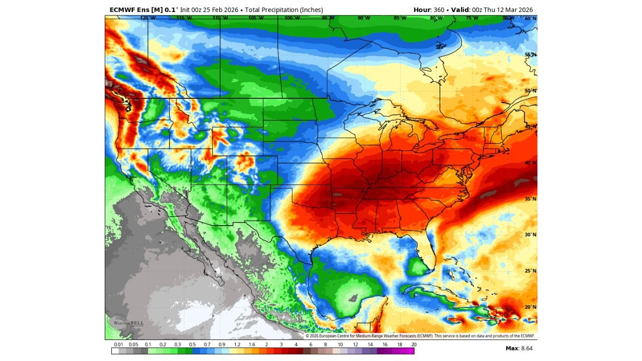
The ECMWF ensemble precipitation map highlights a significant corridor of heavier rainfall totals stretching from Texas and the Lower Mississippi Valley through Illinois, Indiana, Ohio, Kentucky, Tennessee, and into the Mid-Atlantic.
The most intense rainfall shading appears across:
- Southern Illinois
- Indiana
- Kentucky
- Tennessee
- Alabama
- Georgia
- Portions of the Carolinas and Mid-Atlantic
Several areas within this zone are projected to receive multiple inches of rainfall during the March 5–12 period. The ensemble mean suggests that rainfall totals could exceed seasonal averages in many of these locations.
For Illinois, especially Chicago and northern Illinois, rainfall appears consistent but not extreme compared to areas farther south. Still, multiple rounds of rain are expected.
No Snow Expected Across Northern Illinois
One of the more notable aspects of this pattern is the lack of cold air across northern Illinois. Forecast guidance indicates that temperatures will remain warm enough to prevent snowfall, even as storm systems move through.
This means precipitation across Chicago, Rockford, Aurora, and surrounding communities should fall primarily as rain. The absence of snow is tied to above-average temperatures across much of the eastern United States during this timeframe.
For many in Illinois, this marks a transition toward early spring conditions rather than lingering winter weather.
Waves of Systems to Bring Rain and Thunderstorms
Rather than a single storm event, the forecast suggests repeated waves of low-pressure systems crossing the region between March 5 and March 12.
These systems are expected to bring:
- Periods of steady rainfall
- Embedded thunderstorms
- Gusty winds at times
- Brief heavier downpours
The active pattern stretches from Texas and the Gulf Coast northward into the Midwest and Great Lakes, indicating a broad and energetic storm track.
Cities such as St. Louis, Indianapolis, Louisville, Nashville, Birmingham, and Atlanta sit within the corridor of higher rainfall projections.
Soil Moisture Benefits for Illinois
While prolonged rainfall can create short-term travel inconveniences, the pattern could prove beneficial for Illinois soil moisture levels heading into the spring planting season.
After fluctuating winter precipitation totals, consistent rainfall during early March can help replenish moisture reserves across central and northern Illinois. Agricultural regions may see improvement in ground conditions as long as rainfall does not become excessive in short periods.
Hydrologically, widespread rainfall without rapid snowmelt reduces the risk of major river flooding compared to winter storm scenarios.
Eastern U.S. Pattern Remains Active
Beyond Illinois, the ensemble data paints a broader picture of an active storm regime across the eastern half of the country. From the Lower Mississippi Valley through the Southeast and into the Mid-Atlantic, heavy rain signals remain strong.
Meanwhile, the western United States shows more mixed precipitation signals, with heavier precipitation confined to parts of the Pacific Northwest and Rockies.
The eastern corridor — including Illinois, Indiana, Ohio, Kentucky, Tennessee, Alabama, and Georgia — remains the primary focus for persistent rainfall.
What to Watch Heading Into Mid-March
Although exact rainfall totals will vary by location, confidence is increasing in a wetter-than-normal start to March across Illinois and much of the eastern U.S.
Key factors to monitor include:
- Timing of individual storm waves
- Localized heavier rain bands
- Thunderstorm development
- Potential ponding on roads during heavier bursts
For northern Illinois, the main takeaway is clear: rain, not snow, dominates the forecast during this window.
As the first half of March unfolds, residents across Illinois should prepare for multiple rounds of rain and occasional thunderstorms while benefiting from improved soil moisture. For continued updates on Midwest weather trends and how shifting patterns may impact travel and events, visit ChicagoMusicGuide.com.