Mississippi, Alabama and Louisiana Brace for Multiple Severe Storm Rounds as Mid-March Pattern Signals Active Tornado Season Start
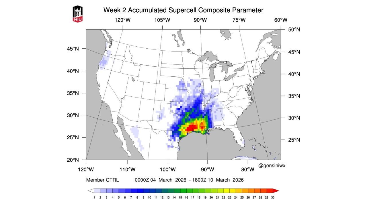
JACKSON, MISSISSIPPI — Severe storms and tornadoes may occur in more than one round across the mid-Deep South beginning the middle of next week and continuing into mid-March, according to newly released accumulated supercell composite data. The highest concentration of projected activity is centered over Louisiana, Mississippi, and Alabama, with signals extending north into Arkansas and western Tennessee.
The developing pattern could mark the beginning of a busy tornado spring season, particularly as climate signals point toward an ongoing transition toward El Niño conditions, which historically align with heightened spring tornado activity in parts of the South.
Supercell Composite Highlights Gulf Coast to Mid-South Corridor
The Week 2 accumulated Supercell Composite Parameter (SCP) map shows the strongest clustering of potential rotating storms across:
- Southern and central Louisiana
- Central and southern Mississippi
- Southern Alabama
- Coastal sections near the Gulf of Mexico
Secondary but still notable signals extend northward into Arkansas and western Tennessee, indicating that storm systems may track inland from the Gulf Coast into the Mid-South.
The highest composite values appear concentrated along the Louisiana–Mississippi border region, a historically active severe weather corridor during early spring transitions.
Multiple Occurrences Possible, Not Just One Event
Unlike single-day outbreak signals, the accumulated parameter suggests more than one severe weather window between early and mid-March. This indicates the potential for repeated storm systems rather than a one-time event.
When supercell composite parameters accumulate over several days, it often reflects:
- Persistent Gulf moisture return
- Strong upper-level wind shear
- Repeated frontal boundary interactions
These ingredients are common during early-season tornado setups across the Deep South.
Residents in Baton Rouge, New Orleans, Jackson, Hattiesburg, Montgomery, and Mobile should remain attentive as forecast confidence increases closer to the timeframe.
El Niño Transition Raises Seasonal Concerns
The discussion surrounding this setup notes that transitions toward El Niño during spring can correspond with elevated tornado seasons in portions of the southern United States.
Historically, ENSO transition years have supported:
- Enhanced jet stream energy across the southern tier
- Stronger wind shear environments
- Increased severe storm frequency
While March variability always exists, the broader seasonal signal suggests that the upcoming period could represent the beginning of a more active tornado pattern rather than an isolated week of storms.
Deep South Often More Vulnerable in Early Spring
Early-season tornado threats often shift eastward into the Deep South before the Plains fully activate later in spring. The current composite aligns with that climatological trend.
The corridor from Louisiana through Mississippi and Alabama is particularly vulnerable due to:
- Strong wind shear
- Nighttime storm potential
- High moisture content
- Tree cover and population distribution challenges
If repeated storm systems materialize as suggested, emergency management and residents alike may need to monitor forecasts closely.
Timing Still Being Refined
While the broad signal for severe weather is increasing, exact timing, storm mode, and intensity will become clearer in the coming days. Forecast models will better resolve specific event windows as shorter-range data replaces long-range ensemble projections.
However, the consistency of the accumulated supercell signal across the mid-Deep South indicates that the middle of next week into mid-March deserves close monitoring.
Early Indications of a Busier Spring
If this pattern verifies, it may represent the early stages of a busier-than-average tornado season across the southern United States. The combination of strengthening jet dynamics and favorable Gulf moisture suggests a supportive environment for organized severe storms.
Residents across Louisiana, Mississippi, Alabama, Arkansas, and western Tennessee should stay weather-aware and review severe weather safety plans as the calendar moves deeper into March.
As the mid-March window approaches, preparedness will be key across the Deep South. For continued updates on severe weather trends, tornado season developments, and regional storm outlooks, visit ChicagoMusicGuide.com.