Washington, D.C. and Northern Mid-Atlantic Could See Snow Monday Night into Tuesday as Models Consolidate Winter Storm Signal
WASHINGTON, D.C. — Weather models continue to suggest the potential for snow or mixed precipitation from Monday into Tuesday, with the most organized impact window appearing during the first half of that period. Recent data shows what previously looked like two separate waves has largely consolidated into a single, more defined system.
Cold air is expected to be firmly in place across the northern Mid-Atlantic on Monday, with afternoon highs in the 30s and morning lows in the 20s, setting the stage for wintry precipitation if moisture arrives as projected.
Best Opportunity Appears Monday Night
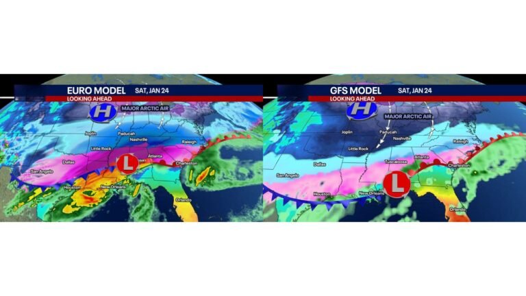
The latest European model guidance indicates that the brunt of the storm would occur Monday night, primarily as snow before tapering into a mix or even rain as temperatures fluctuate.
Meanwhile, the American GFS model brings snowfall into the region earlier on Monday, continuing through much of the day before gradually winding down. Despite timing differences, both models support measurable winter precipitation somewhere across the northern Mid-Atlantic corridor.
However, meteorologists stress that this remains several days out, meaning snowfall amounts are still highly uncertain.
Greatest Impact Focused North of D.C.
System averages currently keep the most wintry impacts from Washington, D.C. northward, including:
- Baltimore, Maryland
- Northern Virginia
- Southern Pennsylvania
- Portions of New Jersey
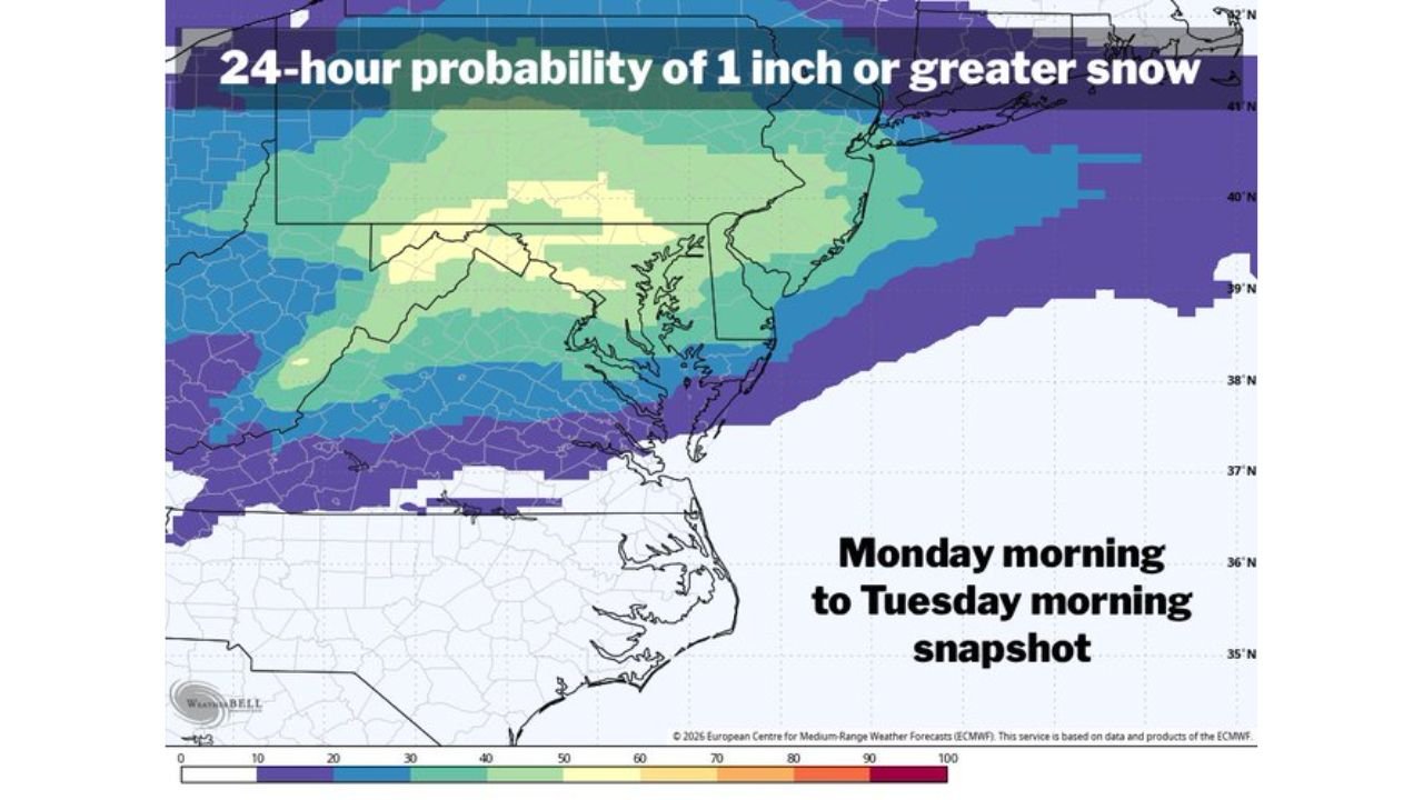
The 24-hour probability map for at least 1 inch of snow shows higher chances concentrated north of the D.C. metro area, with probabilities gradually decreasing farther south.
Areas south of the immediate D.C. region appear more likely to see a mix of precipitation or lower snow probabilities, depending on subtle temperature shifts.
Cold Air in Place, But Limited Upside
While temperatures support snow potential, some experts caution against expecting a major winter storm.
Capital Weather Gang winter weather expert Wes Junker noted that many of the models appear “overcooked” and that the storm may lack strong atmospheric support.
“That doesn’t preclude snow but suggests there’s not much of an upside from a dusting to 3 inches despite the model forecasts,” Junker wrote.
This perspective reinforces the idea that while plowable snow is possible, extreme accumulations currently look unlikely.
Storm Track and Intensity Still Evolving
The system’s exact track will ultimately determine who sees primarily snow versus mixed precipitation or rain. A slight northward or southward shift could significantly alter outcomes across:
- Washington, D.C.
- Baltimore
- Philadelphia
- Richmond, Virginia
If colder air remains locked in longer than expected, snowfall totals could increase. Conversely, a faster intrusion of milder air could reduce accumulation potential.
Early Week Travel May Be Affected
With the most likely window spanning Monday morning through Tuesday morning, commuters across the D.C. and Baltimore metro areas should monitor forecast updates closely.
Even light snowfall during peak travel periods can cause disruptions, especially if road temperatures remain near freezing.
What to Watch Next
Over the coming days, forecasters will refine:
- Storm track placement
- Precipitation type distribution
- Timing of peak intensity
- Snow-to-mix transition zones
Confidence is growing that some form of wintry precipitation will occur, but the magnitude remains in question.
For now, the signal supports light to moderate snowfall potential primarily north of Washington, D.C., with lesser impacts farther south.
As updated data arrives, residents across Washington, D.C., Maryland, Virginia, and southern Pennsylvania should stay alert for changing forecasts. For continued updates on winter weather developments and regional forecast trends, visit ChicagoMusicGuide.com.