Chicago to Minneapolis in Crosshairs as Hypothetical SPC Outlook Shows High-End Tornado Setup Across Midwest and Mid-South
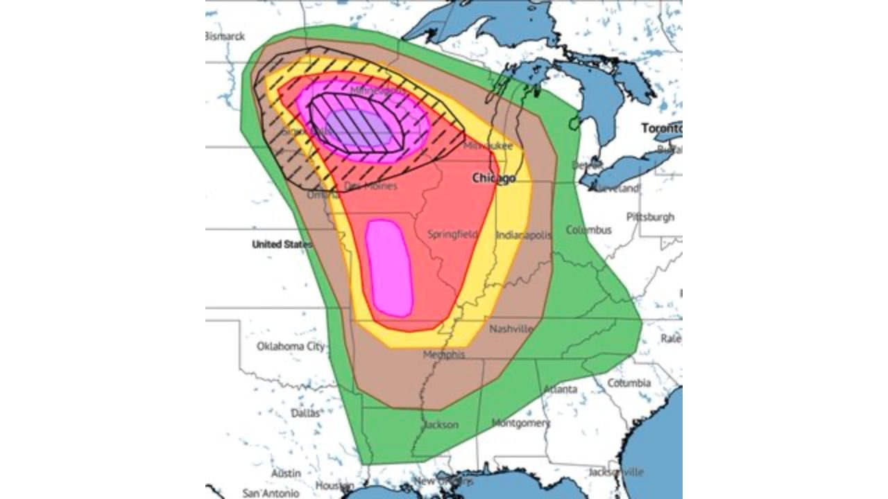
CHICAGO, ILLINOIS — A hypothetical Storm Prediction Center-style outlook map is illustrating what could be a high-end severe weather setup stretching from the Upper Midwest through the Mid-South, with Chicago positioned inside a broad enhanced risk corridor and areas farther northwest facing the potential for numerous intense tornadoes.
While this scenario remains conceptual and not an official SPC forecast, the structure of the outlook highlights a setup capable of producing both embedded strong tornadoes to the north and a messy but highly tornadic squall line to the south.
Highest Tornado Risk Centered Near Minneapolis and Upper Midwest
The most intense shading on the outlook is centered near Minneapolis, Minnesota, extending into portions of:
- Western Wisconsin
- Eastern South Dakota
- Northern Iowa
This zone is depicted with strong hatching, typically associated with the potential for significant tornadoes. In such a configuration, discrete supercells could develop ahead of a cold front or dryline, allowing storms to remain isolated long enough to produce intense, possibly long-track tornadoes.
The placement suggests the greatest concentration of violent storm potential would be north of Chicago, particularly across the Upper Midwest.
Chicago Inside Broad Enhanced Severe Corridor
Chicago sits within a large enhanced risk area extending from:
- Central Illinois
- Northern Indiana
- Southern Wisconsin
- Western Michigan
While not at the center of the most intense hatched zone, Chicago remains in a region supportive of organized severe thunderstorms.
In this type of setup, the city could experience:
- Rotating supercells
- Damaging straight-line winds
- Large hail
- Tornado potential
Storm mode near Chicago would depend on timing and whether storms remain discrete or consolidate into a line.
Messy but Highly Tornadic Line Possible to the South
Farther south, the outlook expands into a broad risk corridor covering:
- Springfield, Illinois
- Indianapolis, Indiana
- Nashville, Tennessee
- Memphis, Tennessee
- Jackson, Mississippi
The southern portion of the risk area suggests the development of a more linear storm mode — potentially a squall line — but one that still maintains very high tornadic parameters.
In these setups, tornadoes can develop within embedded circulations along the line, sometimes occurring rapidly with limited visual cues. Damaging wind potential often accompanies such systems.
Large-Scale Pattern Supports High-End Setup
Although this map represents a modeled scenario, the structure implies a classic high-impact configuration featuring:
- Strong upper-level jet dynamics
- Deep-layer wind shear
- A sharpening frontal boundary
- Rich Gulf moisture surging northward
This combination frequently produces a dual-threat event — discrete supercells in the northern sector and a fast-moving squall line farther south.
The hypothetical outlook highlights how severe weather could organize across a wide swath of the Midwest and Mid-South simultaneously.
Multi-State Impact Zone
If a pattern resembling this scenario were to verify, states potentially impacted would include:
- Minnesota
- Wisconsin
- Illinois
- Indiana
- Iowa
- Missouri
- Tennessee
- Mississippi
- Portions of Michigan and Kentucky
Major metro areas such as Chicago, Minneapolis, Milwaukee, Indianapolis, Nashville, and Memphis would all sit within varying levels of severe risk.
Why This Scenario Stands Out
The key feature of this outlook is the combination of:
- Numerous embedded intense tornadoes to the north
- A highly tornadic squall line to the south
- Broad geographic coverage
Such setups are often associated with significant severe weather days during peak spring transition periods.
While this depiction is hypothetical and meant to illustrate potential, it underscores how quickly a dynamic Midwest pattern can organize into a high-end severe weather event.
As spring approaches and atmospheric dynamics strengthen, residents across Chicago and the broader Midwest should remain aware of evolving forecast trends. For continued updates on severe weather setups, storm outlooks, and regional weather developments, visit ChicagoMusicGuide.com.